The total mileage for this hike is 5 miles with about 800 ft. of elevation gain. We will start at the trail head of the Borrego Trail, which is right off of the parking lot. This is where we will meet. We will head up the Borrego Trail until we get to Mustard Road. Here […]
This hike starts at 8:30 am to beat the heat from Gold Canyon Trail to Wildwood Canyon Trail. It will pass through various trails with a long creek, crossing streams and bridges, Indian caves, volcanic rock cliffs, water falls, cacti-filled desert environs, riparian forest, and wildflowers. Highlights of the hike include waterfalls incorporating 40’ Paradise […]
Today we will hike up the Chumash Trail in Simi Valley, and turn left at the top to the "Triangle" as Barbara calls it. The hike will be an out and back, and will be 7.7 miles with 1600 ft gain. It's a nice mostly single track trail during the first climb with pretty views […]
Meet at the Rosewood sign, which is on the Regal Oak Ct. and Lynn Rd. intersection. The hike is about 5 miles with an elevation gain/loss approximately 900’. We'll walk a short distance on Lynn road to the lower Rosewood Trail, then take the dirt trail up a shaded ravine and continue on the Rosewood […]
Another HWD Original! Many of you know Paramount Ranch for its Western Town filming set (destroyed by the Woolsey fire). But did you know that during the 1950s it was home to a world-class race track? The broken sections of asphalt that twist through the eucalyptus trees and around the old Western Town was in […]
The total distance for this hike is 4.5 miles with about 650 ft. of elevation gain. There are great mountain and ocean views along the ridge. We are going to start on Bommer Ridge Trail and take this to Lizard Trail. We will go down that and loop back up to Bommer via Upper Laurel. […]
This will be the last hike to the MASH site, via the Grasslands Trail, until spring because the Malibu Creek bridge is scheduled for removal on this day. We'll stop by Century Lake along the way. Hike is about 7 miles with 1,000' gain and rated MEDIUM. See the HWD Hike Rating Guide Post-hike lunch […]
Palo Comado ("Burnt Stick" in Spanish) tells you a lot about the environs - frequently burned over by wildfires, this was directly in the line of the Woolsey Fire but much of the vegetation has re-grown. This is one of many routes from the Conejo Valley to China Flat. Except for one turn near the […]
It's been a long time since Hiking Plus has been to The Canyon Club as a group, so let's change that with one of our favorite, fun bands- Fast Times. Playing an astounding assortment of 80's music guaranteed to have you dancing and/or singing along, we've seen Spicoli, Slash, Nikki, and Devo at several summer […]
This hike will be about 5.4 miles total with 820 ft. of elevation gain. We are starting at the parking lot at the Wahoo's parking lot. We will take Live Oak Trail. This turns into Serrano Road which will take us to Serrano Cow Trail. At this part of the trail, we usually see a […]
PIER TO PEAK WALKABOUT IN THE DOWNTOWN VENTURA AREA! JOIN THE GROUP WHEN/WHEREEVER YOU CAN/WANT... Times given are my best guesstimate for movement between the stated destinations, including loitering time and may be adjusted slightly as needed throughout the day. Someone in the lead group may post Messages here on where we are during the […]
We are going to be starting at the Canyon View Staging Area. This hike will be about 6.2 miles with around 1,000 ft. of elevation gain. We will be starting at Canyon View Park and taking Cholla up to West Ridge and comic down Mathis. Link to Parking from Google Maps: https://www.google.com/maps/place/Canyon+View+Staging+Area/@33.585273,-117.7465062,17z/data=!3m1!4b1!4m5!3m4!1s0x80dce61b6bd45c2d:0x5ef3f1ad687cc8b5!8m2!3d33.585273!4d-117.7443175 Dogs are not […]
We're Back in Action! DESCRIPTION: Initial challenging climb up a canyon with a running stream to an old Campground, then a long fire road to top, then a long section of the PCT back down to the Canyon for the descent down the mountain. Lollipop style. Portions of this hike were burned in the Lake […]
Please join a beautiful hike in Upper Las Virgenes Preserve and Cheeseboro Canyon! We'll do my classic loop (a little different than the classic book version) and start at the northern end of Las Virgenes Rd, traverse the Chesebro ridge trail past the Baleen Wall to Shepherd's flat and then turn east along a beautiful […]
UPDATE: Please review our guidelines to participate in our hikes. Here are some highlights and a link to the guidelines: https://www.meetup.com/The-Weekday-Trailblazers/about/ Restrictions apply for your safety and ours: Don't show up unless you're on the "Attending" list No "Plus Ones" on this hike Plan on completing the entire hike at a reasonable pace or please […]
The Ray Miller Trail is an awesome blend of ocean and mountain views in Malibu’s La Jolla Canyon. We will start from the trailhead which follows the canyon eastward, away from the ocean. Then, it quickly brings you back toward the ocean at a gradual incline. There’s a great lookout spot where it gives you […]
Intermediate, 5.25 mi, 1000' gain Easy option: 2.8 mi, 700' gain. Even easier option: 2.2 mi, 600' gain. Fit beginners can complete this hike, but it will certainly get their blood pumping. This is not a conditioning hike, it's a social hike. We'll be stopping at various points to let people catch up and to […]
Please bring a headlamp or flashlight. Please review our guidelines to participate in our hikes. Restrictions apply for your safety and ours: Don't show up unless you're on the "Attending" list No "Plus Ones" on this hike Plan on completing the entire hike at a reasonable pace or please find an alternative hike that better […]
This is not an event, rather a call to action. One of our members, Jackie, will be taking donations of items and is also looking for volunteers to help the homeless in the downtown area. Please consider doing what you can to help. She is seeking the following donation items: 1. Warm clothing, jackets, sweaters, […]
This hike will be about 5.4 miles total with 820 ft. of elevation gain. We are starting at the parking lot at the Wahoo's parking lot. We will take Live Oak Trail. This turns into Serrano Road which will take us to Serrano Cow Trail. At this part of the trail, we usually see a […]
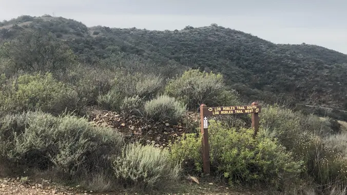
This loop hike is about 5 miles with about 800' of total elevation gain, spread out nicely, with a little bonus loop through Oak Creek Canyon. "Robles" is Spanish for oaks, and we'll see plenty of them on this beautiful, hike. Trailhead Directions: From the 101 in Thousand Oaks, turn south on Moorpark Road. Drive […]
This hike is in the same area as Laurie has posted for Thursday (Los Robles Open Space) but in a different parking area (at the end of Greenmeadow Avenue). This hike is only 5 miles and a bit slower. Oak Creek Canyon Trail is a rather special trail in Los Robles Open Space that is […]
Many from this group, plus other friends, will attend this event at Sagebrush Cantina. The band playing (Hindsite) puts on a fantastic show, playing dance, pop, r&b/funk, and hip hop music from the 70's up to the latest hits. This is one of the best venues I've experienced on LA's west side, and this is […]
Note: If you signed up for Hindsite this Friday, I've put you back on this RSVP list, you can sign off or add guests if you'd like. So, Hindsite had to cancel this Friday, but we can still have some fun and get our dance on with the band filling in, 805 Social Club. I've […]
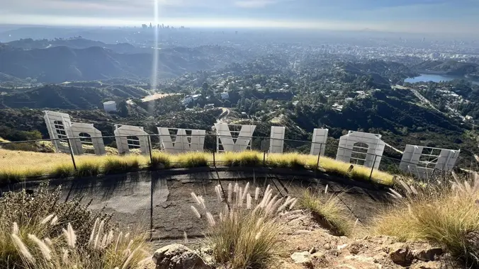
Hike #12 in the 2023 Saturday in the Santa Monica Mountains series, will be an adventurous 11-mile, 3000’ hiked from Burbank Peak to Beacon Hill passing by Bee Rock, the Hollywood Sign, Dante’s View, and the Old Zoo. Peaklets, rocks, and hills include Bee Rock (1056’), Taco Peak (1572'), Mt. Bell (1587’), Baby Bell (1570’), […]
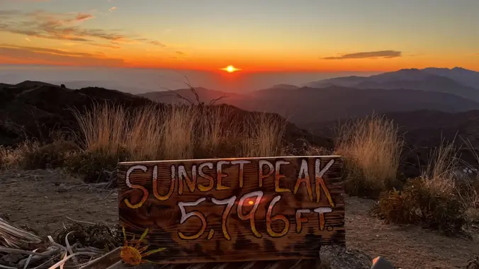
WTC INTRODUCTORY HIKE: Echo Mtn and Mt Lowe (5597’) via Old Railway Route Hike the Sam Merrill trail to the historic railway and resort area at Echo Mtn, then up the old Railway Road and on to Mt Lowe. We will return the same way. Trip is a total of 12 miles with 3900 ft […]
The hike I am planning is around 6.3 miles with about 700 ft. of elevation gain. It starts at the very end of the paved road, the long gray strip that can be seen on the map. We will begin at the Bell Canyon Trail head. We will continue onto that and then take it […]
This is an adventurous Sunday Griffith Park Peaklet 11-mile, 3000’ hiked from Burbank Peak to Beacon Hill passing by Bee Rock, the Hollywood Sign, Dante’s View, and the Old Zoo. Peaklets, rocks, and hills include Bee Rock (1056’), Taco Peak (1572'), Mt. Bell (1587’), Baby Bell (1570’), Mt. Chapel (1622’), Mt. Lee (1640’), Cahuenga Peak […]
The hike will be about 4.5 miles with about 500 ft. of elevation gain. We will start on Peters Canyon Trail and take this to East Ridge View Trail. This is where we will go up Big Red. Then we will continue on this trail until we get to Eucalyptus to loop back. We will […]
Experience one of the world’s most beloved pieces of music in a fresh, new way. Areté Symphonic Choir will perform the Christmas portion of Handel’s musical masterpiece, Messiah, as treasures of visual art by master painters are projected above the stage. Join us for this unique marriage of music and art – a bold new […]
Do you need a break in your workweek? Does the thought of hiking along the beach and surrounding hills brighten your spirits? Then join us for the Playa Del Rey conditioning walk. The walk is 5 miles, 200 ft gain. Directions to meeting point: Go West on Culver Blvd, to Nicholson, turn Left (Note: Nicholson […]
The total distance is around 4.6 miles with 870' of elevation gain. We will take Boat Canyon Trail up to Bommer Canyon. We will take Bommer to Water Tank trail. We will take this and then take a lower trail back to the beginning. Address: Dartmoor Trail Lookout Laguna Beach, CA 92651 https://goo.gl/maps/6N8c88XfdSeYu85M8 Dogs are […]
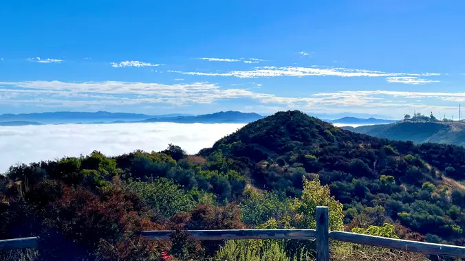
Let's head out to the famed Peace, Love, Joy arch at the Danielson. This out and back hike wanders through grasslands and chaparral from the Wendy trailhead, then climbs up Boney Mountain Trail for some fantastic views north to Port Hueneme and Oxnard and west toward the Pacific Ocean. If it’s a clear day we’ll […]
PLEASE NOTE: We will meet under the solar panels and NOT by the tennis courts. This hike is in addition to the longer hike on Tuesday, but we will be shorter and slower. Restrictions apply for your safety and ours: Don't show up unless you're on the "Attending" list Unregistered or waitlisted will be turned […]
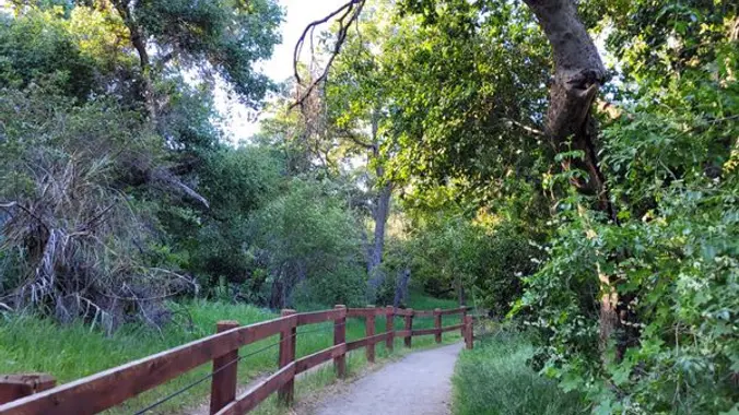
Solstice Canyon is the quintessential coastal canyon. The year-round stream provides ample water to support this 550-acre park’s numerous plant communities and a diverse wildlife population. You will love the natural beauty of Solstice Canyon, yet wildfires have left behind the architectural ruins of our recent past. During our trek we will pass remains of […]
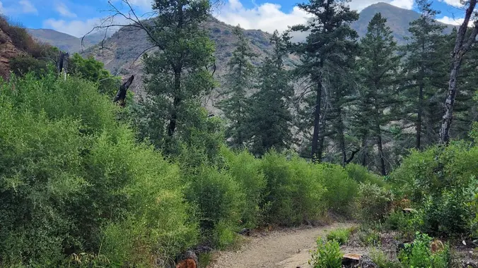
Please bring a headlamp or flashlight. Wildwood Park in Thousand Oaks is one of the most versatile local parks there is, with 27 miles of trails skittering through rocky cliffs, cacti-filled desert environs, volcanic rock, riparian forest, and a cool, watery canyon. Highlights of the hike include waterfalls incorporating 40’ Paradise waterfalls along with a […]
This hike will be about 5.4 miles total with 820 ft. of elevation gain. We are starting at the parking lot at the Wahoo's parking lot. We will take Live Oak Trail. This turns into Serrano Road which will take us to Serrano Cow Trail. At this part of the trail, we usually see a […]
Overflow and earlier hikers: an 8:30 alternative to the Stagecoach Museum hike. Meet at the Rosewood sign, which is on the Regal Oak Ct. and Lynn Rd. intersection. The hike is about 5 miles with an elevation gain/loss approximately 900’. We'll walk a short distance on Lynn road to the lower Rosewood Trail, then take […]
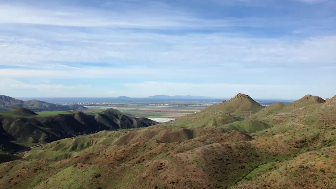
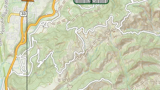
Let’s do our Sulphur Mountain hike before winter rains muddy the track. This route ascends from the Girl Scout camp, through petroleum-scented oak forest, to cattle grazing ranch land at the top. We’ll have spectacular views of the Ojai Valley, Lake Casitas, and the mountains to the north. Lunch afterwards at Om Thai Cafe, just […]
Come on out and join your friends, make new ones, and dance to a great 80's band at one of our favorite places. 80's Invasion, led by Dirk Knight and Mony Mony, are a fun, high-energy act that does cool covers of everything 80's (with a little 70's and 90's mixed in sometimes.) They have […]
We will be playing it by ear a bit, but we will be doing a hike that will be around 5 miles with 800-900 ft. of elevation gain. **You do not need to register on LetsGoOutside.org, but if is optional and you will be emailed extra details and a map. https://letsgooutside.org/activities/2023/12/16/wilderness-access-day-bommer-canyon-114/ Enjoy self-guided access in […]
PCT - Eagle Rock via Montezuma Valley Rd THIS IS A DAY HIKE Days: 3-4 hrs Milage: 9-10 MILES Elevation Gain: 1,070 ft Type of Trip: Day Hiking Difficulty: Moderate Location: ANZA BORREGO DESERT Starting Point: Montezuma Valley Rd Ending: Montezuma Valley Rd Location: 33°13'00.8"N 116°35'16.5"W GOOGLE MAPS TRAIL MAP Eagle Rock is a popular […]
Please join us for the Hiking Plus Annual Holiday Dinner. This is a sit down dinner with our Hiking Plus friends in a private room. Because of limited space, everybody initially goes on the waiting list. This is a reservation event. Please RSVP only if you plan on showing up at event time, and remove […]
We are going to be doing a different hike at the park, (not at the main park entrance). We are going to be starting at the Canyon View Staging Area. This hike is roughly 7 miles with relatively low elevation gain. The expectation is to definitely make it to Cave Rock and Dripping Cave. Hopefully […]
The hike we will be doing will be around 5 miles long with 875 ft. of elevation gain. This will be a loop starting at the parking lot of Nix Nature Center. As you will see on the map, this is at the main park entrance off of the 133 (Little Sycamore Canyon Staging Area). […]
We will start (early to beat the heat) our hike near the beginning of Regal Oak Ct. on the lower Rosewood Trail, a dirt trail heading up a shaded ravine at the base of the mountains, and continue to the usual Rosewood trail. Rosewood trail presents a clear view over the 101 Freeway carving up […]
In just under 7 miles, this "super-duper-double-looper" will explore the heart of Topanga State Park (TSP) and touch all of TSP's major trailheads. Starting at Trippet Ranch, we will head up TSP's Nature Trail which crosses Eagle Springs Fire Road near the junction of the East Topanga Fire Road (jumping off point to Parker Mesa). […]
The hike we will be doing is a loop at about 5.5 miles with 725 ft. of elevation gain. We will meet at the Willow Staging Area that is right off of the 133. We will begin at the trail head of the Laurel Canyon Trail. We will take this to Lizard Trail, then we […]
The total distance is around 4.6 miles with 870' of elevation gain. We will take Boat Canyon Trail up to Bommer Canyon. We will take Bommer to Water Tank trail. We will take this and then take a lower trail back to the beginning. Address: Dartmoor Trail Lookout Laguna Beach, CA 92651 https://goo.gl/maps/6N8c88XfdSeYu85M8 Dogs are […]
I'm excited to do this hike again! This hike is really cool so you should come out and join us! This hike will be about 10 miles with 1,300 ft. of elevation gain. We will start at the same place we do for the falls (Black Star Trailhead). We will take this road all the […]
This hike will be about 5.4 miles total with 820 ft. of elevation gain. We are starting at the parking lot at the Wahoo's parking lot. We will take Live Oak Trail. This turns into Serrano Road which will take us to Serrano Cow Trail. At this part of the trail, we usually see a […]
The total distance is around 4.6 miles with 870' of elevation gain. We will take Boat Canyon Trail up to Bommer Canyon. We will take Bommer to Water Tank trail. We will take this and then take a lower trail back to the beginning. Address: Dartmoor Trail Lookout Laguna Beach, CA 92651 https://goo.gl/maps/6N8c88XfdSeYu85M8 Dogs are […]
Let's try Ray Miller Trail after last week’s rain. The trail is an awesome blend of ocean and mountain views in Malibu’s La Jolla Canyon. We will start from the trailhead which follows the canyon eastward, away from the ocean. Then, it quickly brings you back toward the ocean at a gradual incline. There’s a […]
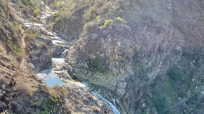
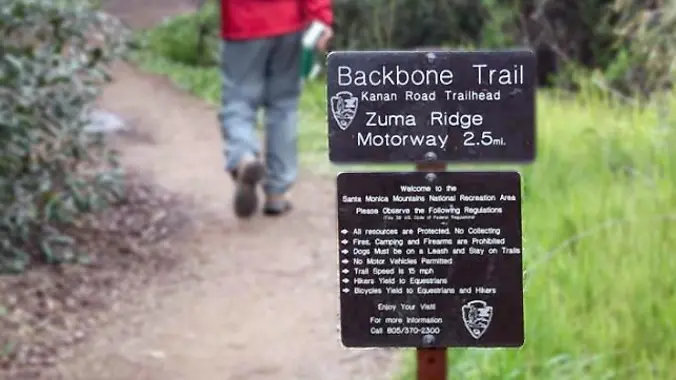
http://photos1.meetupstatic.com/photos/event/b/a/2/4/event_99467652.jpeg Hoping the trail will dry out a bit. The waterfall should be flowing. From the Kanan Rd trailhead, we'll jump on the Backbone Trail for a cruise down into Newton Canyon. On our way there, we'll cross the creek, pass under an oak canopy, and come out into an opening. At the opening, look […]
This hike will be about 5.4 miles total with 820 ft. of elevation gain. We are starting at the parking lot at the Wahoo's parking lot. We will take Live Oak Trail. This turns into Serrano Road which will take us to Serrano Cow Trail. At this part of the trail, we usually see a […]
This hike circles the trails between South Ranch and Conejo Ridge. The conditions are ideal for this 6 mile (1000 foot elevation gain) lollipop. As of Tuesday, the trails were well drained (NOT muddy) with panoramic views of Conejo Valley (Ladyface Mtn, Las Virgenes Reservoir, Lake Sherwood). We will start at the trailhead at Triunfo […]
DESCRIPTION: We'll start from Whitney Canyon Park and hike along the Santa Clara Divide Road to Los Pinetos where you'll be treated to stunning 360 degree views of the local valleys and if it's a clear day beautiful downtown Los Angeles! It's an out and back trail that not only delivers not only scenic panoramas […]
The total mileage for this hike is 5 miles with about 800 ft. of elevation gain. We will start at the trail head of the Borrego Trail, which is right off of the parking lot. This is where we will meet. We will head up the Borrego Trail until we get to Mustard Road. Here […]
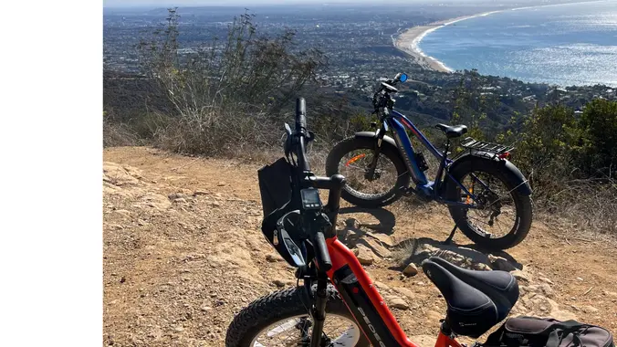
Did you get an ebike for Xmas? All bikes are welcome. On this one we’ll travel through Topanga State Park with stops at Eagle Rock, Parker Mesa, the Hub, Eagle Springs and more. We’ll ride at a pace suitable for semi-beginners on mostly fireroads. There will be nothing technical. Planned ride is a about 20 […]
This hike will be about 7 miles with about 700 ft. of elevation gain. We will start the hike at Cañada Vista Park. From here we will take the Tijeras Creek Trail to the Arroyo Trabuco Trail and use this to loop back to where we started. There will be a few water crossings, so […]
Trail statistics are approximate. For safety purposes always assume they are underestimated. But don’t be disappointed if they are overestimated. Bring more water and snacks than you think you’ll need.
Trail descriptions are based on previous hikes. Current conditions are unknown until arrival. Expect the unexpected and plan accordingly.
The Organizers and members of Hiking With Dean are not professional leaders, guides, or mountaineers. The function of the member or organizer is only to organize the trip. Each person who shows up for a trip/meetup (and their guest or guests) is responsible for his or her own safety. By attending a hike, or any other event organized by this group, you are acknowledging that you and any guests that you bring are aware of the risks, dangers and hazards associated with the activity and freely accept and fully assume all such risks, dangers and hazards, and further agree to release and discharge the Organizers, Members of the Hiking With Dean Meetup Group from and against any and all liability arising from your participation in the group activities per our ASSUMPTION OF RISK AND LIABILITY WAIVER and Section 6.2 of the Meetup.com Terms of Service.


Recent Comments