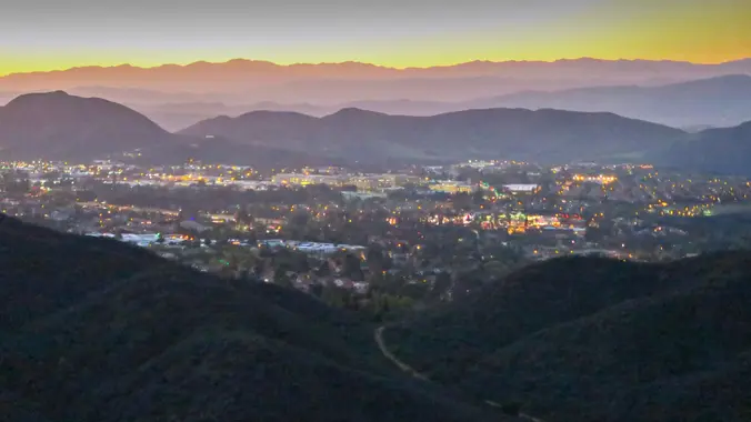
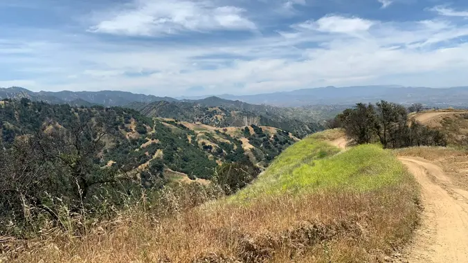
Happy 2024! We'll be starting our hike on the Castillo Trail in Wildwood Park, probably a new trail head for many of you. From there we'll descend into Wildwood Canyon with a couple of creek crossings and hook up with the Lynnmere Trail. We'll loop around the south side of Wildwood Park with awesome views […]
Happy New Year 2024! Let's start our new year on the trail!! Easy-Intermediate, 4 miles, 800' gain. Option not to hike: If for some reason you don't want to hike but still want to come, the social event can be driven to, and the main group of hikers should get there about an hour after […]
The total distance for this hike is 4.5 miles with about 650 ft. of elevation gain. There are great mountain and ocean views along the ridge. We are going to start on Bommer Ridge Trail and take this to Lizard Trail. We will go down that and loop back up to Bommer via Upper Laurel. […]
The total mileage for this hike is 5 miles with about 800 ft. of elevation gain. We will start at the trail head of the Borrego Trail, which is right off of the parking lot. This is where we will meet. We will head up the Borrego Trail until we get to Mustard Road. Here […]
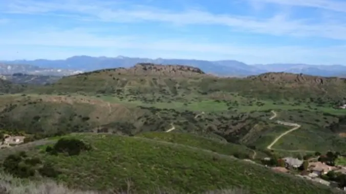
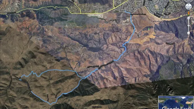
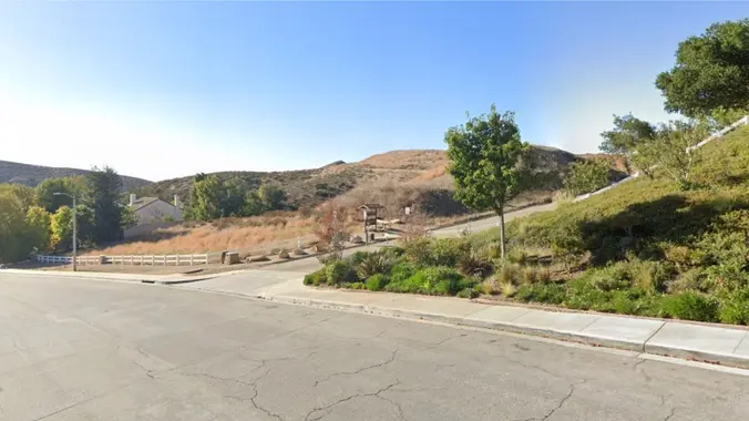
This week we’ll do a loop around the northeastern regions of the Santa Monica Mountains National Recreation Area and the Las Virgenes Open Space. This area traverses many ecosystems, including riparian, chaparral, and the rockscape from Galaxy Quest. The area is generally dry, but very nice! http://photos1.meetupstatic.com/photos/event/c/3/0/c/event_255709932.jpeg The trailhead is where Sunnycrest turns into Doubletree, […]
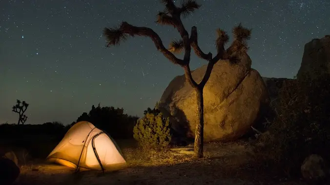
Desert camping, starry skies, and amazing rock formations! ⛺️ 🪨 We have a group site for up to 25 people. 😀 Carpooling highly recommended. Camping fees to be split among attendees. Severe weather (high winds, extreme cold) will cancel event. More info will be emailed to those who RSVP. See you there!
Instead of our usual starting point at the Conejo Playfields, this shorter, gentler hike will start at the top of Camino Magenta, in the beautiful unincorporated Lynn Ranch neighborhood surrounded by Thousand Oaks. We'll do a clockwise loop around the gated Lynnmere community and wind up back at our starting point about 5 miles and […]
This is an alternative, and probably slower hike for Thursday, a gentler hike. We will start in the parking lot of SMMNRA and can go up to the monument if it is dry (it's not suppose to rain). We will take this hike at a gentler pace and we will take some breaks to let […]
Let's hike at the Back Bay in Newport. The plan is to do 4-5 miles. It will be an out and back. A lot of the trail is asphalt. You can wear hiking or running shoes. There is a Upper Newport Back Bay Nature Preserve parking lot right off University Dr. and Irvine Ave. (See […]
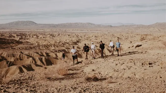
Intermediate Backpacking Trip (only because it's a Dry Camp) Milage: 7 - 14 miles (depending on route) Some Cross country hiking. Ascent: +700-1000 ft High clearance vehicles recommended....but we have seen regular car make it. Dry camp (no water) Maps/GPX files/Google map From last year trip. Instagram Video) There are several places in Anza-Borrego State […]
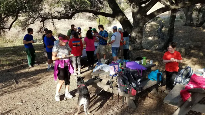
Ok . . . so you made a New Years Resolution to be active and get out. As well as to be more social in the new year. This is the event to get the ball rolling. OR Maybe you have heard of these but not been able to make it there before now. OR […]
DESCRIPTION: We'll start from Whitney Canyon Park and hike along the Santa Clara Divide Road to Los Pinetos where you'll be treated to stunning 360 degree views of the local valleys and if it's a clear day beautiful downtown Los Angeles! It's an out and back trail that not only delivers scenic panoramas but a […]
The hike I am planning is around 6.3 miles with about 700 ft. of elevation gain. It starts at the very end of the paved road, the long gray strip that can be seen on the map. We will begin at the Bell Canyon Trail head. We will continue onto that and then take it […]
Join our 7.3-mile conditioning hike to Bedford Peak on Sunday, January 7, 2023, at 7 am via the Maple Springs Trail. The trail ascends 2066 feet, taking approximately 4.5 hours, offering stunning views of the Pacific Ocean, Catalina Island, and San Gorgonio Mountains at the summit. Bring the 10 essentials, 2 liters of water, snacks, […]
Shed those holiday calories by joining us for a refreshing hike in the sunshine. The loop trail begins at Kenneth Hahn East, winds its way to Kenneth Hahn West, and includes a climb up 282 steps before returning to the starting point. Along the journey, enjoy a panoramic 360-degree view of downtown LA, Hollywood, and […]
We’ll start up the single track in pretty Caballero Canyon to Dirt Mulholland, and then head East on the fire road for only less than a 1/4 mile and take another single track trail through beautiful canyons to a scenic overlook with views of the San Fernando Valley and the ocean. Here we will take […]
The total distance is around 4.6 miles with 870' of elevation gain. We will take Boat Canyon Trail up to Bommer Canyon. We will take Bommer to Water Tank trail. We will take this and then take a lower trail back to the beginning. Address: Dartmoor Trail Lookout Laguna Beach, CA 92651 https://goo.gl/maps/6N8c88XfdSeYu85M8 Dogs are […]
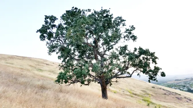
Encinal Canyon is named for encina, the Spanish word for the holm oak, a lovely Mediterranean tree with holly characteristics. Holm oaks are one of the main trees used to establish truffle orchards, but we'll be nosing around the canyon strictly for its beauty. The trail from Encinal is a smooth, firm, and well-traveled single […]
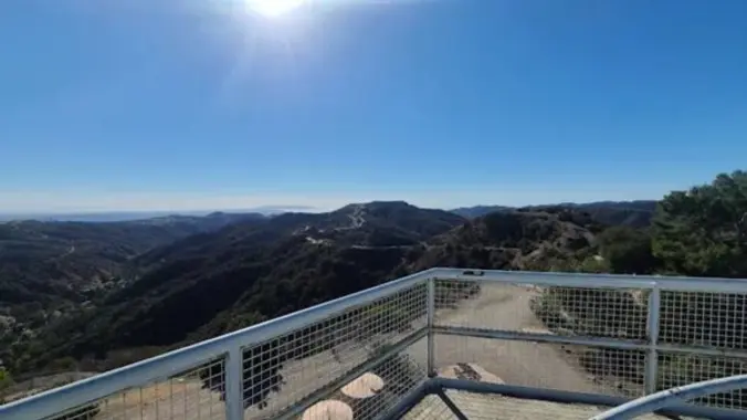
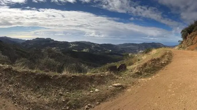
This hike starts at the Satwiwa Loop Trail from the parking lot to the Upper Sycamore Overlook. We will continue hiking the Hidden Valley Overlook Trail to the great view of the HIdden Valley. Then, we will go around the top area and make our way back to rejoin the other side of the Satwiwa […]
This hike will be about 5.4 miles total with 820 ft. of elevation gain. We are starting at the parking lot at the Wahoo's parking lot. We will take Live Oak Trail. This turns into Serrano Road which will take us to Serrano Cow Trail. At this part of the trail, we usually see a […]
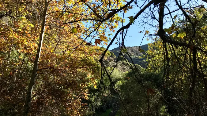
There may be more than one hike posted for Thursday – please only sign up for one! And if you can’t make it, please cancel as early as possible so waitlisted folks can get notice and attend. As of New Year's Day, there were about a half-dozen creek crossings on this route, all of which […]
3.5 miles, 600' gain, Easy Intermediate Easy Option: 2.4 miles, 285' gain, Fit Beginner We enter the Los Padres trail through a spooky oak covered section, then move through until we come to a dead end. We'll turn right, and continue climbing up. We'll come to another junction, where we'll turn right onto the Los […]
**Must also register here: https://letsgooutside.org/activities/2024/01/13/agua-chinon-and-the-sinks-exploration-18/ Will update with more specific trails and distance soon. Start your weekend off by exploring the Agua Chinon wash and the Sinks through this self-guided opportunity. Designated trails will be open for self-guided trail use in OC Parks’ Irvine Ranch Open Space. Trail routes vary in distance and level of […]
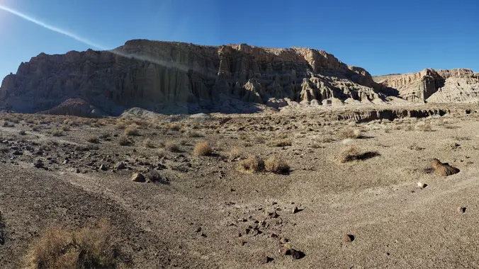
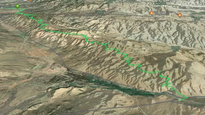
Saturday, January 13, 2024 - ALL DAY HIKE - Ridge Loop through Nightmare Gulch, Red Rock Canyon, Cantil CA - a FULL DAY DESERT ADVENTURE (Weather Permitting) Hike leader volunteers: Paul H, Gary S., Dianne H. Hiking Distance: ~9 miles (Level 3/Intermediate difficulty) Rating: Moderate ++/ Strenuous (experienced/qualified hikers only) Gain/ Loss: ~ 1250' / […]
I'll be modifying a difficult hike and making it a medium one this time. We begin in the prestigious gated neighborhood of the Indian Springs Estates in Chatsworth. From there we head north and enter Indian Springs Open Space, set within the backdrop of surrounding open and untouched mountains, ravines and hillsides. After a little […]
We are going to be starting at the Canyon View Staging Area. This hike will be about 6.2 miles with around 1,000 ft. of elevation gain. We will be starting at Canyon View Park and taking Cholla up to West Ridge and comic down Mathis. Link to Parking from Google Maps: https://www.google.com/maps/place/Canyon+View+Staging+Area/@33.585273,-117.7465062,17z/data=!3m1!4b1!4m5!3m4!1s0x80dce61b6bd45c2d:0x5ef3f1ad687cc8b5!8m2!3d33.585273!4d-117.7443175 Dogs are not […]
This hike will be about 5.4 miles total with 820 ft. of elevation gain. We are starting at the parking lot at the Wahoo's parking lot. We will take Live Oak Trail. This turns into Serrano Road which will take us to Serrano Cow Trail. At this part of the trail, we usually see a […]
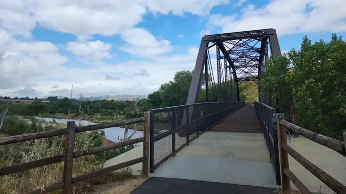
A Sunday morning bike ride (most on bike paths) that is 26 miles long with 600 feet total ascent. Highlights along the way: The star of this tour is a 1898 railroad trestle bridge. The bridge was placed in its current location after the St. Francis Dam disaster in 1928. The railroad bridge that originally […]
This hike starts at Castillo Trail to Wildwood Park. Currently, it’s spectacular with an abundance of mustard greens, wildflowers and California poppies in addition to bountiful water in the waterfalls and creeks. Wildwood Park in Thousand Oaks is one of the most versatile local parks with 27 miles of trails skittering through this area, which […]
We will head up and down in this jaunt to Eagle Rock, following the Garapito trail into the canyon and then up the hill to our destination. We will return via the fireroad. Or we'll do the whole thing in reverse. It willl be a game time decision. I have not personally done this trail […]
5.75 miles, 700' gain. Easy Intermediate. Do not park on Potrero else risk getting a ticket. You need a permit to park on this street. This hike is a great trail when it might be muddy because almost the entire hike is on an asphalt path through a huge state park (> 20 sq miles). […]
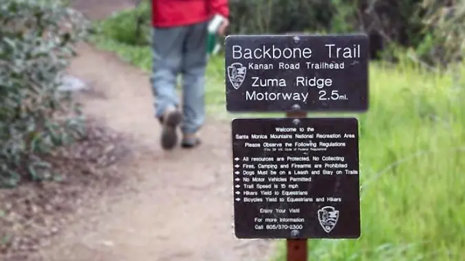
Down and up and down, and then up and down and up. We will hike out and back on the Backbone Trail from Latigo Canyon, across Castro Crest and descending into Upper Solstice Canyon. 2.7miles out, 2.7 miles back. Elevation gain is about or under 1050 ft. Trail is single track almost all the way. […]
The total distance for this hike is 4.5 miles with about 650 ft. of elevation gain. There are great mountain and ocean views along the ridge. We are going to start on Bommer Ridge Trail and take this to Lizard Trail. We will go down that and loop back up to Bommer via Upper Laurel. […]
3 miles, 650' gain, Fit Beginner Easy option, 1.4 miles, 450' gain, Fit Beginner The address given, is not the address of the hike. It is a nearby address that may cause your GPS to drive past the trailhead. Those that prefer the Easy Option, should head UP from the trail head, waiting when they […]
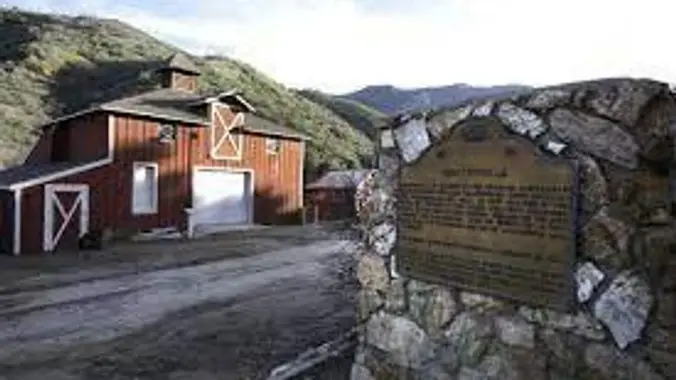
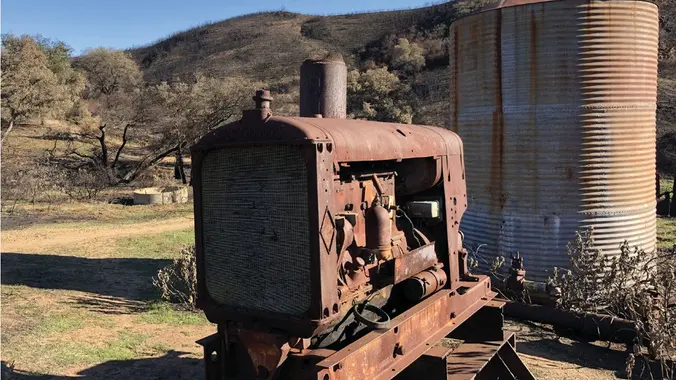
DESCRIPTION: We'll start from Mentryville (a historic SCV site) located at the base of Pico Canyon’s slopes, Mentryville was an 1880’s oil boom town built around its oil well, Pico No. 4. Named for Charles Mentry, historic buildings still stand including a thirteen-room mansion, a one-room schoolhouse, and a barn. Mentryville and Pico No. 4 […]
The hike we will be doing is approximately 5 miles with 870 ft. of elevation gain. We will begin at the Live Oak Trail trailhead. This is where you will see on the map that the Live Oak Trail hits the paved road. This is the parking lot closest to the Edna Spaulding Trail. (There […]
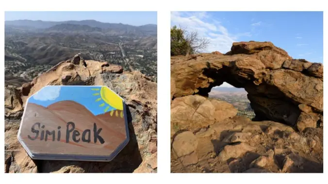
This hike was requested by the original Mark E🙋🏻♂️. Perched 2,000 feet above sea level in the hills between Simi Valley, Oak Park and Thousand Oaks, China Flat is an idyllic 1,100-acre oak meadow that features rocky sandstone outcroppings and native oak woodlands. Along our route we will pass by an old cistern, a small […]
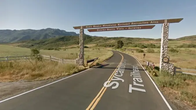
The overflow for the 9 AM hike is overflowing, so try this earlier, shorter hike. It starts at 8:30 and will take the left fork, which goes to the slightly closer Ranch building. Everything else is the same: meet at the RSV parking lot near the bathrooms. Because of this weekend's rain, we will avoid […]
Because of this weekend's rain, we will avoid mud as much as possible with an asphalt / gravel route. We'll meet near the bathrooms in the Rancho Sierra Vista parking lot, then hike down Sycamore Canyon and then take a right onto Ranch Center Road out and then returning on Sycamore Canyon back to the […]
Let's hike at the Back Bay in Newport. The plan is to do 4-5 miles. It will be an out and back. A lot of the trail is asphalt. You can wear hiking or running shoes. There is a Upper Newport Back Bay Nature Preserve parking lot right off University Dr. and Irvine Ave. (See […]
PLEASE NOTE THE PARKING/MEETUP LOCATION ABOVE (IT'S NOT WENDY & POTRERO). Do not park on Potrero Road as it is for residents only. Take a right at the stop sign on Potrero Road and park on Pinehill Avenue or Greenwood Street. Remember to bring a flashlight or a headlamp. Due to the rains we will […]
www.wildernesstravelcourse.org We have a few spaces left in our Long Beach Class for the Wilderness Travel Course. Learn new skills like hiking, backpacking, navigation, bouldering, snow travel, and everything in between. Taught by a team of volunteers, this is a ten session class with 4 outings. We will take you to local hikes, Joshua Tree […]
This hike will be about 5.4 miles total with 820 ft. of elevation gain. We are starting at the parking lot at the Wahoo's parking lot. We will take Live Oak Trail. This turns into Serrano Road which will take us to Serrano Cow Trail. At this part of the trail, we usually see a […]
We're On the Road Again to avoid the mud. This is an earlier, shorter and probably slower hike than the 9 AM one, heading towards the Danielson Ranch Multi-use Area. Everything else is the same: meet at the Rancho Sierra Vista/Satwiwa parking lot near the bathrooms. This out and back hike will be about 6 […]
Once again (again!) because of this week’s rain, we will avoid mud as much as possible and protect out local trails with an asphalt / gravel route. We'll meet near the bathrooms in the Rancho Sierra Vista parking lot, then hike down Sycamore Canyon to the Danielson Multi-Use Area, then returning on Sycamore Canyon back […]
Ski Downhill or Snowboard on Mammoth Mtn. Daily backcountry ski tours and snowshoe tours with the leaders. XC Ski or Snowshoe on your own at Tamarack Nordic Center. Learn to cross-country ski in the backcountry with our instructors (notify Reservationist for free lessons). Newcomers & non-skiers Welcome. Tons of stuff to do in Mammoth in […]
I’m very excited to plan another hike up to the Hollywood Sign and the Bronson Caves. This will take us to the summit of Mt. Lee where we will get the best views of the Hollywood Sign. The total mileage for our journey will be approximately 7 miles. Our elevation change should be about 1,200 […]
Hike #1 in the 2024Saturday in the Santa Monica Mountains, is a moderate 8 mile, 900’ gain out and back hike starting at Paramount Ranch and hiking into Malibu Creek State Park with lunch at the MASH site and return by different trails with views of Malibu Lake as we head back. Bring water, snacks, […]
***** RAIN OR SNOW FALLING AT TRAIL-HEAD CANCELS THIS HIKE ****** Summary: This is a moderately challenging 6-1/2 mile Level 3 (Intermediate) loop hike with 1620 feet of elevation climb. We'll hike at a moderately brisk 2-1/2 mph pace, taking about 3-1/2 hours to complete including a 20 minute snack break at the Coquina Mine […]
Another HWD Original! My Bell Canyon Loop starts and ends at the mouth of Bell Canyon. Its a little-known loop and I haven't seen any other meetup group do it -- so you are in luck today! I've redesigned the hike so if you have done this with me in the past you can look […]
The hike will be about 4.5 miles with about 500 ft. of elevation gain. We will start on Peters Canyon Trail and take this to East Ridge View Trail. This is where we will go up Big Red. Then we will continue on this trail until we get to Eucalyptus to loop back. We will […]
INFORMATIONAL POSTING -35th Annual Beginning Backpack Class Have you ever wanted to learn to backpack and get away from the crowds of people? Learn how to backpack in 3 Saturday courses (4/27, 5/4, 5/11) culminating in a backpack 6/1-2. Course times are 10:30 AM - 2:30 PM Learn what to take, latest in equipment, what […]
This hike begins from the top of King James Court, a cul-de-sac off Lindero Canyon Road. Begin up the trail at the top of the road, passing through a gate by a sign that reads “China Flat Trail Head.” It will pass through the branch of Suicide Trail and another branch of China Flat Trail. […]
Join us on an out and back hike up the Ray Miller Trail and the Overlook Trail. We’ll enjoy beautiful ocean views as we descend. We'll pick up about 1300’ gain on this 7 mile adventure. Lying along the brilliant blue Pacific Ocean at the west end of Malibu (just shy of Port Hueneme), the […]
NOTE: This is an alternative hike for Tuesday, a little slower. We will take the Los Robles East trail with lots of trees and shade. We will do an in/out of 5 miles with about 800' of total elevation gain, spread out nicely. "Robles" is Spanish for oaks, and we'll see plenty of them on […]
This hike will be about 5.4 miles total with 820 ft. of elevation gain. We are starting at the parking lot at the Wahoo's parking lot. We will take Live Oak Trail. This turns into Serrano Road which will take us to Serrano Cow Trail. At this part of the trail, we usually see a […]
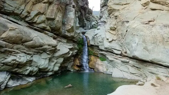
http://photos1.meetupstatic.com/photos/event/b/a/2/4/event_99467652.jpeg Rain is predicted for late night. If it is expected to arrive earlier, the hike will be canceled. Hoping the waterfall will be flowing. From the Kanan Rd trailhead, we'll jump on the Backbone Trail for a cruise down into Newton Canyon. On our way there, we'll cross the creek, pass under an oak […]
COLD WEATHER BACKPACKING!! ****THIS TRIP MAY BE RESCHEDULE DO TO WEATHER CONDITIONS*** Difficulty level: Intermediate Weather: The weather can be unpredictable. Night time temperatures can range from mid 20’s to mid 30’s. NO PLUS 1 Distance – 10 miles round trip Peak Elevation: 10,834 Elevation Gain/Loss: 800-2000 Terrain Type – Snow Difficulty – Intermediate At […]
DESCRIPTION: I discovered this is an old club favorite after looking through the last five years of hikes. It’s an out-and-back trail that is popular for birding, hiking, biking and running, but should not be too busy during our trek (I hope). Dogs are welcome but must be on a leash. It also happens I […]
This hike will be about 7 miles with about 700 ft. of elevation gain. We will start the hike at Cañada Vista Park. From here we will take the Tijeras Creek Trail to the Arroyo Trabuco Trail and use this to loop back to where we started. There will be a few water crossings, so […]
The hike I am planning is around 6.3 miles with about 700 ft. of elevation gain. It starts at the very end of the paved road, the long gray strip that can be seen on the map. We will begin at the Bell Canyon Trail head. We will continue onto that and then take it […]
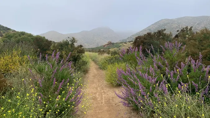
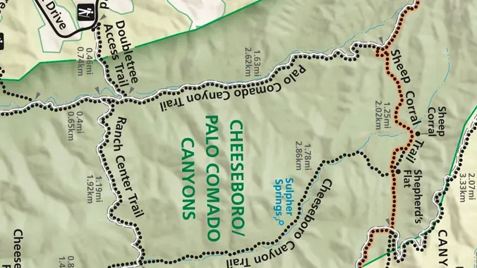
The Morrison Ranch Trail is a unpaved service road beginning at Las Virgenes Road and heading up to Cheeseboro Ridge. We'll traverse oak savannas and a nice walnut woodland getting to the ridge. We'll take a break atop Mount Basura, overlooking Cheeseboro Canyon. We'll descend into Cheeseboro Canyon via the Canyon View Trail and make […]
Let's hope that the weather permits a great hike! Fit Beginner 4.3 miles, 480' gain. Easier Option: 4 miles, 230' gain. We walk a mostly flat section for 1.1 mi. to the 2nd junction. Easier option: Continue straight for 3/4 mi., left at the split, right after another 500', arriving at some picnic tables on […]
Trail statistics are approximate. For safety purposes always assume they are underestimated. But don’t be disappointed if they are overestimated. Bring more water and snacks than you think you’ll need.
Trail descriptions are based on previous hikes. Current conditions are unknown until arrival. Expect the unexpected and plan accordingly.
The Organizers and members of Hiking With Dean are not professional leaders, guides, or mountaineers. The function of the member or organizer is only to organize the trip. Each person who shows up for a trip/meetup (and their guest or guests) is responsible for his or her own safety. By attending a hike, or any other event organized by this group, you are acknowledging that you and any guests that you bring are aware of the risks, dangers and hazards associated with the activity and freely accept and fully assume all such risks, dangers and hazards, and further agree to release and discharge the Organizers, Members of the Hiking With Dean Meetup Group from and against any and all liability arising from your participation in the group activities per our ASSUMPTION OF RISK AND LIABILITY WAIVER and Section 6.2 of the Meetup.com Terms of Service.


Recent Comments