

Let’s hope that the weather permits a great hike!
Fit Beginner 4.3 miles, 480′ gain.
Easier Option: 4 miles, 230′ gain.
We walk a mostly flat section for 1.1 mi. to the 2nd junction.
Easier option: Continue straight for 3/4 mi., left at the split, right after another 500′, arriving at some picnic tables on the right after another 750′.
Regular route: Left, heading up a switch back. Right at the top, and continue for 3/4 mi., turning right where it ends. Head down to the bottom, left at the split. After 750′, we arrive at some picnic tables on the right.
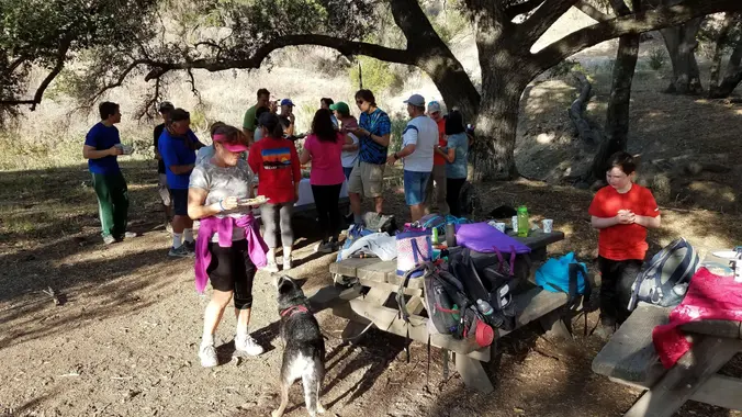
This is a pot luck picnic. Please bring something to eat and drink to share. If your item requires it, bring plates and utensils to share. You may wish to bring your own cup, plate, and utensils in case there aren’t any. Pot Luck guidelines Link
We’ll share snacks and drinks for 60-90 minutes, then return by a straight path, no turns.
Fun Facts
What is MTB?
Answer: Mountain Bike (not Mountain Terrain Bike)
The name I see on a map is: Chesebro Canyon MTB Trail
Why is it spelled Cheeseboro Canyon, Chesebro Canyon MTB Trail, and Chesebro Rd?
The original owner of the land in the late 1800s was Oscar Cheesebrough. The NPS adopted the U.S. Geological Survey spelling of Cheeseboro, while Caltrans adopted the name Chesebro.
Reference Link
Hosting
Route
The host knows the route. A pic of the route has been posted as part of this description. The host may vary the route slightly.
Navigation: Host memory, enhanced by GPS navigation as needed.
Hike type: Social.
We won’t be hiking at a fast pace because this is a social hike, not a conditioning hike. There is nothing wrong with stopping, even if it means every 50 steps.
Stops:
We will stop at junctions to make sure everybody makes any turns, else something will be used to mark the direction.
Each hiker is responsible for knowing their capability, only attending events where they are able to sustain the described pace, for keeping up with the group sufficiently enough to make the turns and not get left behind.
Interesting Notes
Here are a couple plants you are sure to see on this hike:
Black Sage
Multiple brown buttons going up the top of the stalk, that may have white flowers. Green leaves. Purple or white flowers that are dark brown as they dry on the plant. Squish the leaves and smell.
A rare and sought after Black sage honey is also made from the honey of bees that pollinate the Black sage plant. Black sage is utilized in the culinary world as an aromatic and flavorful herb. It can be used in recipes wherever traditional sage is called for, however keep in mind that foraged Black sage has a much stronger flavor than that of traditional store bought sage.
Its flavor goes well with winter squashes, brown butter, poultry, venison, pears, cheese, potatoes and other herbs such as rosemary and thyme. Use fresh in a variety of different preparations or leaves. Can be dried and stored for future use as a dried herb.
Black sage was used traditionally by Native Americans known as the Chumash people to form an herbal soak for the bath to be used in the treatment of bodily pain, specifically for the feet and lower legs.
Other
Dogs allowed? Yes
Directions
Chesebro Canyon MTB trail
5402 Chesebro Rd, Agoura Hills, CA 91301
From I-101:
Exit Chesebro Rd..Palo Comado Canyon Rd.
Continue north. It becomes Palo Comado Canyon Rd and rotates west.
Right at Chesebro Rd. for 0.4 miles.
Park on the street.
After the 1 lane bridge, you’ve gone too far.
FAQ
Hiking Plus Page Links
Disclaimer / Release of Liability


