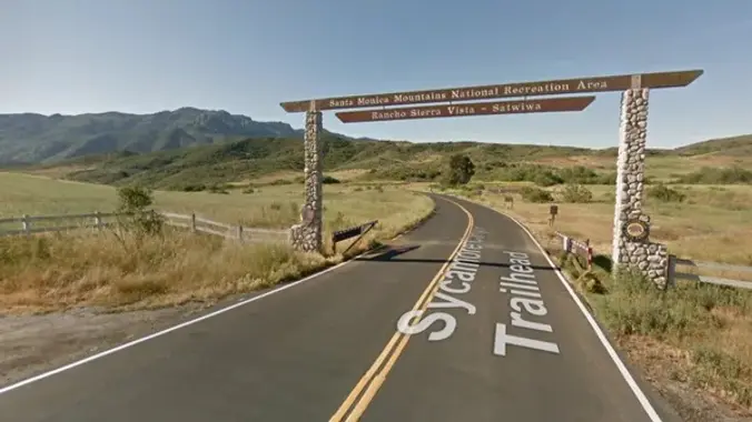
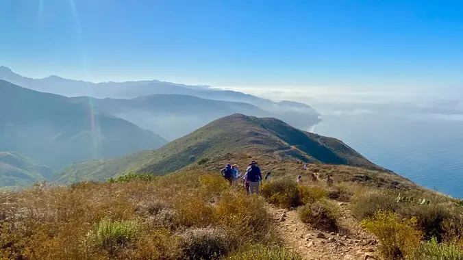
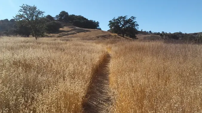
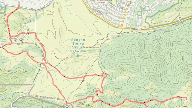
This hike will be an 8-figure of two loops starting at the Satwiwa Loop Trail from the parking lot. Then, we will continue hiking the South Ridge Trail on the other side and back to the parking lot through the Ranch Overlook Trail. "Satwiwa" is Chumashan and directly translates to "the bluffs," which can also […]
UPDATE: Please review our guidelines to participate in our hikes. Here are some highlights and a link to the guidelines: https://www.meetup.com/The-Weekday-Trailblazers/about/ Restrictions apply for your safety and ours: Don't show up unless you're on the "Attending" list No "Plus Ones" on this hike Plan on completing the entire hike at a reasonable pace or please […]
3.0 miles, 800' gain, easy-intermediate. This hike is rated easy-intermediate because it is a continuous incline for 1.5 miles. This isn't real steep, but it is continuous, and many beginner hikers have indicated this should be rated intermediate. That said, there is no reason a fit beginner cannot complete this hike. If needed, just stop […]
Time to explore more of Yosemite! This trip goes over a Rodgers Pass which is a cross country route (NO TRAIL). From what I read it is a giant pile of loose rock (aka scree). The Route Rodgers Pass Info 41 miles 9500 feet Current plan: Day 0 (Tuesday): Camp at one of the campgrounds […]
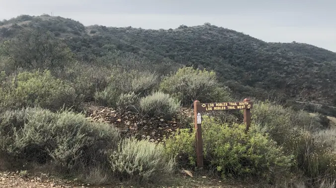
https://a248.e.akamai.net/secure.meetupstatic.com/photos/event/4/5/b/c/event_52757852.jpeg Don't show up unless you're shown on the "Attending" list Unregistered or waitlisted will be turned away No "Plus Ones" on this hike Time to re-explore the Los Robles trail system! This will be a 6 mile salt water taffy hike with approximately 1000 feet of elevation gain. We start at the trailhead at […]
This trip starts from Kearsarge Trailhead and will and Whitney Portal via the JMT/PCT trail. Short video of the route. BEAR CANISTERS ARE REQUIRED Days: 4-5 Days Rating: (Moderate/Strenuous) Milage: 45 + Elevation Gain/lost: +10,755 ’/-2400″ Location Start: Kearsarge Trailhead Location end: Whitney Portal MAP >>> Itinerary (updating soon) Simple Rules NO PLUS (1) $15 […]
This hike will be about 5.4 miles total with 820 ft. of elevation gain. We are starting at the parking lot at the Wahoo's parking lot. We will take Live Oak Trail. This turns into Serrano Road which will take us to Serrano Cow Trail. At this part of the trail, we usually see a […]
3.25 miles out and back, 600' gain, Easy Intermediate. Many people will be viewing the fireworks from this location, and enjoying a picnic at the top. Easier Option (unhosted): 2.4mi, 550' gain. (link to map). 497 Hillsborough St, Thousand Oaks, CA 91361 We'll start by entering the Los Padres trail, through a spooky oak covered […]
The total distance for this hike is 4.5 miles with about 650 ft. of elevation gain. There are great mountain and ocean views along the ridge. We are going to start on Bommer Ridge Trail and take this to Lizard Trail. We will go down that and loop back up to Bommer via Upper Laurel. […]
Fit Beginner - 4 miles, 600' gain The gain is well distributed, with half being on the return. We start at the Las Flores trailhead where Las Flores dead-ends at Wildwood Park, and head west. After 1/3 mile, the trail becomes Wildwood Canyon Trail. We continue for another 2/3 mile and cross a bridge just […]
This hike circles the trails between South Ranch and Conejo Ridge. This is about 6 miles (1000 foot elevation gain) lollipop. We will start at the trailhead at Triunfo Park's back (2nd) parking lot, go up to the Los Robles trail and turn left on the Whitehorse trail. We then loop around counterclockwise via the […]
This hike circles the trails between South Ranch and Conejo Ridge. This is about 6 mile (1000 foot elevation gain) lollipop. We will start at the trailhead at Triunfo Park's back (2nd) parking lot, go up to the Brookview/Los Robles trail connector. We then loop around clockwise via the White Horse and Los Robles trails […]
5.75 miles, 700' gain. Easy Intermediate. Do not park on Potrero else risk getting a ticket. You need a permit to park on this street. This hike is a great trail when it might be muddy because almost the entire hike is on an asphalt path through a huge state park (> 20 sq miles). […]
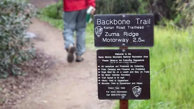
http://photos1.meetupstatic.com/photos/event/b/a/2/4/event_99467652.jpeg Due to the heat, we will not go all the way up to the peak. From the Kanan Rd trailhead, we'll jump on the Backbone Trail for a cruise down into Newton Canyon. On our way there, we'll cross the creek, pass under an oak canopy, and come out into an opening. At the […]
This hike starts at the Rancho Sierra Vista parking lot, goes down to the bridge on Sycamore Canyon asphalt, but then turns up the canyon alongside Upper Sycamore Creek. Along the way, we'll be in the shade of Boney Mountain while we climb, doing a handful of easy water crossings and finding a number of […]
This popular trail is located near the Irvine turtle rock neighborhood. It is a 4.2 mile loop with 900 ft elevation gain. It takes around 2h to complete at a moderate pace. We will park on the street which is next to the Turtle Rock Preschool. The trail starts with a steep climb for about […]
5.2 miles, 1140' gain, easy-intermediate. Warning: Google Maps may take you to the incorrect location, although the address is correct. Please follow the written directions. The hike starts completely flat along a gravel track that moves around the Dos Vientos Community park. It then gently rises into the surrounding hills, continuing onto the Powerline trail. […]
The hike we will be doing is approximately 5 miles with 870 ft. of elevation gain. We will begin at the Live Oak Trail trailhead. This is where you will see on the map that the Live Oak Trail hits the paved road. This is the parking lot closest to the Edna Spaulding Trail. (There […]
Hike #8 in the 2024 Saturday in the Santa Monica Mountains series, a strenuous 12 mile, 2000 gain out and back hike from Bark Park to King Gillette Ranch. We will start on the New Millenium Trail then take the Las Virgenes View Trail over to brunch at Gillette Ranch. Bring water, snacks, sunscreen, and […]
Save the date, more details will follow! Come buy, sell, or exchange your used hiking, camping, climbing, and snow gear. Meet like-minded outdoor enthusiasts Watch a backpacking cooking demo Share a picnic with your new friends (after the gear sale)
The hike will be about 5.7 miles with about 750 ft. of elevation gain. We will start on Peters Canyon Trail and take this to East Ridge View Trail. This is where we will go up Big Red. Then we will continue on this trail until we get to Eucalyptus to loop back. We will […]
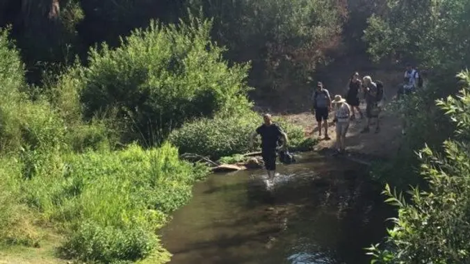
This hike is the perfect summer hike. It will require several stream crossings along the Arroyo Conejo and Wildwood Canyon Creek so wear shoes you don't mind getting wet (if you don't like walking on rocks); shorts recommended We'll visit the Wetlands and have a picnic lunch at shady Skunk Hollow, a tree-lined area adjacent […]
Easy-Intermediate, 4 miles, 800' gain. Option not to hike: If for some reason you don't want to hike but still want to come, the social event can be driven to, and the main group of hikers should get there about an hour after we begin: 23601 W Red Rock Rd, Topanga, CA 90290. It costs […]
Tomorrow’s weather forecast for Thousand Oaks is the mid 60’s to low 70’s after it’s been under an extreme heat wave the last few weeks. Let’s hike from Gold Canyon Trail to Wildwood park. It will pass through various trails with a long creek, crossing streams and bridges, Indian caves, volcanic rock cliffs, waterfalls, cacti-filled […]
This hike will be the FASTER and EARLIER of the Tuesday hikes. Let's do the Ray Miller trail to the fire road. Thanks Nancy for the convenient write-up! The trail is an awesome blend of ocean and mountain views in Malibu’s La Jolla Canyon. We will start from the trailhead which follows the canyon eastward, […]
This hike will be the slower of the Tuesday hikes. Let's do the Ray Miller trail to the fire road. The trail is an awesome blend of ocean and mountain views in Malibu’s La Jolla Canyon. We will start from the trailhead which follows the canyon eastward, away from the ocean. Then, it quickly brings […]
http://photos2.meetupstatic.com/photos/event/b/0/e/c/event_80025292.jpeg Since the trail has been redesigned and is now about 8 1/2 miles, we will stop at Ventu Park Road for our break. PLEASE NOTE: Don't show up unless you're shown on the "Attending" list Unregistered or waitlisted will be turned away No "Plus Ones" on this hike This is a moderately strenuous 7+ […]
From the Kanan Rd trailhead, we'll jump on the Backbone Trail for a cruise down into Newton Canyon. On our way there, we'll cross the creek, pass under an oak canopy, and come out into an opening. At the opening, look toward the sandstone formations in the distance, and you'll see the now-maybe-flowing Upper Newton […]
This is also a gentler hike for Thursday starting at Newton Canyon, another group is starting at 8:30 and going down the backbone trail. We will go up and cross over Kanan and hike to Latigo. Please only sign up for one hike. This hike is only 5 miles and will take us on a […]
5 miles, 500' gain, Beginner This hike is a great trail for beginners because all the elevation gain is distributed. It is a walk down a rolling fire road through a really cool canyon, and you will find no difficult or extended elevation climbs. This is one of my favorite trails for people new to […]
The hike I am planning is around 6.3 miles with about 700 ft. of elevation gain. It starts at the very end of the paved road, the long gray strip that can be seen on the map. We will begin at the Bell Canyon Trail head. We will continue onto that and then take it […]
DESCRIPTION: Our hike starts at Viola Fields in Carpinteria. The trail takes us to Rincon Beach. Along the way we pass great views of the Pacific Ocean shore line. We descend down to the shore and enjoy a light ocean breeze as we walk on the sand. Return to the bluffs and watch the hang […]
Fooz Fighters Many of us from this group will attend this event. Please bring food and drinks to share. If your item requires utensils, please supply them. Concert starts at 6:30p. About the band - click here Free parking available on-site. Overflow parking is on the softball fields, off Thompson. Dogs on a leash are […]
The total distance is around 4.6 miles with 870' of elevation gain. We will take Boat Canyon Trail up to Bommer Canyon. We will take Bommer to Water Tank trail. We will take this and then take a lower trail back to the beginning. Address: Dartmoor Trail Lookout Laguna Beach, CA 92651 https://goo.gl/maps/6N8c88XfdSeYu85M8 Dogs are […]
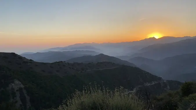
3.0 miles, 800' gain, easy-intermediate. Moonrise 8:51 pm Photo Credit to Helen :) Let's enjoy the gorgeous sunset and the almost full moon, and fun loaded potluck picnic at the beautiful Angel Vista! This is a potluck hike. Please bring food, drinks to share. If your item requires utensils/plates/toothpicks, etc., please bring them. You may […]
Just off the ocean, Sycamore Canyon is a wide, seemingly flat stroll among grasses, wildflower, and sycamore trees, surrounded by mountains on both sides. Rather than letting that lull you into a false sense of complacency, we'll take a left turn just after we start, and hike up the southern fork of Overlook Trail to […]
Fit Beginner, 4.1 miles, 720' gain. Easier route: 3.9 miles, 500' gain. Is it Talepop or Talopop? Maps and signs that I have seen, use the 2nd spelling, but a lot of references use the other. We'll head behind the facilities building in the center and head left down the Las Virgenes Trail. After 1/3 […]
Fit Beginner - 4 miles, 600' gain The gain is well distributed, with half being on the return. We start at the Las Flores trailhead where Las Flores dead-ends at Wildwood Park, and head west. After 1/3 mile, the trail becomes Wildwood Canyon Trail. We continue for another 2/3 mile and cross a bridge just […]
The headlands, cliffs, trails, and beaches of 63-acre Point Dume State Beach and Point Dume Natural Preserve make an exciting location for a day of exploring. Cliffs provide places for birds to roost. Over 100 types of birds are found here. Watch the sky for brown pelicans, falcons, and hawks. Other animals roam the park, […]
Will keep an eye on the temperature. If it is expected to be above 90 at the time of the hike, I will cancel it. As this is an Out and Back slower paced hikers can go as far as Latigo Canyon and turn around for a total of 4.6 miles, or we can pick […]
Read or listen to: Deep Survival, Who lives, Who Dies, And Why. by Laurence Gonzales Examining stories of miraculous endurance and tragic death, how people get into trouble and how they get out again (or not)-Deep Survival takes us from the tops of snowy mountains and the depths of oceans to the workings of the […]
Folks have asked to change the hike on Thursday to start at 8:00 because of the heat and I think that is a good idea, so I am posting this hike and will cancel the other one. We will start at the parking area in Hill Canyon, cross the bridge over the runoff creek, and […]
Instead of our usual starting point at the Conejo Playfields, this shorter, gentler hike will start at the top of Camino Magenta, in the beautiful unincorporated Lynn Ranch neighborhood surrounded by Thousand Oaks. We'll do a clockwise loop around the gated Lynnmere community and wind up back at our starting point about 4.5 miles and […]
4.2 miles, 700' gain, easy-intermediate. Easier option: 2.7 miles, 500' gain, fit beginner. This is a pot-luck hike. We'll be stopping at the 3/4 point by a picnic table, so please bring food and drink to share, and any utensils your items might require. You may wish to bring your own cup, plate, and utensils […]
It's always a great time with our Hiking Plus friends! Many from this group, plus other friends, will attend this event at Sagebrush Cantina. Come on out and join your friends, make new ones, and dance to a great 80's band at one of our favorite places. 80's Invasion, led by Dirk Knight and Mony […]
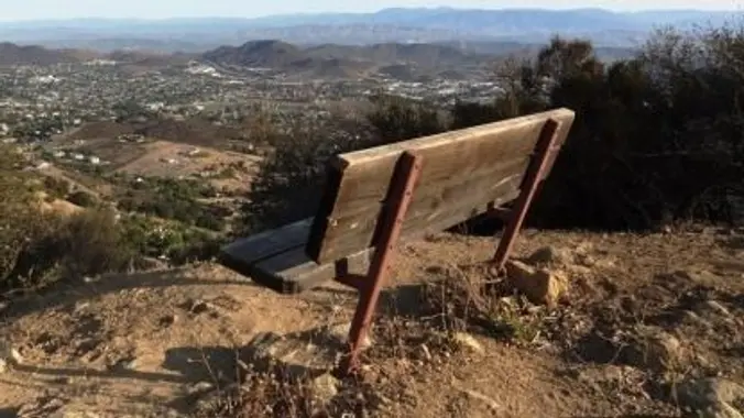
Meet at the trailhead at 8 Pacific time. We will do the loop up the road to the benches and loop back down via the single track. If wanted we can add some additional miles up the ingle track back to the parking lot. 7-9 miles, but you adjust the hike however you want to. […]
This HDW original is a classic. On this 6 mile hike I will take you through Franklin Canyon and then a bit off-trail to the "planar" center of Los Angeles. It will make a great photo opp. The first hill will be a workout, but there is lots of shade on this one. Franklin Canyon […]
Details Distance/ Gain: The hike is a 6-mile loop with about 1200 feet of gain. Rating: Moderate + (mainly for distance and altitude). Description: Mt Waterman is better known as a ski area in the San Gabriel Mountains off Highway 2. It recently was hit by the Bobcat fire and is just now starting to […]
We will meet at the main parking lot. We willWe will meet at the main parking lot. We will be doing the Santa Rosa trail, hike up to lizard rock then work our way back to the parking lot. EST 7ish miles
This hike will be about 7 miles total with 1200 ft. of elevation gain. We are starting at the parking lot at the Wahoo's parking lot. We will take Live Oak Trail. This turns into Serrano Road which will take us to Serrano Cow Trail. At this part of the trail, we usually see a […]
Let's head out to the famed Peace, Love, Joy arch at the Danielson. This out and back hike wanders through grasslands and chaparral from the Rancho Sierra Vista trailhead, then climbs up Danielson fire road for some fantastic views north to Port Hueneme and Oxnard and west toward the Pacific Ocean. If it's really clear, […]
Due to the summer heat and humidity this is a choose your own hike. You have the option of 6 or 8 miles. It’s a straight forward out and back hike so you decide when to turn back. Encinal Canyon is named for encina, the Spanish word for the holm oak, a lovely Mediterranean tree […]
4 miles, 700' gain, easy-intermediate Easy option: 2.5 miles, 500' gain Parking on the south side of the CA-118 at the Rocky Peak exit. We'll walk west along the Santa Susana Pass Rd. for about 500 feet, and directly across from Lilac Ln, we'll enter a trail. We'll move along a relatively flat section for […]
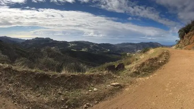
*PLEASE* read the directions to the different parking location. We generally get into Rancho Sierra Vista either through the RSV parking lot, or the dusty lot at the end of Wendy Drive. This time, we'll access it through a seldom-used "back door" in the neighborhood south of Lynn Road. We'll loop through the NPS ranger […]
Meet at the Rosewood sign, which is at the Regal Oak Ct. and Lynn Rd. intersection. The hike is about 5 miles with an elevation gain/loss approximately 900’. We'll walk up to the lower Rosewood Trail, then take the dirt trail up a shaded ravine and continue on the Rosewood trail to the Angel Vista […]
This popular trail near the Irvine Turtle Rock neighborhood is a fantastic hike, featuring a 4.2-mile loop with a 900-foot elevation gain. It's typically completed in about 2 hours at a moderate pace, and street parking is available near Turtle Rock Preschool. The hike begins with a steep climb, gaining 264 feet in just 0.38 […]
My classic Heartbreak Hill loop in the Liberty Canyon Preserve now includes a view of the Wallis Annenberg Wildlife Crossing. Tonight we check out its progress from above! You have 2 options: 0.5 mile with 500 feet ascent takes us to the bridge view. Includes Option 1 and continues for another 5 miles. After an […]
The hike will be about 5.7 miles with about 750 ft. of elevation gain. We will start on Peters Canyon Trail and take this to East Ridge View Trail. This is where we will go up Big Red. Then we will continue on this trail until we get to Eucalyptus to loop back. We will […]
DESCRIPTION: When it’s hot we like to go early, get altitude and/or head to the beach! Hiking Mount Pinos will take you away from the summer heat of SCV, dropping ~20 degrees where you can enjoy alpine views while listening to the breeze gently caressing huge pines. Starting near the Frazier Park sledding location where […]
The total distance for this hike is 4.5 miles with about 650 ft. of elevation gain. There are great mountain and ocean views along the ridge. We are going to start on Bommer Ridge Trail and take this to Lizard Trail. We will go down that and loop back up to Bommer via Upper Laurel. […]
We'll start 5:30 PM to avoid the heat. 3.5 miles, 700' gain, Easy Intermediate. Easy Option: 2.4 miles, 285' gain, Fit Beginner. We'll start by entering the Los Padres trail, through a spooky oak covered section, then move through until we come to a dead end. We'll turn right, and climb up to another junction, […]
Trail statistics are approximate. For safety purposes always assume they are underestimated. But don’t be disappointed if they are overestimated. Bring more water and snacks than you think you’ll need.
Trail descriptions are based on previous hikes. Current conditions are unknown until arrival. Expect the unexpected and plan accordingly.
The Organizers and members of Hiking With Dean are not professional leaders, guides, or mountaineers. The function of the member or organizer is only to organize the trip. Each person who shows up for a trip/meetup (and their guest or guests) is responsible for his or her own safety. By attending a hike, or any other event organized by this group, you are acknowledging that you and any guests that you bring are aware of the risks, dangers and hazards associated with the activity and freely accept and fully assume all such risks, dangers and hazards, and further agree to release and discharge the Organizers, Members of the Hiking With Dean Meetup Group from and against any and all liability arising from your participation in the group activities per our ASSUMPTION OF RISK AND LIABILITY WAIVER and Section 6.2 of the Meetup.com Terms of Service.


Recent Comments