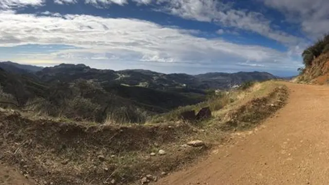
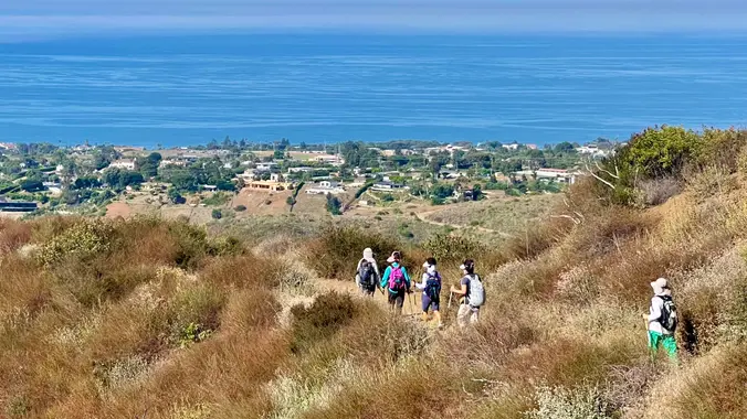
Let's head out to the famed Peace, Love, Joy arch at the Danielson. This out and back hike wanders through grasslands and chaparral from the Rancho Sierra Vista trailhead, then climbs up Danielson fire road for some fantastic views north to Port Hueneme and Oxnard and west toward the Pacific Ocean. If it's really clear, […]
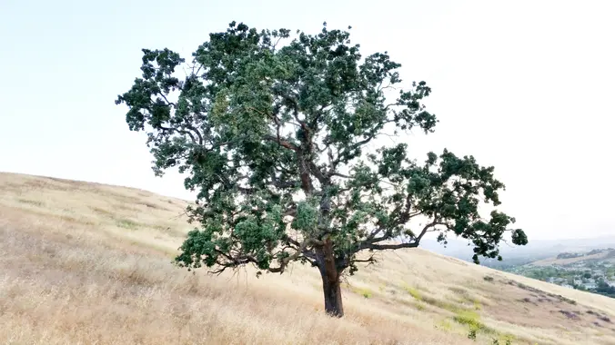
Due to the summer heat and humidity this is a choose your own hike. You have the option of 6 or 8 miles. It’s a straight forward out and back hike so you decide when to turn back. Encinal Canyon is named for encina, the Spanish word for the holm oak, a lovely Mediterranean tree […]
4 miles, 700' gain, easy-intermediate Easy option: 2.5 miles, 500' gain Parking on the south side of the CA-118 at the Rocky Peak exit. We'll walk west along the Santa Susana Pass Rd. for about 500 feet, and directly across from Lilac Ln, we'll enter a trail. We'll move along a relatively flat section for […]
*PLEASE* read the directions to the different parking location. We generally get into Rancho Sierra Vista either through the RSV parking lot, or the dusty lot at the end of Wendy Drive. This time, we'll access it through a seldom-used "back door" in the neighborhood south of Lynn Road. We'll loop through the NPS ranger […]
Meet at the Rosewood sign, which is at the Regal Oak Ct. and Lynn Rd. intersection. The hike is about 5 miles with an elevation gain/loss approximately 900’. We'll walk up to the lower Rosewood Trail, then take the dirt trail up a shaded ravine and continue on the Rosewood trail to the Angel Vista […]
This popular trail near the Irvine Turtle Rock neighborhood is a fantastic hike, featuring a 4.2-mile loop with a 900-foot elevation gain. It's typically completed in about 2 hours at a moderate pace, and street parking is available near Turtle Rock Preschool. The hike begins with a steep climb, gaining 264 feet in just 0.38 […]
My classic Heartbreak Hill loop in the Liberty Canyon Preserve now includes a view of the Wallis Annenberg Wildlife Crossing. Tonight we check out its progress from above! You have 2 options: 0.5 mile with 500 feet ascent takes us to the bridge view. Includes Option 1 and continues for another 5 miles. After an […]
The hike will be about 5.7 miles with about 750 ft. of elevation gain. We will start on Peters Canyon Trail and take this to East Ridge View Trail. This is where we will go up Big Red. Then we will continue on this trail until we get to Eucalyptus to loop back. We will […]
DESCRIPTION: When it’s hot we like to go early, get altitude and/or head to the beach! Hiking Mount Pinos will take you away from the summer heat of SCV, dropping ~20 degrees where you can enjoy alpine views while listening to the breeze gently caressing huge pines. Starting near the Frazier Park sledding location where […]
The total distance for this hike is 4.5 miles with about 650 ft. of elevation gain. There are great mountain and ocean views along the ridge. We are going to start on Bommer Ridge Trail and take this to Lizard Trail. We will go down that and loop back up to Bommer via Upper Laurel. […]
We'll start 5:30 PM to avoid the heat. 3.5 miles, 700' gain, Easy Intermediate. Easy Option: 2.4 miles, 285' gain, Fit Beginner. We'll start by entering the Los Padres trail, through a spooky oak covered section, then move through until we come to a dead end. We'll turn right, and climb up to another junction, […]
We will start to hike the Zuma Loop trail and continue on to Ocean View trail. Then, we descend down the Canyon View trail to the parking lot. The name “Zuma” is derived from the Chumash language and means “abundance.” Ocean and Canyon View Loop Trail is self-evident. Both offer an absolute abundance of breathtaking […]
It is going to be hot on Tuesday, so this is a slower, early, hike up Ray Miller. The trail is an awesome blend of ocean and mountain views in Malibu’s La Jolla Canyon. We will start from the trailhead which follows the canyon eastward, away from the ocean. Then, it quickly brings you back […]
Summer heat is here so let’s get in a 6 mile hike before the temperature get too high. Palo Comado ("Burnt Stick" in Spanish) tells you a lot about the environs - frequently burned over by wildfires, this was directly in the line of the Woolsey Fire but much of the vegetation has re-grown. This […]
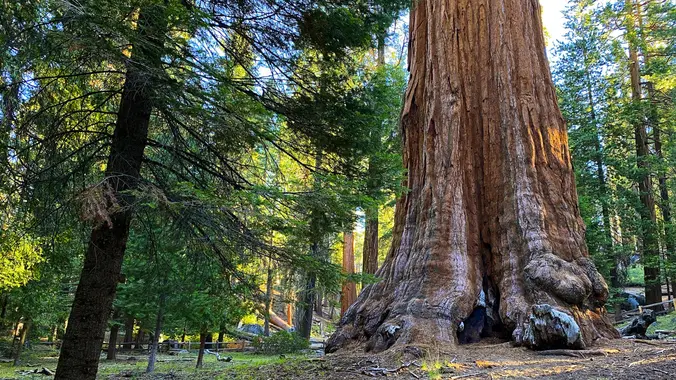
CHC Camping Trip Stony Creek Campground, Sequoia National Forest August 7-11, 2024 36° 39' 54.8820" N 118° 49' 58.0188" W Sequoia National Forest is a beautiful alpine area with some of the largest trees on earth – the giant sequoias. Our campground is near a beautiful natural granite waterslide with swimming holes. Come prepared to […]
Haven't done this hike in over a year. Hoping the marshy area has dried up since we have had no rain in a while. Please read these restrictions before signing up. Don't show up unless you're shown on the "Attending" list Unregistered or waitlisted will be turned away No "Plus Ones" on this hike No […]
Please join us for a hike to the very tippy-top of Conejo Mountain. This 5.0-mile hike has a total elevation gain and loss of 1,100 feet (at least, according to GaiaGPS). Because of the distance, I'm classifying it as a Gentler, but there are some steep spots for which trekking poles may be advisable. Almost […]
NOTE: This will be a gentler hike for Thursday. We will go slower and with less elevation gain and less miles. If anyone wants to add more miles, and someone knows the route, we can take the loop up to the Greenmeadow Parking lot and then back to Moorhead. We will start in the parking […]
4.6 miles, 1000' gain, Easy Intermediate Easier Option - 2.7 miles, 320' gain Many have gotten lost relying on GPS. This is the Wendy Trailhead, where S. Wendy Dr. ends at Potrero Rd. Heading out, we cross a creek, turn right at the split, then Turn right at the dead end. We regroup at the […]
***DATE SUBJECT TO CHANGE TO AUGUST 22-25. Keep both dates open if you want to come on this trip. RSVPs will open APRIL 1. Add yourself to the waitlist and I will manually add on April 1.*** This is a moderately-advanced trip and may be conducted as a through hike or a loop hike, it’s […]
Lisa couldn't host her first permit for this trip so I snagged it when she cancelled :) This is a moderately-advanced trip. Be Prepared for mosquitoes 🦟 It will be HOT because when we hike down to the hot springs because it's at about 7K feet. Containers to prevent Bear access required🐻. This means devices […]
Double peak Cirque and Langley If we have never hiked together I will ask a couple of questions before being added Only taking 3 ppl 2 night and 2 days. If you want more info please DM
Eydie is a Weekday Trailblazers hiker in Newbury Park. This is her event cross-posted from her Meetup group The OM Crystals and Minerals Sales and Events. August 10th & 11th 10:00am - 4:00pm Location: 1749 Oleary Court, Newbury Park 91320 I'm excited to announce another exclusive Crystal & Mineral Sale Event, tailored especially for our […]
Join us for a relatively easy 3.6 mile hike in Charmlee Wilderness Park. Perched on a bluff overlooking the Malibu coast this 590-acre park has 8 miles of interwoven trails offering spectacular ocean views, close-ups with rocky outcrops and shady oak woodlands. I have custom built the hike so we can take advantage of all […]
This hike is so cool! It's a good distance with little elevation gain and it is beautiful. This hike will take us to the Brown Mountain Dam Waterfall. The hike is an out and back at around 8 miles total with 750 ft. of elevation gain, so not steep! This area of the Angeles National […]
Hike #8 in the 2024 Saturday in the Santa Monica Mountains series, is a moderate 10 mile, 1700’ gain lollipop hike from Temescal Park to Inspiration Point in Will Rogers State Park and then unto Murphy Ranch where some participants added the two 500-step stairs up and back to work up an appetite for lunch […]
This hike will be about 7 miles total with 1200 ft. of elevation gain. We are starting at the parking lot at the Wahoo's parking lot. We will take Live Oak Trail. This turns into Serrano Road which will take us to Serrano Cow Trail. At this part of the trail, we usually see a […]
Join us as L.A. Vations (U2 tribute) celebrates and reinvents the timeless music of the legendary U2. Let's enjoy potluck picnic before the music starts at 6pm. Please bring food and/or drinks to share. If your item requires utensils, please supply them. You may wish to bring your own cup, plate, and utensils in case […]
This hike will be Gentler Intermediate and Earlier of the Tuesday hikes! The trail is an awesome blend of ocean and mountain views in Malibu’s La Jolla Canyon. We will start from the trailhead which follows the canyon eastward, away from the ocean. Then, it quickly brings you back toward the ocean at a gradual […]
It looks like cooler temperatures next week but just in case high heat creeps back in, you can choose to do a 5.4 mile hike with about 1000’ gain up the Ray Miller Trail to the fire road or extend the hike to 7 miles by continuing on the Overlook Trail with about 1300’ gain. […]
4.6 miles, 900' gain, easy-intermediate This route takes us through a beautiful canyon via a counter-clockwise lollipop. Most of the hike has a clear view of the sky, with a few parts that have tree cover. We'll be stopping at the half-way point for a snack and beverage share. We'll start at the Palo Comado […]
PLEASE READ BELOW IN ITS ENTIRETY. Kindly review the guidelines (link to the guidelines) to join our hikes. Restrictions apply for your attendance. Don't show up unless you're shown on the "Attending" list. Plan on KEEPING UP with the group and completing the entire hike or please find an alternative hike that better suits your […]
This is not a guided hike. Hike your own hike. I hope to share times I'll be conditioning to offer others the opportunity to come out and do the same. I'll be wearing an SDB shirt and hat so you can spot me. I'll hang out in the parking lot before I start. Hike your […]
NOTE: It is awfully hot out there folks, the only hike I will do is this one because we did it last week and there was lots of shade. This will be a gentler hike for Thursday. We will go slower and with less elevation gain and less miles. Some hikers may want to go […]
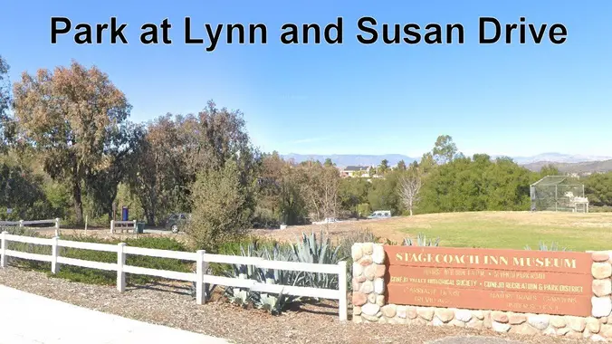
This is a 4-5 mile out-and-back trip from Lynn Road to the Rosewood Trail to Angel Vista. We’ll park at the playfield near Stagecoach Inn and walk from Lynn Road on the lower Rosewood Trail, to the usual trailhead and then on up the trail. The elevation gain/loss is about 875’ - 1000’. It is […]
This popular trail near the Irvine Turtle Rock neighborhood is a fantastic hike, featuring a 4.2-mile loop with a 900-foot elevation gain. It's typically completed in about 2 hours at a moderate pace, and street parking is available near Turtle Rock Preschool. The hike begins with a steep climb, gaining 264 feet in just 0.38 […]
https://www.alltrails.com/trail/us/california/tapo-canyon-trail?u=i Hello Fellow Hikers, ( please read liability disclaimer at the bottom )  Join me on a easier moderate hike at Tapo Canyon Trail in Simi Valley. This hike has a nice gradual walk until we start a gradual climb were we will start our loop. We should encounter wildflowers and mountain views. Our […]
Join us for this up and back hike in Tehachapi Park. This hike doesn’t include the very steep last three quarter mile to the peak. Once we arrive at the junction for the turnoff to the peak there will be the option to go back or continue down the trail for another 1 to 2 […]
The hike we will be doing is approximately 5 miles with 870 ft. of elevation gain. We will begin at the Live Oak Trail trailhead. This is where you will see on the map that the Live Oak Trail hits the paved road. This is the parking lot closest to the Edna Spaulding Trail. (There […]
DESCRIPTION: This is a pleasant uphill hike on the north slope of Blue Ridge. Our trail starts up through stands of scrub oak, black oak, and Jeffrey pine, changing to white fir, sugar pine, and lodgepole pine as we climb the mountain. Views over Table Mt. and San Gabriel East Fork, with back drops of […]
We are going to be starting at the Canyon View Staging Area. This hike will be about 6.2 miles with around 1,000 ft. of elevation gain. We will be starting at Canyon View Park and taking Cholla up to West Ridge and comic down Mathis. Link to Parking from Google Maps: https://www.google.com/maps/place/Canyon+View+Staging+Area/@33.585273,-117.7465062,17z/data=!3m1!4b1!4m5!3m4!1s0x80dce61b6bd45c2d:0x5ef3f1ad687cc8b5!8m2!3d33.585273!4d-117.7443175 Dogs are not […]
3.0 miles, 800' gain, easy-intermediate. Moonrise 7:21 pm Photo Credit to Helen :) Let's enjoy the gorgeous sunset and the almost full moon, and fun loaded potluck picnic at the beautiful Angel Vista! This is a potluck hike. Please bring food, drinks to share. If your item requires utensils/plates/toothpicks, etc., please bring them. You may […]
Zuma Canyon is distinguished for being one of the deepest gorges in the Santa Monica Mountains and unlike Topanga or Malibu Canyons has never suffered incursion by a major road. Our 5.6 mile loop hike begins in a deep cleft of the Santa Monica Mnts., then winds up a mellow ridgeline with gorgeous ocean views, […]
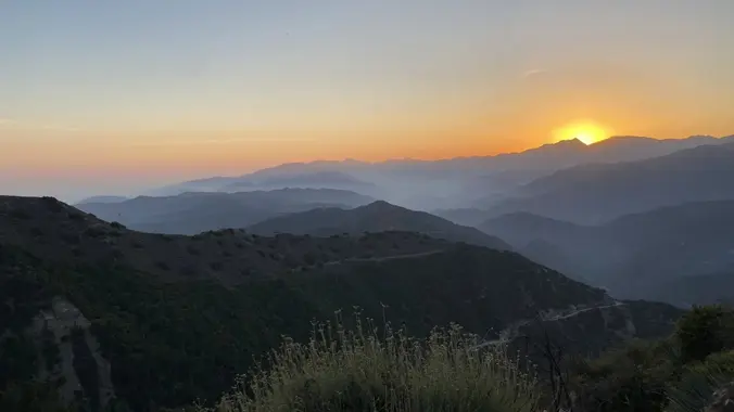
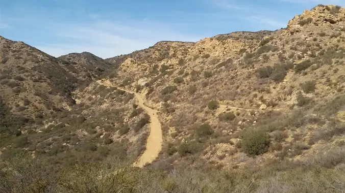
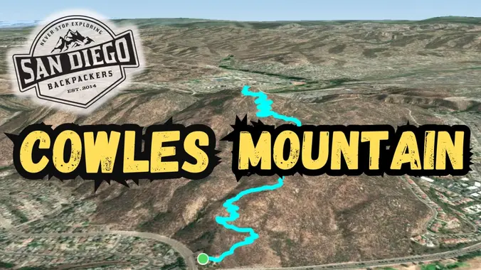
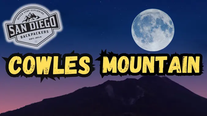
Full moon hike! Catch the Sturgeon Moonrise on top of Cowles! We'll meet in the parking lot around 7:00PM for a start of 7:15PM. The sun will set at 7:28PM, bring an adequate headlamp! The moon will rise at 7:50PM. Feel free to bring your dog, headphones, weights, your pack, or whatever makes your conditioning […]
We will hike Ray Miller Trail again starting at 7:30 am to beat the heat. The trail is an awesome blend of ocean and mountain views in Malibu’s La Jolla Canyon. We will start from the trailhead which follows the canyon eastward, away from the ocean. Then, it quickly brings you back toward the ocean […]
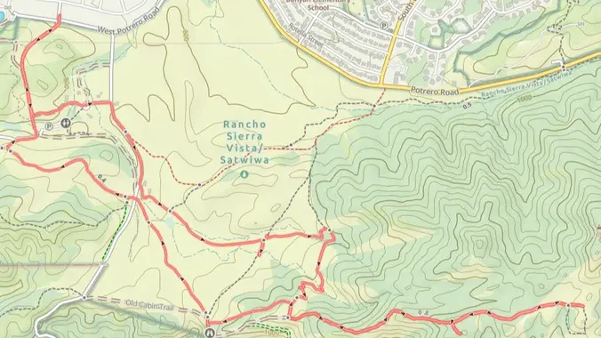
For this adventure, we'll hike a lollipop loop, starting at the Potrero Ridge trailhead off Mountain Creek Drive in Newbury Park, climb to the top of the ridge and follow it west to the heart of the Dos Vientos trail system. From there we'll make a clockwise loop along several trails, starting with Sierra Vista, […]
4.75 miles, 700' gain, easy-intermediate Option for 3 miles, 300' gain, easy. 30 minute wait while group completes the loop back to this spot. This is a link to the route: LINK We start with a 1/4 mile walk from where we park along Cottonwood Dr, to the trail head. There we make a left […]
http://photos1.meetupstatic.com/photos/event/9/9/3/6/event_278199222.jpeg Please read these restrictions before signing up. Don't show up unless you're shown on the "Attending" list Unregistered or waitlisted will be turned away No "Plus Ones" on this hike No dogs allowed Welcome Trailblazers! Time to return to a favorite trail once again! Let's bag a couple peaks in our beautiful Western Plateau. […]
Don't like being lost in the wilderness? Wanna stay found? Then join us for a FREE intro class to topographic map and compass navigation. Learn the anatomy of a compass and how it works. Understand topo maps and the wealth of info they contain. Practice orienting your map and taking a bearing. Sport Basement is […]
Group bonding event! Come hang out, see your friends, make new friends, and meet other backpackers! I've caught this SantanaWays show at Spreckles last year and it's AMAZING. Prepare to dance and have a blast! Wednesday, August 21st 6:00PM Balboa Park Spreckles Organ Pavillion FREE Summer Concert Meet at the Tea Pavillion (food station at […]
This gentler hike will be a little gentler than the second hike posted for Thursday, just sign up for one hike. We will start at 8:00 because of the heat. We will start at the parking area in Hill Canyon, cross the bridge over the runoff creek, and stroll a mile before turning onto the […]
Short and sweet hike! This week we’ll hike about 5 miles with 800' of total elevation gain, spread out nicely, with a little bonus loop through Oak Creek Canyon. "Robles" is Spanish for oaks, and we'll see plenty of them on this beautiful, relaxing hike. After a short street walk to get to the trailhead, […]
https://www.alltrails.com/trail/us/california/tapo-canyon-trail?u=i Hello Fellow Hikers, ( please read liability disclaimer at the bottom )  Join me on a easier moderate hike at Tapo Canyon Trail in Simi Valley. This hike has a nice gradual walk until we start a gradual climb were we will start our loop. We should encounter wildflowers and mountain views. Our […]
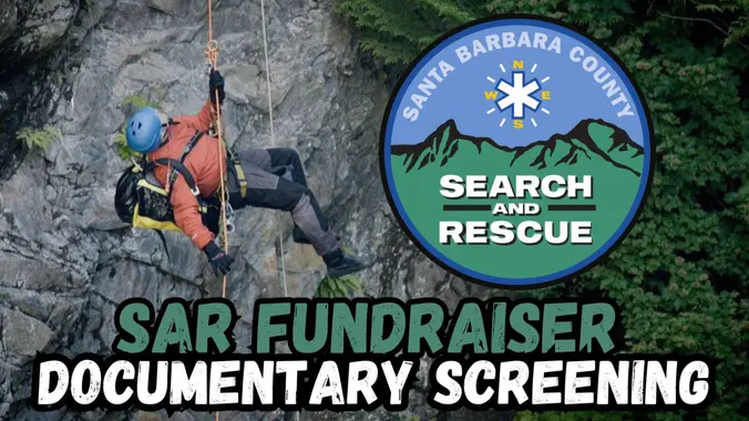
This is an announcement for our members near Santa Barbara who would like to support Santa Barbara Search and Rescue Foundation. This event is not hosted by San Diego Backpackers and there will be no "trip leader". Enjoy! Santa Barbara Search and Rescue Foundation Friday, August 23 6:30PM-9:00PM 721 Cliff Dr Santa Barbara, CA 93109 […]
This is one of my favorite hikes around! Come join us for a super fun adventure. Prepare to get wet! We cross the San Gabriel River multiple times. The hike is going to be going to the Bridge to Nowhere in Azusa, CA. This is located in the San Gabriel Mountains. This hike is an […]
DESCRIPTION: We start at sea level at the back of the La Jolla Canyon Group Camping Parking Area to head up the Ray Miller Backbone Trail. The trail winds back and forth across the hillside providing spectacular views of the Pacific Coast Highway and the Pacific Ocean. We climb almost 1000' in the first 2.7 […]
This relatively easy, out-and-back hike, travels alongside Malibu Creek through some great terrain and old growth oak trees, with a special bonus — a visit to the site of television's legendary program hit M*A*S*H*. The site still draws visitors from all over the world decades after the show left the air. Now on display are […]
I'll be camping and hiking at Sequoia Aug 25-29. Let me know if you'd like to join me on any of those days and I will put something together. I have a site reserved at Lodgepole Campground -- if you are unable to reserve a site anywhere let me know and I may have room […]
This hike will be about 5.4 miles total with 820 ft. of elevation gain. We are starting at the parking lot at the Wahoo's parking lot. We will take Live Oak Trail. This turns into Serrano Road which will take us to Serrano Cow Trail. At this part of the trail, we usually see a […]
4.2 miles, 700' gain, easy-intermediate. Easier option: 2.7 miles, 500' gain, fit beginner. This is a pot-luck hike. We'll be stopping at the 3/4 point by a picnic table, so please bring food and drink to share, and any utensils your items might require. You may wish to bring your own cup, plate, and utensils […]
The Tuesday weather forecast remains hot. We will hike Ray Miller Trail again as it is the coolest area to hike. The weather forecast on Tuesday at 8 am is 63 and at 11 am, 71. The trail is an awesome blend of ocean and mountain views in Malibu’s La Jolla Canyon. We will start […]
Please review the guidelines to participate in our hikes. Here are some highlights and a link to the guidelines. Restrictions apply for your safety and ours: Don't show up unless you're on the "Attending" list Unregistered or waitlisted will be turned away No "Plus Ones" on this hike Plan on completing the entire hike or […]
5.7 Miles, 1000' gain, Intermediate The starting point is NOT at the golf course entrance. It is at a dirt lot that can hold at least 50 cars. There is some real incline on this hike and a lot less trails coated with silt compared to the easier Happy Camp hike. Even though I have […]
Please note this hike will start at the trailhead we use for the Boney Hike (junction of South Wendy Drive and Portrero Road). We will take the single track trail about one-half mile to where the Angel Vista TH begins to add about an extra mile to the hike. Hoping to get back before it […]
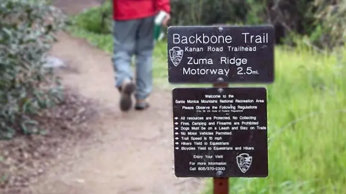
From the Kanan Rd trailhead, we'll jump on the Backbone Trail for a cruise down into Newton Canyon. On our way there, we'll cross the creek, pass under an oak canopy, and come out into an opening. At the opening, look toward the sandstone formations in the distance, and you'll see the now-maybe-flowing Upper Newton […]
This is also a gentler hike for Thursday starting at Newton Canyon, another group is starting at 8:30 and going down the backbone trail. We will go up and cross over Kanan and hike to Latigo. This hike was a bit overgrown last time but I am hoping they have come and trimmed it back, […]
3 miles, 650' gain, Fit Beginner Easy option, 1.4 miles, 450' gain, Fit Beginner The address given, is not the address of the hike. It is a nearby address that may cause your GPS to drive past the trailhead. Those that prefer the Easy Option, should head UP from the trail head, waiting when they […]
Start your holiday weekend off right with great friends and music! Come on out and join your friends, make new ones, eat, drink, and dance to an amazing 80's band at one of our favorite places for fun times. 80's Invasion, led by the dynamic vocal duo of Dirk Knight and Mony Mony, are a […]
MORE DETAILS AND PHOTOS WILL BE POSTED LATER. For moderately to advanced backpackers due to the longer mileage, several passes, and extreme steepness and unmaintained nature of Baxter Pass Trail. This hike requires us to shuttle vehicles between Onion Valley and Baxter trailheads. Add yourself to the waitlist and I will manually add you. Friday: […]
Join s for an invigorating sunrise yoga followed by a short and easy hike. A great start to your work day or weekend. More details will be posted soon.
The hike will be about 5.7 miles with about 750 ft. of elevation gain. We will start on Peters Canyon Trail and take this to East Ridge View Trail. This is where we will go up Big Red. Then we will continue on this trail until we get to Eucalyptus to loop back. We will […]
Eagle Rock, the most impressive landmark in all of Topanga State Park, will afford us an airy perch overlooking the upper watershed of Santa Ynez Canyon and the ocean beyond. We will eat, drink and explore on this impressive sandstone rock covered with crevices and caves. We'll get there the classic Musch Loop in a […]
The total mileage for this hike is 4.5 miles with about 460 ft. of elevation gain. We will start at the trail head of the Borrego Trail, which is right off of the parking lot. This is where we will meet. We will head up the Borrego Trail until we get to the Red Rock […]
5.2 miles, 1140' gain, Intermediate Eassier Option: 3.5 miles, 500' gain, Fit Beginner Come to the hike only (2:30p), picnic only (4:00p), or both. This event has limited space. Those still on the waiting list will be moved to the RSVP list several days before the event, or even the day of the event, if […]
Trail statistics are approximate. For safety purposes always assume they are underestimated. But don’t be disappointed if they are overestimated. Bring more water and snacks than you think you’ll need.
Trail descriptions are based on previous hikes. Current conditions are unknown until arrival. Expect the unexpected and plan accordingly.
The Organizers and members of Hiking With Dean are not professional leaders, guides, or mountaineers. The function of the member or organizer is only to organize the trip. Each person who shows up for a trip/meetup (and their guest or guests) is responsible for his or her own safety. By attending a hike, or any other event organized by this group, you are acknowledging that you and any guests that you bring are aware of the risks, dangers and hazards associated with the activity and freely accept and fully assume all such risks, dangers and hazards, and further agree to release and discharge the Organizers, Members of the Hiking With Dean Meetup Group from and against any and all liability arising from your participation in the group activities per our ASSUMPTION OF RISK AND LIABILITY WAIVER and Section 6.2 of the Meetup.com Terms of Service.


Recent Comments