

————————————————- THE QUEST —————————————–
My pursuit of taking on Mount Baden Powell the hard way, via The Big Horn Mine on my 75th birthday, has finally arrived.
Join me and experience the thrill of cross country hiking in the high country of the San Gabriel Mountains as we take on Mount Baden Powell via it’s eastern ridgeline.
This all day trek is for those of you who are looking for something a lot more challenging than the average outing. No beginners please unless you’re in good physical condition. If you have some place to be later in the day, this event will not work for you.
We will be setting a steady pace with several breaks while staying together all the way so as not to lose anyone. This event will be accomplished via a car shuttle.
POLES AND MICRO SPIKES ARE RECOMMENDED
———————————————– DAY’S AGENDA —————————————
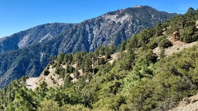
START: We’ll start the hike by taking an old dirt road leading from Vincent Gap to the BIG HORN MINE.
BIG HORN MINE: Named after the majestic Bighorn Sheep that still roam this area, it is by far the largest abandoned mine in the San Gabriel Mountain range, with a long and colorful history to match. Located deep beneath Mt. Baden Powell, it has been estimated that all tunnels combined measure well over two miles in length. I will save the exploration of this mine for our next adventure there. Instead, we will take on the Baden Powell Mine Ridgeline.
BADEN POWELL MINE RIDGELINE: The route to the top of Mt. Baden Powell along its eastern backbone is the most challenging and by far most avoided, in fact, it’s not even listed in The Sierra Club’s routes to the top. This no nonsense kick in the @$$ cross country route will require a person with legs of steel and fearless of heights. This steep backbone at times resembles a knives edge with steep drop offs into the huge bowl of Mine Gulch, and it makes the backbones of Mt. Baldy look meek in comparison. As we near the top of this ridgeline, we’ll run into the PCT trail which takes us up to MOUNT BADEN POWELL.
MOUNT BADEN POWELL: Standing at 9407′, this peak is named for the founder of the World Scouting Movement, Robert Baden-Powell, 1st Baron Baden-Powell. It was officially recognized by the USGS at a dedication ceremony in 1931. It was originally known as East Twin or North Baldy. After taking on Baden Powell, we’ll then follow the PCT trail westward towards Mount Burnham until we reach a steep trail less ridgeline which we’ll follow down to our cars.
—————————————- MEETUP LOCATIONS ————————————–
MEETUP LOCATION AND TIME: Glendale (Harvey) Park and Ride at 6:30 am
IF MEETING THE GROUP THERE, YOU MUST STATE SO, OTHERWISE I WON’T BE STOPPING THERE.
EARLIER MEETUP LOCATION AND TIME: Woodland Hills Meetup location at 5:45am.
IF MEETING THERE, LET ME KNOW, OTHERWISE I WON’T BE STOPPING THERE.
FINAL MEETUP LOCATION AND TIME: Vincent Gap along Hwy. 2 at 7:30am. We’ll all meet here.
———————————————– STATS ————————————————–
DURATION: We’ll want to finish the hike and be back to the cars by 3:00 p.m. at the latest, followed by lunch in Wrightwood at the Mexico Lindo & Seafood Restaurant.
TERRAIN: Old dirt road, steep use trails on ridgelines and a bit of the PCT
DISTANCE: 5+ miles
ELEVATION RANGE: Gain of 3000′ and a loss of 2800′
THE PACE: A comfortable pace no faster than the slowest hiker.
LEVEL: Strong Intermediate hiker
MY CELL NUMBER IS: 805-538-5972
DOGS ALLOWED: NO


