

[av_notification title=’Trail Update’ icon_select=’no’ icon=’ue83f’ font=’entypo-fontello’ color=’orange’ border=’solid’ custom_bg=’#444444′ custom_font=’#ffffff’ size=’large’ close_btn=” cookie_lifetime=’60’ av_uid=’av-sqyudk’ custom_class=” admin_preview_bg=”]
I have been informed that there is a new (passable) fence and no trespassing sign in Chivo Canyon. The sign points in the same direction we are hiking so we will be exiting the area at this point. The sign is a little over half-way into the hike. I don’t know if there will be any other signs along the way that will prevent us from entering the other end of that area. I do have a Plan B if a sign prevents us from moving forward, but it may create a longer hike. Expect the Unexpected!
[/av_notification]
Here is a map of planned route with explanations
[av_one_full first min_height=” vertical_alignment=” space=” custom_margin=” margin=’0px’ row_boxshadow=” row_boxshadow_color=” row_boxshadow_width=’10’ link=” linktarget=” link_hover=” title_attr=” alt_attr=” padding=’0px’ highlight=” highlight_size=” border=” border_color=” radius=’0px’ column_boxshadow=” column_boxshadow_color=” column_boxshadow_width=’10’ background=’bg_color’ background_color=” background_gradient_color1=” background_gradient_color2=” background_gradient_direction=’vertical’ src=” background_position=’top left’ background_repeat=’no-repeat’ animation=” mobile_breaking=” mobile_display=” av_uid=’av-1hmes7c’]
[av_textblock size=” font_color=” color=” av-medium-font-size=” av-small-font-size=” av-mini-font-size=” av_uid=’av-jx6ubjpg’ custom_class=” admin_preview_bg=”]
Join our Facebook group – https://www.facebook.com/groups/hikingwithdean/
Learn why this is one of the best Simi hikes! We will be hiking a counter-clockwise loop on eroded ranch roads and little-used goat and cow trails through oak woodlands and along a creek. On the way we will come across grazing cattle, marine fossils and the old Coquina Mine. At the abandoned limestone mining operation, atop a peak, you can sit in the operator’s seat of a large steam shovel. On a clear day you can see the ocean from atop the ridgeline.
[/av_textblock]
[/av_one_full][av_one_half first min_height=” vertical_alignment=” space=” custom_margin=” margin=’0px’ row_boxshadow=” row_boxshadow_color=” row_boxshadow_width=’10’ link=” linktarget=” link_hover=” title_attr=” alt_attr=” padding=’0px’ highlight=” highlight_size=” border=” border_color=” radius=’0px’ column_boxshadow=” column_boxshadow_color=” column_boxshadow_width=’10’ background=’bg_color’ background_color=” background_gradient_color1=” background_gradient_color2=” background_gradient_direction=’vertical’ src=” background_position=’top left’ background_repeat=’no-repeat’ animation=” mobile_breaking=” mobile_display=” av_uid=’av-1cclsjs’]
[av_textblock size=” font_color=” color=” av-medium-font-size=” av-small-font-size=” av-mini-font-size=” av_uid=’av-jx6udjnb’ custom_class=” admin_preview_bg=”]
While you are there, don’t forget to get a picture of yourself on the steam shovel This is a P&H Model 206 steam shovel from 1920s. There is lots more mining equipment strewn about. My research indicates that the equipment was abandoned at the Coquina mine after a fire.

[/av_textblock]
[/av_one_half]
[av_one_half min_height=” vertical_alignment=” space=” custom_margin=” margin=’0px’ row_boxshadow=” row_boxshadow_color=” row_boxshadow_width=’10’ link=” linktarget=” link_hover=” title_attr=” alt_attr=” padding=’0px’ highlight=” highlight_size=” border=” border_color=” radius=’0px’ column_boxshadow=” column_boxshadow_color=” column_boxshadow_width=’10’ background=’bg_color’ background_color=” background_gradient_color1=” background_gradient_color2=” background_gradient_direction=’vertical’ src=” background_position=’top left’ background_repeat=’no-repeat’ animation=” mobile_breaking=” mobile_display=” av_uid=’av-kzwz54′]
[av_textblock size=” font_color=” color=” av-medium-font-size=” av-small-font-size=” av-mini-font-size=” av_uid=’av-jx6uf99j’ custom_class=” admin_preview_bg=”]
Fiddleneck and Lupine abound!

[/av_textblock]
[/av_one_half]
[av_textblock size=” font_color=” color=” av-medium-font-size=” av-small-font-size=” av-mini-font-size=” av_uid=’av-jx6ubc55′ custom_class=” admin_preview_bg=”]
Follow that cow!

We’ll be doing a little creeking too
[asa2_collection tpl=”Flat_box_horizontal” orderby=”rand” show_features=”no” show_description=”no” limit=”1″]6[/asa2_collection]

Watch for fossils along the way

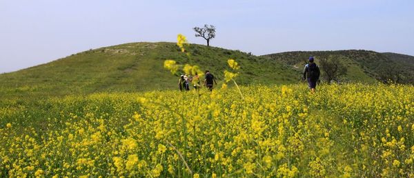
Here we are heading down one of the cow trails

Hike is about 9.2 miles with 1000 ft net elevation gain/2000 ft total ascent. Wear long pants
Post-hike lunch
The Junkyard Cafe
2585 Cochran St
Park in rear
Click on year for More Photos:
Directions to trailhead:
Take the 118 and exit Yosemite Ave. Head north on Yosemite for 1.3 mile to where the road splits and hang a right on Evening Sky Dr. Go 0.5 mile to the Las Llajas trailhead on the left

[/av_textblock]


