• Danielson Monument – potluck hike (start 3:00PM)

    4128 Potrero Rd 4128 Potrero Rd, Thousand Oaks, CA, US

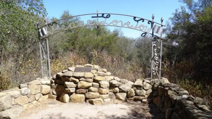
    6.5 miles, 1300' gain, intermediate This is harder and longer than our usual hikes. Please read the definition carefully. Let's enjoy hiking to the Danielson Monument in the Boney Mountain Wilderness, potluck, and "Peace, Love and Joy"! Please bring food and drinks to share. We'll have our typical snack-share social event at the top for […]

  • Chesebro Canyon MTB trail potluck hike – fit beginner

    5402 Chesebro Rd 5402 Chesebro Rd, Agoura Hills, CA, US

    Fit Beginner 4.3 miles, 480' gain. Easier Option: 4 miles, 230' gain. We walk a mostly flat section for 1.1 mi. to the 2nd junction. Easier option: Continue straight for 3/4 mi., left at the split, right after another 500', arriving at some picnic tables on the right after another 750'. Regular route: Left, heading […]

  • Gentler / Beginner: Kanan Dume to Latigo – 5 miles

    Newton Canyon Trailhead 1600 South Kanan Dume Road, Malibu, CA, US

    This is an easier hike for Tuesday, another has also been posted close by, please only sign up for one hike. This hike is only 5 miles and will take us on a less-traveled but quite beautiful part of the 67-mile Backbone Trail, which runs through the Santa Monica Mountains National Recreation Area from Will […]

  • Hike Bommer Ridge into Laguna Coast Wilderness – Loop

    Crystal Cove SP/Laguna Coast - Ridge Park Entrance (map) Ridge Park Rd & E Coastal Peak, Newport Beach, CA, US

    The total distance for this hike is 4.5 miles with about 650 ft. of elevation gain. There are great mountain and ocean views along the ridge. We are going to start on Bommer Ridge Trail and take this to Lizard Trail. We will go down that and loop back up to Bommer via Upper Laurel. […]

  • Ray Miller Trail in La Jolla Canyon ~ Gentler Intermediate

    Ray Miller Trailhead Malibu, CA, US

    Let's try Ray Miller Trail after last week’s rain. The trail is an awesome blend of ocean and mountain views in Malibu’s La Jolla Canyon. We will start from the trailhead which follows the canyon eastward, away from the ocean. Then, it quickly brings you back toward the ocean at a gradual incline. There’s a […]

  • Fall In To the Gap – Latigo to Corral Canyon ~ Intermediate Hike

    Latigo Canyon Trailhead 1765 Latigo Canyon Rd, Malibu, CA, US

    Today we'll hike the Backbone Trail looking for wildflowers. We'll begin at Latigo Canyon and walk on dirt and stuff until we reach the familiar sandstone structures of Mesa Peak Motorway. Along the way, we'll cross Castro Crest and descend into Upper Solstice Canyon before we climb to Mesa Peak Motorway, at the top of […]

  • Limekiln Canyon Lollipop – Suitable for beginners

    Limekiln Canyon Trail 19569 Rinaldi Street, Porter Ranch, CA, US

    4 mi, 500' gain, beginner Easier option: 1.5 mi, 125' gain, beginner. This is a beginner hike on the beautiful Limekiln trail. This hike is a slight lollipop, (the shape of the route). There are no extended inclines, however there are about 5 bumps in the trail with 25-40' gains, about 35-65 steps each. This […]

  • Rosewood Trail: Lynn to Angel Vista – Gentler Intermediate

    150 Regal Oak Ct 150 Regal Oak Ct, Thousand Oaks, CA, US

    Meet at the Rosewood sign, which is at the Regal Oak Ct. and Lynn Rd. intersection. The hike is about 5 miles with an elevation gain/loss approximately 900’. We'll walk a short distance on Lynn road to the lower Rosewood Trail, then take the dirt trail up a shaded ravine and continue on the Rosewood […]

  • Lindero Canyon Road to Simi Peak (Fast Paced)

    Lindero Canyon & Wembly Lindero Canyon Road & Wembly Ave, Oak Park, CA, US

    http://photos1.meetupstatic.com/photos/event/e/3/a/0/event_167038272.jpeg This hike has some rocky parts, but no scrambling. This hike will take us on a scenic trip from the suburbs of Oak Park to the top of Simi Peak, which overlooks both the Simi and Conejo Valleys and offers splendid views of the Santa Monica range and offshore islands to the south and […]


Trail statistics are approximate. For safety purposes always assume they are underestimated. But don’t be disappointed if they are overestimated. Bring more water and snacks than you think you’ll need.

Trail descriptions are based on previous hikes. Current conditions are unknown until arrival. Expect the unexpected and plan accordingly.

The Organizers and members of Hiking With Dean are not professional leaders, guides, or mountaineers. The function of the member or organizer is only to organize the trip. Each person who shows up for a trip/meetup (and their guest or guests) is responsible for his or her own safety. By attending a hike, or any other event organized by this group, you are acknowledging that you and any guests that you bring are aware of the risks, dangers and hazards associated with the activity and freely accept and fully assume all such risks, dangers and hazards, and further agree to release and discharge the Organizers, Members of the Hiking With Dean Meetup Group from and against any and all liability arising from your participation in the group activities per our ASSUMPTION OF RISK AND LIABILITY WAIVER and Section 6.2 of the Meetup.com Terms of Service.