

Distance: 9.5 Miles
Elevation Gain: 2800 ft.
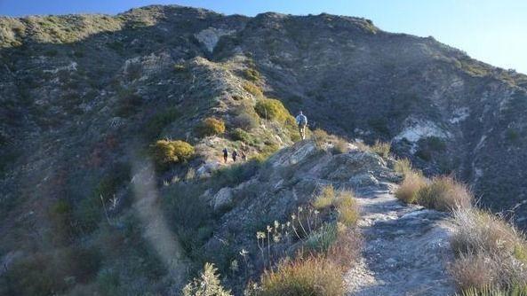
Trail: Single track, fire road, uneven downhills.
Rating: 8/10, due to trail condition
Pace: Intermediate to advanced
Not for beginners-there won’t be a sweeper!!
The Plan Story
Not many small- or medium-sized cities can boast three mountain ranges within its border, but Glendale does. Stretching east and north from the San Fernando Valley, the city takes in substantial parts of the San Rafael Hills and the Verdugo Mountains, plus a small slice of the San Gabriel Mountains at the city’s northern extremity.
At this northernmost spot in Glendale, overlooking the foothill communities of La Crescenta and Tujunga, lies Deukmejian Wilderness Park, named after the former California Governor George Deukmejian. The park’s 700 acres of chaparral-covered slopes are drained by two ravines with steep gradients: Cooks Canyon and Dunsmore Canyon. During the mid-20th Century, the area alongside the Dunsmore Canyon stream was used by the Le Mesnager family as a vineyard, An old stone barn at the trailhead is reminiscent of that time.
Mt. Lukens is the tallest peak within the Los Angeles city limits, and it has spectacular views of the Los Angeles basin and surrounding mountains from the summit.
This trip makes a loop from Deukmejian Wilderness Park in Glendale, ascending via the Crescenta View Trail to the Haines Canyon Motorway to Mount Lukens. Our return route will continue on the Haines Canyon Motorway to the Rim of the Valley Trail, returning to Deukmejian Wilderness Park via Cook’s Canyon a nicely shaded area with a small creek. The views on both legs of the hike are great. If visibility is good, expect to see Catalina Island, Santa Barbara Island, the entire Santa Monica range, and more.
The downhill portion of the Rim of the Valley trail in particular has some areas of loose rocks and soil as well as a few Yucca maize portions. Walking sticks could be helpful to some in these areas.

Dogs: Welcome on this one as long as they have good trail manners and are picked up after.
Directions: From the 210 Freeway exit Pennsylvania Ave (17A) and go north to Foothill Blvd. Turn left on Foothill Blvd. and go to New York Ave. Turn right on New York Ave. and go to the end, Markridge Rd. Turn left on Markridge and go about 200 yards to the park entrance on your right. Follow the entry road up to the parking area. Parking is free and there are restrooms and a water fountain near the trail head.
No Carpooling recommended for the time being
**********************************************
PLEASE – Know your limits and abilities. Bring snacks and drink plenty of liquids when hiking. Check weather conditions and dress accordingly and be aware of your surroundings at all times. Watching out for poison oak, snakes, ticks, uneven footing, spectacular views, beautiful fauna all while interacting with awesome (usually) fellow hikers can be extremely hazardous, rewarding and fun.
VHC HIKE RATING SCALE
Rating a hike is subjective, meaning the difficulty of a hike will be in direct relation to how often you hike and the type of hike you prefer. Keep in mind that any hike can have the following: un-even hiking surfaces, various obstructions, water and/or water crossings or bouldering and/or rock hopping. A great hike will have all of these!
1 – A long walk
2 – 4 mile hike w/little elevation gain
3 – 5 mile hike w/up to1000 ft. elevation gain
4 – 5+ mile hike w/up to1500 ft. elevation gain (heart rate increases at times)
5 – 7+ mile hike w/over 1500 ft. elevation gain (heart rate increasing even more at times)
6 – 7+ mile hike w/over 2000 ft. elevation gain (at times you might be trying to remember how to perform CPR)
7 – 5+ mile hike w/over 2000 ft. elevation gain (at times you might be muttering expletives to yourself)
8 – 10+ mile hike w/over 3500 ft. elevation gain (at times you might be angry with the hike leader)
9 – 10+ mile hike w/over 5000 ft. elevation gain (at times you might be thinking of reporting the hike leader to the authorities)
10 – Use your imagination
Class 3 Scrambling: Scrambling or un-roped climbing. You must use your hands at times to hold the terrain or find your route. This may be caused by a combination of boulders, steepness and extreme terrain. Some Class 3 routes have ropes in place for assistance.
DISCLAIMER / RELEASE OF LIABILITY
IMPORTANT, PLEASE READ BELOW IN ITS ENTIRETY:
I am a volunteer (i.e. not liable for the group). Safety is a priority for everyone in the group. Think of this as hiking with a group of friends.
Outdoor sports and other events we plan can be inherently dangerous and accidents may happen. By participating in any posted event, you’re taking responsibility for your own safety and well-being. The Valencia Hiking Crew Meetup Group and its organizers are not trained leaders and we do not confirm the qualifications of any of its members to lead or participate in trips. All participants take full responsibility for their own actions. If you choose to sign up for any Valencia Hiking Crew Meetup events, you are releasing the Valencia Hiking Crew Meetup Group and it’s organizers from all liability in case of possible injuries as stated in paragraph 6.2 of the Meetup “Terms of Service” located on the bottom of the Meetup website. Your personal safety depends on your own judgment and experience.


