

Want to walk off some of that Thanksgiving feast and not deal with the shopping mall crowds? Then let’s do our annual after Thanksgiving Day Don’s Rocky IV Not the Movie. This is about a five hour hike, so we should be back to our cars by 2:00pm or thereabouts.

Distance: 9 miles Dual Rating: Baldy Lovers: 3/10 Baldy Haters: 6/10
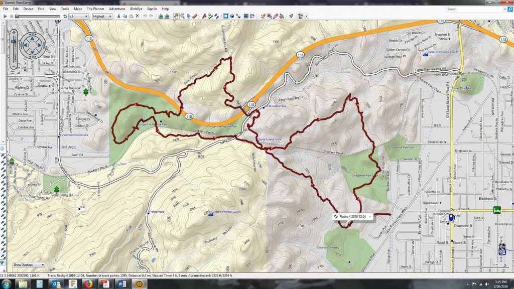
Elevation gain: 1400 feet The Trail: A figure 8 loop through 4 rocky parks.
The Plan: I’ve improved a previous route as we’ll be taking the Old Stagecoach Road to Rocky Peak to Corriganville Park via the Wildlife Corridor to Chatsworth Park to our cars.
Bring lunch as there are ample picnic tables in Corriganville.
The Old Santa Susana Stagecoach Road is a route taken by early travelers between the San Fernando Valley and Simi Valley near Chatsworth, California via the Santa Susana Pass. The main route climbs through what is now Santa Susana Pass State Historic Park, with a branch in Chatsworth Park South. It was an important artery linking the Los Angeles Basin and inland Ventura county, and was part of the main route for travel by stagecoach between Los Angeles and San Francisco from 1861 until the opening of rail traffic between the cities in 1876. The Old Santa Susana Stage Road is listed on the National Register of Historic Places.
Dogs are welcome, if friendly and must be leashed, washed, fed and picked up after. Be on the lookout for rattlesnakes, ticks, zombies, great views, awesome sights, friendly fellow hikers and martians.
[url=http://www.weather.com/outlook/driving/interstate/local/91311?lswe=91311&from=searchbox_localwx]Check the Weather[/url] [url=http://www.mapquest.com/maps?city=Chatsworth&state=CA&address=10226+Larwin+Ave&zipcode=91311-7432&country=US&latitude=34.256494&longitude=-118.614808&geocode=ADDRESS]Mapquest[…]
Directions: Go west on Devonshire from Topanga Canyon as if you are going to Chatsworth Park. Instead of driving into the (closed) park entrance, turn left (south) on Larwin Street and go one block until you come to a chain link fence on your right. This is very easy to locate because in addition to the fence, an old set of power lines runs directly overhead. Park along the curb. We will enter the park through a gap in the fence.
1 – A walk
2 – A longer walk
3 – 3 mile hike w/little elevation gain
4 – 5+ mile hike w/500 ft. elevation gain (heart rate increases at times)
5 – 5+ mile hike w/1000 ft. elevation gain (heart rate increasing even more at times)
6 – 7+ mile hike w/1000 ft. elevation gain
7 – 7+ mile hike w/1500 ft. elevation gain (at times you might be trying to remember how to do CPR)
8 – 5+ mile hike w/2000 ft. elevation gain (a great feeling of accomplishment when done)
9 – use your imagination
10 – I don’t lead or do these.
DISCLAIMER / RELEASE OF LIABILITY IMPORTANT, PLEASE READ BELOW IN ITS ENTIRETY: I am a volunteer (i.e. not liable for the group). Safety is a priority for everyone in the group. Think of this as hiking with a group of friends. Outdoor sports and other events we plan can be inherently dangerous and accidents may happen. By participating in any posted event, you’re taking responsibility for your own safety and well-being. The Valencia Hiking Crew Meetup Group and it’s organizers are not trained leaders and we do not confirm the qualifications of any of its members to lead or participate in trips. All participants take full responsibility for their own actions. If you choose to sign up for any Valencia Hikers Meetup events, you are releasing the Valencia Hiking Crew Meetup Group and it’s organizers from all liability in case of possible injuries. Your personal safety depends on your own judgment and experience. CONTACT ME WITH ANY QUESTIONS!


