

Advanced Intermediate Hikers. You should be able: (1) to comfortably hike from an elevation of 8,100 ft. and summit at 10,000 ft., and (2) handle heights.
Plan: To sleep in the car the day before the hike. The trailhead is inside the Yosemite NP. Toll is required to enter the park.
Distance: About 15 miles round trip
Trailhead Elevation: 8,150 feet (2,450 meters)
Clouds Rest Elevation: 9,926 feet (3,025 meters)
Elevation Gain: 1,775 feet (540 meters)
Difficulty: Strenuous, but not in the Half Dome category (speaking of strenuous, bring binoculars and you can watch hikers making their way up the Half Dome cables from here). An 8 out of 10. The most difficult part, unless you’re afraid of heights, will be a thousand-foot-gaining series of switchbacks about a mile and a half into the hike.
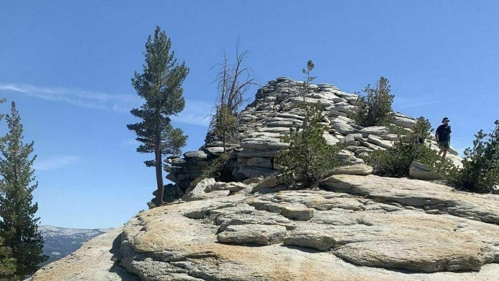
Scenery Summary: This hike is all about the destination, from which you’ll have striking views in every direction, including, perhaps most gripping of all, straight down. Turn a complete circle and you’ll be able to see any number of Yosemite landmarks, including Tenaya Lake, Half Dome, Mt. Hoffman, Sentinel Dome, North Dome, and bits of Cathedral Rocks and El Capitan, plus Merced Lake and dozens of peaks you probably won’t be able to name.
Parking: A lot at the trailhead holds a dozen or so cars. It will be full. Look for spots along the shoulders of the road; you shouldn’t have to wander too far to find an opening. One temptingly empty area just across the road from the parking lot is signed as a no-parking zone just to see if you’re paying attention.
Nearest Bathrooms: Pit toilet at the trailhead. You can find bathrooms with plumbing at the Tuolumne Meadows Visitor Center, 5 miles (8 km) east.
Acrophobics Beware: The top of Clouds Rest is a narrow ridge with a long, sheer dropoff on the north side (the side you can see from the Tioga Road). The dropoff to the south is less extreme, but it wouldn’t require special talent to wind up just as thoroughly and symmetrically dead by falling off that side. It’s best to visit Clouds Rest sober and during dry weather.
That said, the route over the ridge is more manageable and less dangerous than Half Dome’s cable route. If you’re slow and careful, you shouldn’t feel like you’re a freak gust of wind or a momentary lapse of concentration away from the bottom of Tenaya Canyon. And the very top of the peak opens up again to around fifty feet wide, which will feel like the Great Plains after the underpants-imperiling knife edge you’ve just crossed to get there.
*******************************************************************
DISCLAIMER / RELEASE OF LIABILITY
I am a volunteer (i.e. not liable for the group). Safety is a priority for everyone in the group. Think of this as hiking with a group of friends.
Outdoor sports and other events we plan can be inherently dangerous and accidents may happen. By participating in any posted event, you’re taking responsibility for your own safety and well-being. The Valencia Hiking Crew Meetup Group and its organizers are not trained leaders and we do not confirm the qualifications of any of its members to lead or participate in trips. All participants take full responsibility for their own actions. If you choose to sign up for any Valencia Hiking Crew Meetup events, you are releasing the Valencia Hiking Crew Meetup Group and it’s organizers from all liability in case of possible injuries as stated in paragraph 6.2 of the Meetup “Terms of Service” located on the bottom of the Meetup website. Your personal safety depends on your own judgment and experience.


