

4 miles, 1100′ gain, Intermediate.
Fit beginners can still do it, but they should be aware that the entire hike outbound is a steady incline. Nothing super steep, just continuous and quite strenuous for many.
That’s OK, because this is not a conditioning hike, it’s a social hike. We’ll be stopping at various points to let people catch up, and there are virtually no junctions where one can get lost.
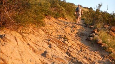
This is one of the more famous hikes in Simi Valley, and for good reason. Much of the hike takes place along the edge of the mountain. The trail in spots is a bit rugged and rocky, so a good tread on your shoes is recommended.
It is a part of the Chumash Natural Park that includes sandstone rock formations, caves, and beautiful vistas of Simi Valley. The land is owned by the Santa Monica Mountains Conservancy and the Rancho Simi Recreation & Park District. It is maintained by the Rancho Simi Trailblazers and patrolled by the Volunteer Trail Safety Service.
We’ll be climbing for about 2 miles to “flat rock”, where we’ll stop to have our traditional social event, sharing snacks and beverages (https://www.meetup.com/Hiking-Plus/messages/boards/thread/50879772). Since there is really no way to get lost on this hike, those that wish to move ahead at a faster pace are welcome to do so, but keep in mind where we plan on stopping, and then ultimately turning back.
The Route.
Hike.
Distance: 4.0 miles
Gain: 1100′
Distribution: Most of the incline is concentrated in the first half.
Difficulty (https://www.meetup.com/Hiking-Plus/messages/boards/thread/50879781): Intermediate.
Shape: Out and back.
Pace: approx. 2.0 mph.
Trail Type: Fire road, double track, single track.
Trail Variations: The entire first half is incline. Some of the trail is rugged sandstone. Some of the trail is covered in large gravel. Proceed carefully.
Duration: 3.5 hours
Dogs: Yes.
Restrooms: No
Drinking Fountains: No.
Parking: Free along street.
What to bring: 1 liter of water for every 3 miles.
Hiking shoes/boots. Not required, but recommended.
Flashlight or headlamp.
Sunscreen and/or hat as needed.
Snacks and/or beverages to share (https://www.meetup.com/Hiking-Plus/messages/boards/thread/50879772).
Hosting
Route: The host knows the route. A pic of the route has been posted as part of this description.
Navigation: Host memory, enhanced by GPS navigation as needed.
Hike type: Social.
We won’t be hiking at a fast pace because this is a social hike, not a conditioning hike. There is nothing wrong with stopping, even if it means every 50 steps. See “How hard is this hike” in the discussion section (LINK (https://www.meetup.com/Hiking-Plus/messages/boards/thread/50879781)).
Stops: The host may designate stopping points to let others catch up. This hike will include an extended stop for a snack and beverage (https://www.meetup.com/Hiking-Plus/messages/boards/thread/50879772) share at the half way point. There may not always be a sweeper designated to be the last hiker.
Each hiker is responsible for knowing their capability, only attending events where they are able to sustain the described pace, for keeping up with the group sufficiently enough to make the turns and not get left behind, and for making sure the host is notified if they are going to split from the group.
Group separation: Sometimes hikers wish to move significantly ahead and not wait at designated stopping points. Please let the host know. They are on their own regarding route and navigation.
Interesting Notes
Here are a couple plants you are sure to see on this hike:
California Encelia
Aka, California Bush Sunflower, California Brittlebush, Coast Sunflower, El Dorado.
Center is brown. When the center is yellow, it is Brittlebush, from the brittleness of the stems. This is from the daisy family, and it is typically used as an ornamental plant.
Mediterranean Mustard / Black Mustard
Mediterranean mustard seeds are yellow or white, while Black mustard seeds are brown or black. The flowers look the same.
Flowers, leaves (mustard greens), and roots are edible. Can be used as a spice. Grind seeds and mix with water and vinegar to make prepared mustard. This is often a very abundant noxious weed (has been designated by an agricultural authority as one that is injurious to agricultural or horticultural crops, natural habitats or ecosystems, or humans or livestock.). It grows everywhere along the sides of the trail, often having to be cut back during trail maintenance.
Directions:
Chumash Trail
3200 Flanagan Dr.
Simi Valley, CA 93063
Coordinates of trailhead: 34.293497, -118.671176
From CA-118:
I-118, exit Yosemite.
North on Yosemite for 1.3 miles.
Right (east) on Flanagan Dr. for 08. miles.
Continue until the street ends and park.
Release of Liability: https://www.meetup.com/Hiking-Plus/pages/29622459/Is_Hiking_Dangerous/


