Hiking Calendar
- No hikes scheduled for April 7, 2025.
- No hikes scheduled for April 9, 2025.
INFORMATIONAL POSTING -36th Annual Beginning Backpack Class
La Crescenta-Montrose La Crescenta-MontroseLimekiln Canyon Lollipop – Suitable for beginners
Limekiln Canyon Trail 19569 Rinaldi Street, Porter RanchINFORMATIONAL POSTING -36th Annual Beginning Backpack Class
La Crescenta-Montrose La Crescenta-MontroseINFORMATIONAL POSTING -36th Annual Beginning Backpack Class
La Crescenta-Montrose La Crescenta-Montrose- No hikes scheduled for April 11, 2025.
Get off the beaten path with the local Lyons Ranch and Taylor Loop Trail
Humber Park Fern Valley Road 24559, Idyllwild-Pine CoveHike to Sitton Peak – Bear Canyon & Verdugo Truck Trail – Santa Ana Mountains
San Juan Loop Trailhead 34040 Ortega Hwy., Lake ElsinoreHike at Whiting Ranch – Cactus Hill & Billy Goat
Wahoo's Fish Taco 27412 Portola Parkway, Foothill RanchHike at Aliso and Wood Canyons Park – Up Cholla, Down Mathis
Canyon View Staging Area 22124 Utility Access, Aliso ViejoWeek of Hikes
Nicholas Flat from Leo Carillo State Park – Intermediate to Strenuous
Nicholas Flat from Leo Carillo State Park – Intermediate to Strenuous
Time to go to the beach! And up a long hill, around the pond, and back down the hill. We may even stop at your grandmother's house. Our route will take us from the outer parking lot at Leo Carrillo State Park (just off PCH at Mulholland) all the way up to Nicholas Pond. We'll […]
Ray Miller Trail in La Jolla Canyon ~ Gentler Intermediate
Ray Miller Trail in La Jolla Canyon ~ Gentler Intermediate
The trail is an awesome blend of ocean and mountain views in Malibu’s La Jolla Canyon. We will start from the trailhead which follows the canyon eastward, away from the ocean. Then, it quickly brings you back toward the ocean at a gradual incline. There’s a great lookout spot where it gives you a breathtaking […]
Chumash – Intermediate, with Easy option
Chumash – Intermediate, with Easy option
4 miles, 950' gain, Intermediate Easy Option: 1.6 miles, 400' gain, Fit Beginner Hardest option: 5 miles, 1200' gain, Intermediate The entire hike outbound is a steady incline. Nothing super steep, just continuous and quite strenuous for many. There are virtually no junctions where one can get lost. This is one of the more famous […]
INFORMATIONAL POSTING -36th Annual Beginning Backpack Class
INFORMATIONAL POSTING -36th Annual Beginning Backpack Class
INFORMATIONAL POSTING ONLY Have you ever wanted to learn to backpack and get away from the crowds of people? Learn how to backpack in 3 Saturday courses (4/26, 5/10, 5/17) culminating in a backpack trip on 5/31-6/1 to utilize the techniques you learned. Course times are 10:30 AM-2:30 PM Learn what to take, latest in […]
Los Robles WEST/Moorpark Trail
Los Robles WEST/Moorpark Trail
This is a second hike for Thursday. If you decide to switch hikes, be sure to cancel Laurie's hike even if you're on the waitlist. Some people are having trouble finding the EDIT button to cancel. If you encounter that problem, just cancel in the COMMENTS. This hike is in the same area as last […]
Lynn Road to Rosewood Trail to Angel Vista ~ gentler friendly
Lynn Road to Rosewood Trail to Angel Vista ~ gentler friendly
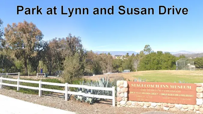
This is a 4-5 mile out-and-back trip from Lynn Road to the Rosewood Trail to Angel Vista. We’ll park at the playfield near Stagecoach Inn and walk from Lynn Road on the lower Rosewood Trail, to the usual trailhead and then on up the trail. The elevation gain/loss is about 875’ - 1000’. It is […]
Limekiln Canyon Lollipop – Suitable for beginners
Limekiln Canyon Lollipop – Suitable for beginners
4 mi, 500' gain, beginner Easier option: 1.5 mi, 125' gain, beginner. This is a beginner hike on the beautiful Limekiln trail. This hike is a slight lollipop, (the shape of the route). There are no extended inclines, however there are about 5 bumps in the trail with 25-40' gains, about 35-65 steps each. This […]
INFORMATIONAL POSTING -36th Annual Beginning Backpack Class
INFORMATIONAL POSTING -36th Annual Beginning Backpack Class
INFORMATIONAL POSTING ONLY Have you ever wanted to learn to backpack and get away from the crowds of people? Learn how to backpack in 3 Saturday courses (4/26, 5/10, 5/17) culminating in a backpack trip on 5/31-6/1 to utilize the techniques you learned. Course times are 10:30 AM-2:30 PM Learn what to take, latest in […]
INFORMATIONAL POSTING -36th Annual Beginning Backpack Class
INFORMATIONAL POSTING -36th Annual Beginning Backpack Class
INFORMATIONAL POSTING ONLY Have you ever wanted to learn to backpack and get away from the crowds of people? Learn how to backpack in 3 Saturday courses (4/26, 5/10, 5/17) culminating in a backpack trip on 5/31-6/1 to utilize the techniques you learned. Course times are 10:30 AM-2:30 PM Learn what to take, latest in […]
Get off the beaten path with the local Lyons Ranch and Taylor Loop Trail
Get off the beaten path with the local Lyons Ranch and Taylor Loop Trail
DESCRIPTION: This hike is the first in a new collection of hikes targeted to explore local (or reasonably local) trails that are not necessarily the "shining stars" of local hikes. These hikes may be on lesser trails, or almost no trails at all - even game paths or seldom explored areas. These won't be our […]
Hike to Sitton Peak – Bear Canyon & Verdugo Truck Trail – Santa Ana Mountains
Hike to Sitton Peak – Bear Canyon & Verdugo Truck Trail – Santa Ana Mountains
Let's conquer Sitton Peak again! This peak is located in the Santa Ana Mountains in the Cleveland National Forest. The total mileage for this hike should be 9.5-10 miles with approximately 2,000' of elevation gain. This will be an out and back. This hike starts on the Bear Canyon Loop Trail, which takes us to […]
Hike at Whiting Ranch – Cactus Hill & Billy Goat
Hike at Whiting Ranch – Cactus Hill & Billy Goat
This hike will be about 7 miles total with 1200 ft. of elevation gain. We are starting at the parking lot at the Wahoo's parking lot. We will take Live Oak Trail. This turns into Serrano Road which will take us to Serrano Cow Trail. At this part of the trail, we usually see a […]
Hike at Aliso and Wood Canyons Park – Up Cholla, Down Mathis
Hike at Aliso and Wood Canyons Park – Up Cholla, Down Mathis
We are going to be starting at the Canyon View Staging Area. This hike will be about 6.2 miles with around 1,000 ft. of elevation gain. We will be starting at Canyon View Park and taking Cholla up to West Ridge and comic down Mathis. Link to Parking from Google Maps: https://www.google.com/maps/place/Canyon+View+Staging+Area/@33.585273,-117.7465062,17z/data=!3m1!4b1!4m5!3m4!1s0x80dce61b6bd45c2d:0x5ef3f1ad687cc8b5!8m2!3d33.585273!4d-117.7443175 Dogs are not […]
Angel Vista – Full Moon Potluck hike
Angel Vista – Full Moon Potluck hike
3.0 miles, 800' gain, easy-intermediate. Moonrise 8:25 pm Photo by Helen Let's enjoy the gorgeous sunset, full moon, and fun loaded potluck picnic at the beautiful Angel Vista! This is a potluck hike. Please bring food, drinks to share. If your item requires utensils/plates/toothpicks, etc., please bring them. You may wish to bring your own […]
Trail statistics are approximate. For safety purposes always assume they are underestimated. But don’t be disappointed if they are overestimated. Bring more water and snacks than you think you’ll need. Trail descriptions are based on previous hikes. Current conditions are unknown until arrival. Expect the unexpected and plan accordingly. The Organizers and members of Hiking With Dean are not professional leaders, guides, or mountaineers. The function of the member or organizer is only to organize the trip. Each person who shows up for a trip/meetup (and their guest or guests) is responsible for his or her own safety. By attending a hike, or any other event organized by this group, you are acknowledging that you and any guests that you bring are aware of the risks, dangers and hazards associated with the activity and freely accept and fully assume all such risks, dangers and hazards, and further agree to release and discharge the Organizers, Members of the Hiking With Dean Meetup Group from and against any and all liability arising from your participation in the group activities per our ASSUMPTION OF RISK AND LIABILITY WAIVER and Section 6.2 of the Meetup.com Terms of Service. |
About Us
Meetuphikes.com is the brainchild of Dean, the founder and organizer of the Meetup hiking group Hiking With Dean. Here you will find past and upcoming Meetup group hikes from all over southern California. Don’t see your favorite group? Drop us a line and ask us to add it.
Recent Posts
-
 MRCA Park Closures and Re-Openings
June 17, 2025
 -
 Back to the Future
May 28, 2023
 -
 Chivo Canyon to Coquina Mine
May 21, 2023
 -
 Mission Point the Hard Way
May 12, 2023
 -
 Lower Zuma Canyon – Big Loop
March 24, 2023




Recent Comments