Site Search

Hiking Calendar

LOCAL NEWHALL HIKE: Gates Trail, Pine Street, Romo Trail, and Needham Trail

9F4J+QM Santa Clarita, CA, US

DESCRIPTION: NEW LOCAL AFTERNOON HIKE! Busy on Mother's Day (Sunday)? Then join us SATURDAY for a quick local LATER AFTERNOON hike in the Needham Ranch/Gates King Open Space in the hills south of Lyons/Newhall Avenue. This is a pretty easy hike distance and elevation wise - only 700 feet of elevation and 3.4 miles, but […]

Hike at Laguna Coast Wilderness Park – Nix Nature Center

Nix Nature Center Parking Lot 18751 Laguna Canyon Rd, Laguna Beach, CA, US

The hike we will be doing will be around 5 miles long with 875 ft. of elevation gain. This will be a loop starting at the parking lot of Nix Nature Center. As you will see on the map, this is at the main park entrance off of the 133 (Little Sycamore Canyon Staging Area). […]

Tapo Canyon Trail

Tapo Canyon Road Tapo Canyon Rd, Simi Valley, CA, US

https://www.alltrails.com/trail/us/california/tapo-canyon-trail?u=i Hello Fellow Hikers, Join me on a easier moderate hike at Tapo Canyon Trail in Simi Valley. This hike has a nice gradual walk until we start a gradual climb were we will start our loop. We should encounter wildflowers and mountain views. Our loop will drop down then we will continue until we […]

Los Padres Potluck Hike – Mother’s Day celebration

Los Padres Trailhead 15 Los Padres Drive, Thousand Oaks, CA, US

Happy Mother's Day 🥂♥️ 3.5 miles, 700' gain, Easy Intermediate. Easy Option: 2.4 miles, 285' gain, Fit Beginner. We'll start by entering the Los Padres trail, through a spooky oak covered section, then move through until we come to a dead end. We'll turn right, and climb up to another junction, where we'll turn right […]

Oakbrook Vista Trailhead at Lang Ranch

Oakbrook Vista Trailhead 3222 Lang Ranch Parkway, Thousand Oaks, CA, US

This will be the easier hike for Tuesday. We will also be a little slower and shorter. This out-and-back of 5-miles with an elevation gain/loss of +/-900’ provides a great overview of the Thousand Oaks area, the ocean and the western Santa Monica Mountains. The first portion is a narrow trail that zigzags its way […]

Intermediate Hike ~ Palo Comado / Cheseboro Loop via Ranch Center trail

Trailhead Sunnycrest and Doubletree, Oak Park, CA, US

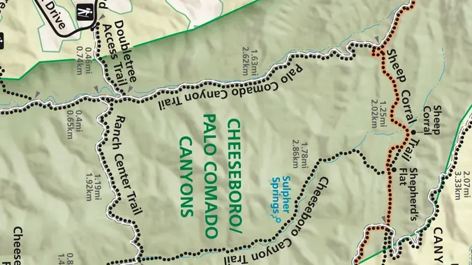
This week we’ll do a loop around the northeastern regions of the Santa Monica Mountains National Recreation Area and the Las Virgenes Open Space. This area traverses many ecosystems, including riparian, chaparral, and the rockscape from Galaxy Quest. The area is generally dry, but very nice! http://photos1.meetupstatic.com/photos/event/c/3/0/c/event_255709932.jpeg The trailhead is where Sunnycrest turns into Doubletree, […]

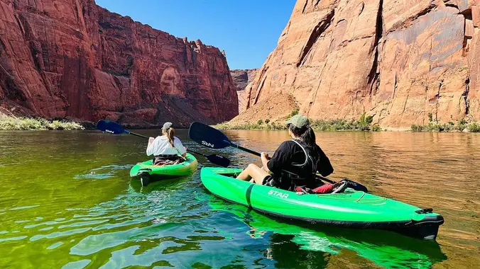
ARIZONA: Kayak Camping Horseshoe Bend (15 paddle miles)

Santa Paula Canyon Trailhead (Punchbowls) Santa Paula, CA, US

RSVP waitlist will be managed April 9th, 2024 at 7:00AM. 🌞 Bucket list trip! This is not a hiking or backpacking trip. This is an overnight via kayak on the Colorado River. You must be able to manage yourself and your transportation. This trip has minimal guidance. It may be possible to plan ridesharing by […]

Lizard Rock Loop

Tennis Court parking lot 635 W Avenida de Los Arboles, Thousand Oaks, CA, US

Easy Intermediate, 4.5 miles, 600' gain Easier Option, 3.5 miles, 460' gain This is a unique loop through Wildwood Park that takes us to the famous Lizard Rock. There are several extended inclines and a few short but steep climbs that cause this to be rated on the easy end of the intermediate spectrum. Beginners […]

Two Peaks in the Conejo Canyon Western Plateau (Fast Paced)

Thousand Oaks CNG Fueling Station 1993 Rancho Conejo Boulevard, Thousand Oaks, CA, US

http://photos1.meetupstatic.com/photos/event/9/9/3/6/event_278199222.jpeg Please read these restrictions before signing up. Don't show up unless you're shown on the "Attending" list Unregistered or waitlisted will be turned away No "Plus Ones" on this hike Welcome Trailblazers! Time to return to a favorite trail once again! Let's bag a couple peaks in our beautiful Western Plateau. We will do […]


Trail statistics are approximate. For safety purposes always assume they are underestimated. But don’t be disappointed if they are overestimated. Bring more water and snacks than you think you’ll need.

Trail descriptions are based on previous hikes. Current conditions are unknown until arrival. Expect the unexpected and plan accordingly.

The Organizers and members of Hiking With Dean are not professional leaders, guides, or mountaineers. The function of the member or organizer is only to organize the trip. Each person who shows up for a trip/meetup (and their guest or guests) is responsible for his or her own safety. By attending a hike, or any other event organized by this group, you are acknowledging that you and any guests that you bring are aware of the risks, dangers and hazards associated with the activity and freely accept and fully assume all such risks, dangers and hazards, and further agree to release and discharge the Organizers, Members of the Hiking With Dean Meetup Group from and against any and all liability arising from your participation in the group activities per our ASSUMPTION OF RISK AND LIABILITY WAIVER and Section 6.2 of the Meetup.com Terms of Service.