

Not for beginners-limited number of hikers. Rain cancels hike.
Important: Parking is limited and carpooling will help. Also, the parking area fills up early so please arrive on time. This location does require a National Forest Adventure Pass for parked vehicles.

The Stats
Distance: <12 miles round trip
Rating: 8/10
Elevation gain: 2500 ft.
Trail: Lollipop route, single track, asphalt, fire roads and no trail in the GC.
Duration: 6-7 hours

The Plan
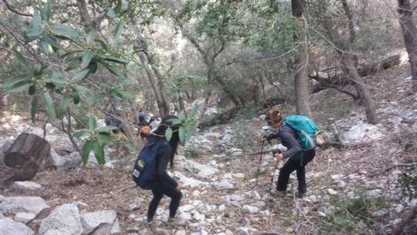
Below the slopes of Mount Lowe, the “Grand Canyon” is modest by the standards of the San Gabriels and certainly bears no resemblance to the famous ditch of the same name. The uphill leg of this adventure follows the path visitors once took on the Mount Lowe RR to get to the Alpine Tavern where our entry into the Grand Canyon begins. The off-trail hike down the length of the Grand involves the descent of several steep but short earthen slopes (most safely accomplished by sliding on one’s rear end), but is otherwise a quite straightforward off-trail hike. It involves a pleasant wooded canyon where there are several human artifacts of interest. At its terminus the Grand discharges into Millard Canyon where we’ll pick up a trail back up to the Sunset Ridge trail and our cars.

The Story
The portion of the Mt. Lowe Railway beyond Echo Mountain was the Alpine Division, which took visitors up to the Alpine Tavern for food and accommodations. The Alpine Division, according to the Pacific Electric Railway’s Employee’s Timetable, was 3.57 miles in length, and her longest stretch of straight track just 225’. Yet another highlight on the Alpine Division was Circular Bridge, about the halfway point to Alpine Tavern from Echo Mountain. This engineering fete was the brainchild of engineer David Macpherson, where the track completes a full circle and doubles back on itself at a higher level. Those that remember riding on this route in its heyday say this was the scariest part of the ride. Cars would periodically stop for souvenir shots. Upon arriving at Crystal Springs and Alpine Tavern, the terminus of the Alpine Division, one could have a bite to eat and stay the night. Other amusements in the area included hiking or horseback riding to the summit of Mount Lowe, billiards, miniature golf, tennis, viewing the silver fox farm, hiking up to Inspiration Point, riding the famous One Man and a Mule Railway, or just mingling with the visitors around the great fireplace.


Mt. Lowe Preservation Society (http://www.mountlowe.org/)
Thaddeus Lowe (http://www.thaddeuslowe.name/)
Directions:
To the Chaney Trail Gate: Exit the 210 fwy in Pasadena at Fair Oaks and go north to Loma Alta Dr. Turn left here and then turn right on Chaney Trail (flashing yellow light overhead). Take Chaney Trail to the top, you’ll see a gate to your right. Park here, but do not block the gate. continuing down the road past where the gate is will take you down to parking for Millard Campground. We are not meeting down there.
Check the Weather (http://www.wunderground.com/q/zmw:91001.1.99999)
*******************************************************************
The Fine Print
PLEASE – Know your limits and abilities. Bring snacks and drink plenty of liquids when hiking. Check weather conditions and dress accordingly and be aware of your surroundings at all times. Watching out for poison oak, snakes, ticks, uneven footing, spectacular views, beautiful fauna all while interacting with awesome (usually) fellow hikers can be extremely hazardous, rewarding and fun.
RSVP’s: If you RSVP for an event be responsible and update your RSVP if your plans change. If your plans change at the last second and you’re not able to update your RSVP also let us know. In my opinion a no-show is someone who has no regard for following the guidelines we request from our members and will risk being removed from future events that have a limit.
VHC HIKE RATING SCALE
Rating a hike is subjective, meaning the difficulty of a hike will be in direct relation to how often you hike and the type of hike you prefer. Keep in mind that any hike can have the following: un-even hiking surfaces, various obstructions, water and/or water crossings or bouldering and/or rock hopping. A great hike will have all of these!
1 – A long walk
2 – 4 mile hike w/little elevation gain
3 – 5 mile hike w/up to1000 ft. elevation gain
4 – 5+ mile hike w/up to1500 ft. elevation gain (heart rate increases at times)
5 – 7+ mile hike w/over 1500 ft. elevation gain (heart rate increasing even more at times)
6 – 7+ mile hike w/over 2000 ft. elevation gain (at times you might be trying to remember how to perform CPR)
7 – 5+ mile hike w/over 2000 ft. elevation gain (at times you might be muttering expletives to yourself)
8 – 10+ mile hike w/over 3500 ft. elevation gain (at times you might be angry with the hike leader)
9 – 10+ mile hike w/over 5000 ft. elevation gain (at times you might be thinking of reporting the hike leader to the authorities)
10 – Use your imagination
Class 3 Scrambling: Scrambling or un-roped climbing. You must use your hands at times to hold the terrain or find your route. This may be caused by a combination of boulders, steepness and extreme terrain. Some Class 3 routes have ropes in place for assistance.
DISCLAIMER / RELEASE OF LIABILITY
IMPORTANT, PLEASE READ BELOW IN ITS ENTIRETY:
I am a volunteer (i.e. not liable for the group). Safety is a priority for everyone in the group. Think of this as hiking with a group of friends.
Outdoor sports and other events we plan can be inherently dangerous and accidents may happen. By participating in any posted event, you’re taking responsibility for your own safety and well-being. The Valencia Hiking Crew Meetup Group and its organizers are not trained leaders and we do not confirm the qualifications of any of its members to lead or participate in trips. All participants take full responsibility for their own actions. If you choose to sign up for any Valencia Hiking Crew Meetup events, you are releasing the Valencia Hiking Crew Meetup Group and it’s organizers from all liability in case of possible injuries as stated in paragraph 6.2 of the Meetup “Terms of Service” located on the bottom of the Meetup website. Your personal safety depends on your own judgment and experience.


