

I like finding hikes close to home that aren’t always on other people’s radar. This is the best description of the hike to “Mount Camelback” I’ve found:
Officially, as far as I’ve seen on any map, there is no such place. The Sunland US Topo map does not list this mountain. Really it’s more part of a ridge than a peak but from certain angles, it does look like the back of a camel due to its pronounced humps. It has been known by this name by the locals for many decades. Camelback can be aproached most directly from the Haines Debris Basin, though it is far from a quaint afternoon hike in the hills.
THE PLAN
THERE IS A VERY STEEP SCRAMBLE RIDGE. Please read the write up and stats before signing up.
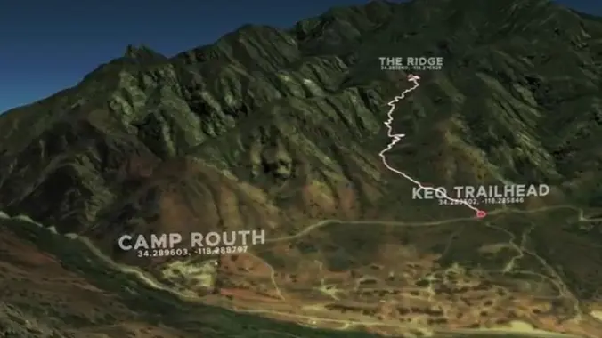
We will start at Haines Cyn and follow a trail along the foothills that will allow us a bit of a warm up before the fun begins. Three miles in, we will meet up with the Kill ‘Em Quick trail. Here we will gain over 1000’ of elevation in just one mile. There are about 30 switchbacks that will lead us to a ridge. Be prepared for rock scrambling. The plan is to connect to Camelback – a point we reached last year that has amazing views of the valley and surrounding areas. This is where we’ll take our lunch break before heading down a couple miles of steep trail back to our cars.
There will be a couple places to stop, catch our breath, take in the views and regroup.
Important notes:
EXPLORATORY
BUSHWHACKING
BRING POLES
MORE WATER THAN YOU THINK YOU’LL NEED
EXTRA TIME TO FIND PARKING – SEE FARZAN RULE
VERY, VERY STEEP
STATS
Distance: 8 Miles
Elevation Gain: 2500 ft
Duration: 5 hours
Trail: Fire road and single track, w/areas of deteriorating trails and steep, uneven downhills, possible bushwhacking
Rating: 7/10, due to trail condition and gain
Parking pass: Not needed
Not for beginners – no sweep!! We’ll be keeping a moderate pace and regrouping as needed.
THE STORY
A couple of local residents made some cool videos of their crazy adventures. One of them was an exploration of an abandoned detention center and the trail the juvenile detainees maintained as part of their training program:
“The Kill ‘Em Quick Trail was built by juvenile offenders detained at nearby Camp Routh, a LA County probation department fire camp, abandoned in 2009. Camp Routh had a program that trained some of the detainees to fight forest fires. As part of the training requirements, these detainees had to make it up the ridge in under 30 mins wearing their forest fire gear, some carrying chainsaws.
“In one of the abandoned buildings, there’s an old whiteboard with the Kill ‘Em Quick climber rankings, a competitive list of times between detainees, staff and the fire department.” One of the probation officers set the record with a time of just 15 minutes.
A couple quotes that will let you know what you’re in for: “Is this even a trail?” “This trail won’t last if people don’t use it.” “This trail is gnarly.” Sounds like a VHC hike to me.
DIRECTIONS
From the 210 fwy take the Lowell Ave exit to Honolulu Ave. Go west. It veers right and turns into Tujunga Cyn Blvd. In just over a mile and a half turn right on Haines Cyn Ave. Make a right on Day St and a left to join Haines Cyn again. Though we will be meeting at the very end of Haines, there isn’t much parking there so grab any available parking spot you see when you’re on Haines or turn left on Apperson St to look for a spot.
We will meet at the gate at the end of Haines. Please keep in mind this is a residential neighborhood – keep any noise to a minimum.
*** Allow yourself a few extra minutes to find parking and walk to the trailhead.
**************************
**************************
The Fine Print
PLEASE – Know your limits and abilities. Bring snacks and drink plenty of liquids when hiking. Check weather conditions and dress accordingly and be aware of your surroundings at all times. Watching out for poison oak, snakes, ticks, uneven footing, spectacular views, beautiful fauna all while interacting with awesome (usually) fellow hikers can be extremely hazardous, rewarding and fun.
The Farzan Rule: Posted hike times are the time the hike starts or we leave from a posted shuttle location. I’m aware other Meetup groups offer a grace period for late arrivals; we don’t. It’s your responsibility to know the location of the meeting spot and be there and ready to participate at the posted time. If you have any concerns about the directions feel free to contact the organizer of the event, preferably in advance of the event and not at the start time. I’m of the opinion that it’s not fair to delay an event when the majority of attendees have arrived on-time. (so named after a conversation I had with a certain un-named member)
RSVP’s: If you RSVP for an event be responsible and update your RSVP if your plans change. If your plans change at the last second and you’re not able to update your RSVP also let us know. In my opinion a no-show is someone who has no regard for following the guidelines we request from our members and will risk being removed from future events that have a limit.
VHC HIKE RATING SCALE
Rating a hike is subjective, meaning the difficulty of a hike will be in direct relation to how often you hike and the type of hike you prefer. Keep in mind that any hike can have the following: un-even hiking surfaces, various obstructions, water and/or water crossings or bouldering and/or rock hopping. A great hike will have all of these!
1 – A long walk
2 – 4 mile hike w/little elevation gain
3 – 5 mile hike w/up to 1000 ft. elevation gain
4 – 5+ mile hike w/up to 1500 ft. elevation gain (heart rate increases at times)
5 – 7+ mile hike w/over 1500 ft. elevation gain (heart rate increasing even more at times)
6 – 7+ mile hike w/over 2000 ft. elevation gain (at times you might be trying to remember how to perform CPR)
7 – 5+ mile hike w/over 2000 ft. elevation gain (at times you might be muttering expletives to yourself)
8 – 10+ mile hike w/over 3500 ft. elevation gain (at times you might be angry with the hike leader)
9 – 10+ mile hike w/over 5000 ft. elevation gain (at times you might be thinking of reporting the hike leader to the authorities)
10 – Use your imagination
Class 3 Scrambling: Scrambling or un-roped climbing. You must use your hands at times to hold the terrain or find your route. This may be caused by a combination of boulders, steepness and extreme terrain. Some Class 3 routes have ropes in place for assistance.
DISCLAIMER / RELEASE OF LIABILITY
IMPORTANT, PLEASE READ BELOW IN ITS ENTIRETY:
I am a volunteer (i.e. not liable for the group). Safety is a priority for everyone in the group. Think of this as hiking with a group of friends.
Outdoor sports and other events we plan can be inherently dangerous and accidents may happen. By participating in any posted event, you’re taking responsibility for your own safety and well-being. The Valencia Hiking Crew Meetup Group and its organizers are not trained leaders and we do not confirm the qualifications of any of its members to lead or participate in trips. All participants take full responsibility for their own actions. If you choose to sign up for any Valencia Hiking Crew Meetup events, you are releasing the Valencia Hiking Crew Meetup Group and it’s organizers from all liability in case of possible injuries as stated in paragraph 6.2 of the Meetup “Terms of Service” located on the bottom of the Meetup website. Your personal safety depends on your own judgment and experience.


