

BEFORE YOU WILL BE MOVED TO THE GOING LIST, YOU WILL NEED TO UPDATE YOUR CDH PROFILE (The three questions must be answered with a “yes”) IF YOU HAVE NOT ALREADY DONE SO.
NEED HELP:
go to: [https://wp.me/P9MbG4-hC](https://wp.me/P9MbG4-hC)
SANTA BARBARA COAST- SERIES OF HIKES
Join me on yet another CDH series as I take on the Santa Barbara Coastal Range. We’ll hike a series of trails we’ve taken before that will be interesting with views of the ocean on most of them. Starting north at Gaviota, we’ll conclude the series in Montecito. This series is definitely meant to be more visual than physical, thus, less conditioning but more of a mental enlightenment. Therefore, we will hike together as a group and enjoy the beauty that this series offers.
THE PLAYGROUND
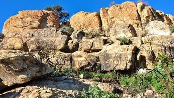
This 5th trek in the Santa Barbara series will take us to The Playground. It’s the name of a large area with many rock towers and subterranean rock formations in the Santa Ynez Mountains of Santa Barbara. It’s about a half mile hike to the Playground with some steep areas along the way. We’ll spend the day exploring all the nooks and crannies this place offers. It’s a must for those that like to explore and rock scramble. Parking is limited in this area, so it helps to car pool there. The awesome views below of Santa Barbara’s coastline is another reason to come out and enjoy this area with us. After the hike, you can join me for an optional late lunch debriefing.
INITIAL MEETUP LOCATION, DIRECTIONS AND TIME: The Thousand Oaks Park and Ride at the corner of Rancho Rd. and Haaland Dr. NO LATER THAN 7:30 a.m. It’s just south of the 101 Fwy and 23 Fwy interchange. Have a full tank of gas and be willing to drive if needed. Those that don’t drive can help pay for gas. It’s about 1.2 hour’s drive to the trailhead.
FINAL MEETUP LOCATION AND TIME: The Playground no later than 9:00 a.m. IT’S HARD TO FIND
[https://www.google.com/maps/place/34%C2%B030’04.4%22N+119%C2%B051’48.5%22W/@34.5012141,-119.8656519,17z/data=!4m5!3m4!1s0x0:0xa0c214df2ad4e802!8m2!3d34.5012141!4d-119.8634632](https://www.google.com/maps/place/34%C2%B030’04.4%22N+119%C2%B051’48.5%22W/@34.5012141,-119.8656519,17z/data=!4m5!3m4!1s0x0:0xa0c214df2ad4e802!8m2!3d34.5012141!4d-119.8634632)
DISTANCE: 4 miles of exploratory rock scrambling around, over and under huge boulders.
ELEVATION GAIN/LOSS: 1000’/1000′
THE PACE: As fast as the slowest Trekker
DURATION: 5 hours of ecstasy for our WWW members
TERRAIN: Single track use trails and lots of rock scrambling
LEVEL: Intermediate Trekker who loves exploring rock formations
OPTIONAL LUNCH: After the hike, I will be debriefing at the Crushcakes and Cafe for lunch
5392 Hollister Ave, Goleta
MENU: [https://www.crushcakes.com/menu/#cafe-lunch](https://www.crushcakes.com/menu/#cafe-lunch)
MY CELL# IS: 805-358-5972


