

3 miles. 560′ gain, fit beginner (5:30, not 6p)
Note the time change. This park closes at sunset, so we try to get out by then. For this reason, on weekdays, I only schedule this in the summer when sunset is late.
Free parking is limited. Carpooling recommended.
As of June 2. 2022, the first part of the clockwise loop was closed, but we found a new and cooler route with a perfect place for a snack-share, complete with picnic table.
We’ll head up the ramp and begin the hike counter-clockwise. This ramp will be the only significant incline, but is still suitable for fit beginners It is paved, runs 1/4 mile, and about 125′ of gain.
As we continue, there will be a trail junction heading to the right and behind the rocks. For this hike, we may or may not go up on the rocks to a secret area where the rock has been carved out. Maybe some will and the rest won’t.
We’ll continue on the main trail and follow it the rest of the way around. When we come to a sign that says “detour” because the path forward is closed, we’ll take the detour.
Shortly after the detour starts, there will be a picnic table to the right. We’ll stop there for a social event. Please bring snacks and drink to share.
This time of year, there can be insects. Long pants and your preferred bug spray are recommended.
It is a steady climb up most of the way back, but fit beginners can handle it. It will eventually lead us back to the top parking lot. From there, we’ll take the asphalt path and down to our cars.
Note that we have been scolded in the past by the ranger for being on the trail after dark here, so we’ll try to get back to our cars by dark, else get permission.
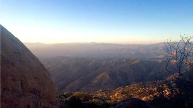
This takes us through Sage Ranch Park, with interesting rock formations all around, a very cool overlook onto the valley at the half way point, and even an overlook onto part of the old Santa Suzanna nuclear test facility.
About the parking
There are two spots to park. The first (where we will meet), is right at the entrance along the west edge of Black Canyon Rd. This is a free gravel lot, but parking is limited to about 30 cars.
If the free lots gets filled, continue about 500′ west up a steep incline, where there is another lot with payment required via self-pay envelopes. If you plan on parking in this lot, bring exact change from $5-15, as I’m not sure of the cost.
First, we’ll walk up to the upper lot. You can wait up there if you don’t want to make the climb from the lower lot.
The park is officially open from sunrise to sunset. Prior postings for this hike, had this warning: If you do park in the pay lot, be sure you return before sunset, else risk a ticket or being locked in by a ranger.
Interesting Notes
Multiple brown buttons going up the top of the stalk, that may have white flowers. Green leaves. Purple or white flowers that are dark brown as they dry on the plant. Squish the leaves and smell.
A rare and sought after Black sage honey is also made from the honey of bees that pollinate the Black sage plant. Black sage is utilized in the culinary world as an aromatic and flavorful herb. It can be used in recipes wherever traditional sage is called for, however keep in mind that foraged Black sage has a much stronger flavor than that of traditional store bought sage.
Its flavor marries well with winter squashes, brown butter, poultry, venison, pears, cheese, potatoes and other herbs such as rosemary and thyme. Use fresh in a variety of different preparations or leaves can be dried and stored for future use as a dried herb. Black sage was used traditionally by Native Americans known as the Chumash people to form an herbal soak for the bath to be used in the treatment of bodily pain, specifically for the feet and lower legs.
Yerba Santa
Saint Herb, Holy Plant, Mountain Balm.
The Spanish who came to early California were so impressed with the plant that they gave it the name Yerba Santa.
Leaves were chewed to relieve dry mouth. Leaves were smoked or chewed to relieve asthma, coughs, colds, headaches, and stomachaches. Infusions of Yerba Santa leaves and flowers were used to treat fevers, coughs, colds, stomachaches, asthma, rheumatism pleurisy, chronic bronchitis, tuberculosis, and to purify the blood. Heated leaves were placed on the forehead to relieve headaches and other aches and sores.
The sticky leaves stay in place upon the skin. Mashed leaves were applied externally to sores, cuts, wounds, insect bites, and aching muscles. Mashed leaves were also used to reduce the swelling and relieve pain caused by bone fractures. The branches and leaves were burned in steam baths to treat rheumatism and hemorrhoids. Contains chemicals that are thought to loosen mucus in the chest and may increase urination.
Distance: 3 miles
Duration: 3.5 hours
Elevation Gain: 560′
Difficulty: Fit Beginner
Pace: 2.0 mph
Dogs: Yes.
Restrooms: Yes, at the upper parking lot, which we will be walking up to at the start of this hike.
Drinking Fountains: Yes, at the start, but you have to walk down into the picnic area to get to it.
Parking: Free in the gravel lot, $? to park up the incline at the top, cash only.
Trail: Fire Road and rocky trail, good condition.
What to Bring:
1-2 liters of water.
[Snacks and/or beverages to share]((https://www.meetup.com/Hiking-Plus/messages/boards/thread/50879772)
Hiking shoes preferred, but athletic shoes will be OK.
Flashlight or headlamp. The last 30 minutes may get dark.
Directions
Sage Ranch Loop Trail
1 Black Canyon Road
Simi Valley, CA 91304
Coordinates: 34.241330, -118.671742
From the 118
Exit Topanga Canyon and head south for 2.5 mi.
Right (west) on Plummer St. for 09. mi.
Continue as the road curves left, becoming Valley Circle Blvd. and then Lake Manor Dr. for 1.2 mi.
Left (south) on Valley Circle Blvd. (do not continue onto Box Canyon Rd.) for 500′.
Right (west) on Woosley Canyon Rd. up the winding hill for 2.5 mi.
Right (north) on Facility Rd. for 500′.
Left (west) into lot.
Free parking is on left, paid parking is up the incline at the end.
From the 101
Exit Valley Circle and head north past Roscoe Blvd. for 5.9 mi.
Left (west) on Woosley Canyon Rd. up the winding hill for 2.5 mi.
Right (north) on Facility Rd. for 500′.
Left (west) into lot.
Free parking is on left, paid parking is up the incline at the end.
From Simi Valley
E. Los Angeles east of Yosemite Ave. for 0.5 miles
Right (south) on Christine Ave. for 0.5 miles
Right (west) on Katherine Rd. for 0.1 miles
Left (south) on Katherine Rd. for 0.2 miles
Right (west) on Katherine Rd./Oak Knolls Rd. (last right before end) for 0.1 miles
Left split onto Black Canyon Rd. for 1.9 miles
Note that this road gets very narrow. Go slow – 15 mph or less.
Free parking on right at intersection with N. American Cut off Rd., paid parking is up the incline at the end.


