

4.6 miles, 900′ gain, easy-intermediate.
This route takes us through a beautiful canyon via a counter-clockwise lollipop. Most of the hike has a clear view of the sky, with a few parts that have tree cover. We’ll be stopping at the half-way point for a snack and beverage share (https://www.meetup.com/Hiking-Plus/messages/boards/thread/50879772).
We’ll start at the Palo Comado Canyon – Doubletree Trailhead (coordinates: 34.182480,-118.751785) and head east for 1/2 mile along the Doubletree Connector Trail. We’ll turn left and head north along the Palo Comado for about 1 mile. We’ll turn right (east) onto the Dead Cow Trail for 0.8 miles, where we’ll come to an overlook on the left.
There, we’ll stop for a snack and beverage share (https://www.meetup.com/Hiking-Plus/messages/boards/thread/50879772). Then we’ll continue down the Sheep Corral trail for about 700′, turning left back onto the Palo Comado trail. From there, we’ll head south 1.75 miles and turn right (west) onto the Doubletree Connector Trail and the final 1/2 mile back to the trailhead.
Hike
Distance: 4.6 miles
Gain: 900′
Distribution: Most of the incline well distributed in the first half.
Difficulty (https://www.meetup.com/Hiking-Plus/messages/boards/thread/50879781): Easy Intermediate.
Shape: Lollipop, counter-clockwise.
Pace: approx. 2.0 mph.
Trail Type: Fire road and single track. Areas of sand, gravel, and rock, some of it rugged.
Trail Variations:
Several extended inclines of 1000 steps.
Several steep sections of 300 steps, but no hands required.
Duration: 3.5 hours
Dogs: Yes.
Restrooms: No
Drinking Fountains: No.
Parking: Free along street.
What to bring:
1 liter of water for every 3 miles.
Hiking shoes/boots
Flashlight or headlamp.
Sunscreen and/or hat as needed.
Snack and Beverage Share (https://www.meetup.com/Hiking-Plus/messages/boards/thread/50879772)
Hosting
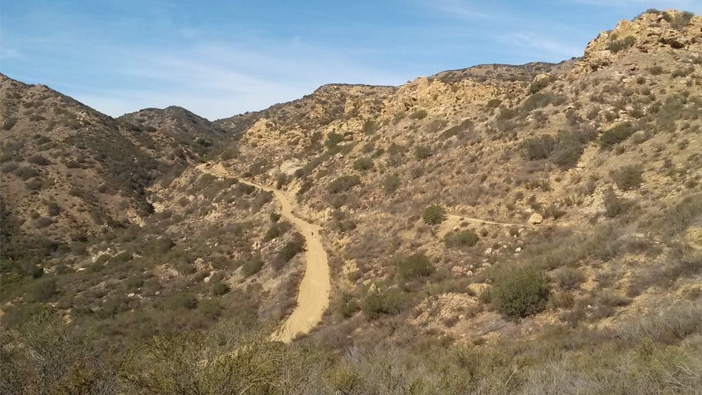
Route: The host knows the route. A pic of the route has been posted as part of this description.
Navigation: Host memory, enhanced by GPS navigation as needed.
Hike type: Social.
We won’t be hiking at a fast pace because this is a social hike, not a conditioning hike. There is nothing wrong with stopping, even if it means every 50 steps. See “How hard is this hike” in the discussion section (LINK (https://www.meetup.com/Hiking-Plus/messages/boards/thread/50879781)).
Stops:
The host may designate stopping points to let others catch up. This hike will include an extended stop for a snack and beverage (https://www.meetup.com/Hiking-Plus/messages/boards/thread/50879772) share at the half way point. We will stop at junctions to make sure everybody makes any turns or chooses the correct direction at splits, else something will be used to mark the direction, usually a large arrow made of baking soda or some sticks. There may not always be a sweeper designated to be the last hiker.
Each hiker is responsible for knowing their capability, only attending events where they are able to sustain the described pace, for keeping up with the group sufficiently enough to make the turns and not get left behind, and for making sure the host is notified if they are going to split from the group.
Group separation:
Sometimes hikers wish to move significantly ahead and not wait at designated stopping points. Please let the host know. They are on their own regarding route and navigation.
Interesting Notes
Here are a couple plants you are sure to see on this hike:
Black Sage
Multiple brown buttons going up the top of the stalk, that may have white flowers. Green leaves. Purple or white flowers that are dark brown as they dry on the plant. Squish the leaves and smell.
A rare and sought after Black sage honey is also made from the honey of bees that pollinate the Black sage plant. Black sage is utilized in the culinary world as an aromatic and flavorful herb. It can be used in recipes wherever traditional sage is called for, however keep in mind that foraged Black sage has a much stronger flavor than that of traditional store bought sage.
Its flavor goes well with winter squashes, brown butter, poultry, venison, pears, cheese, potatoes and other herbs such as rosemary and thyme. Use fresh in a variety of different preparations or leaves. Can be dried and stored for future use as a dried herb. Black sage was used traditionally by Native Americans known as the Chumash people to form an herbal soak for the bath to be used in the treatment of bodily pain, specifically for the feet and lower legs.
Yellow Star Thistle
Thorny. Also called yellow cockspur and golden star thistle. Generally considered a weed. Long-term ingestion by horses causes a neurological disorder known as chewing disease, a lethal lesion of the nigropallidal region of the brain. This disease is expressed as a twitching of the lips, tongue flicking, and involuntary chewing. Permanent brain damage is possible, and affected horses may starve to death. Used in Turkish folk medicine for the treatment of ulcers. In a laboratory study, aqueous extracts of fresh or dried flowers of yellow star thistle given orally showed significant antiulcerogenic activity in rats.
Directions (Palo Comado Canyon – Doubletree Trailhead):
From I-101:
I-101, exit Kanan Rd.
Kanan Rd. north for 2 miles.
Right (east) on Sunnycrest Dr. for 0.6 miles.
Continue on Doubletree Rd. for 0.l miles.
Trailhead on the right, park along the street.
From CA-118, CA-23:
I-118 west.
I-23 south for 4.8 miles, exit Avenida de Los Arboles.
Left (east) on Avenida del Los Arboles for 1.6 miles.
Right (south) on N. Westlake Blvd for 1.5 miles.
Left (east) on Kanan Rd. for 4.2 miles.
Left (north-east) on Deerhill Rd. for 0.3 miles.
Right at second cross street onto Doubletree Rd for 0.5 miles.
Trailhead on the left, park along the street.
Coordinates of trailhead: 34.182480,-118.751785
Address of a nearby house: 713 Quail View Court, Oak Park, CA 91377
Release of Liability:
https://www.meetup.com/Hiking-Plus/pages/29622459/Is_Hiking_Dangerous/


