

BEFORE YOU WILL BE MOVED TO THE GOING LIST, YOU WILL NEED TO UPDATE YOUR CDH PROFILE (The three questions must be answered with a “yes”) IF YOU HAVE NOT ALREADY DONE SO.
NEED HELP:
go to: https://wp.me/P9MbG4-hC
Nightmare Gulch Loop
Distance: 8-9 miles
Elevation Gain: 1600 feet
Leader: Nikki
While it is possible to camp overnight in Red Rock Cyn State Park at the Ricardo Camp Ground, this event is planned as a day hike following a drive in. Anyone wishing to camp overnight should make their own arrangements for camping.
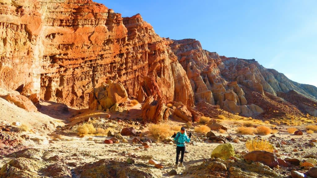
Red Rock Canyon State Park features scenic desert cliffs, buttes and spectacular rock formations. The park is located where the southernmost tip of the Sierra Nevada converge with the El Paso Range. Each tributary canyon is unique, with dramatic shapes and vivid colors.
We will begin our 9 mile loop by climbing to the top of the first of three ridges (which will account for most of the elevation gain and some easy scrambling) that allow great views of the Sierras to the north and the Gulch to the south. We will descend from the third ridge, and enter the east end of the gulch for an easy mostly level hike enjoying spectacular rock formations all around us until we emerge from the west end and have a final ascent to return back to the trailhead.
Nightmare Gulch is a small, colorful, highly scenic canyon. The area attracts many birds of prey. To protect the raptor nesting sites, this area of the park is closed to hikers and vehicle travel yearly from February 1 to July 1. The gulch has many side slot canyons just waiting to explore. Along the way, we will turn into one to view a specific rock formation called Magic City.
Please be aware that there is NO established trail for this route and the hike will be cross-country through a desert environment. It will be important that hikers do not fall too far behind the leader.
Dogs are not allowed on established trails, however, as we will not be following an actual trail, they are okay for this hike. Park rules state that dogs must remain on a 6-foot maximum leash and be accompanied by a person at all times. They must be cleaned up after and cannot be left unattended.
Bring a lunch, snacks, and adequate water (3 liters) for a desert hike. It may be very cold and windy in the morning, so dress WARMLY, but in layers that can be removed as the day goes on.
Directions
The park is 120 miles north of Los Angeles, via Interstate 5 and Highway 14 and 25 miles northeast of Mojave on Highway 14, near Cantil. From Highway 14, there is a clearly signed turnoff to Abbott Drive where the Ricardo Campground is located. We will meet at the trailhead, which is a dirt turnout apx ¾ of a mile north of the Abbott Drive turnoff on the right hand side. It is the only obvious pull out for parking from Highway 14. While not clearly marked it should be somewhat obvious. Google maps also shows the parking area as Red Rock Canyon SP North parking lot.
Park map showing trailhead location is also attached as a photo.
Folks who would like to carpool can meet at the Starbuck’s restaurant parking lot at 16548 Soledad Canyon Road, Santa Clarita, CA 91387, off of the Sand Cyn exit on Highway 14 in Santa Clarita.
Meet at the carpool location by 6:00 AM for 6:15AM departure. The carpoolers will stop for a final bathroom break at the Carl’s Jr in Mojave. Anyone driving directly to the trailhead should plan to meet there at 8:00 AM, however carpooling is encouraged as there is limited parking at the trailhead.


