

BEFORE YOU WILL BE MOVED TO THE GOING LIST, YOU WILL NEED TO UPDATE YOUR CDH PROFILE (The three questions must be answered with a “yes”) IF YOU HAVE NOT ALREADY DONE SO.
NEED HELP:
go to: https://wp.me/P9MbG4-hC
Before the rain and snow hits this area and while it’s nice and cool, I’m planning on taking on Mount Baden Powell via The Big Horn Mine.
THIS EVENT WILL INVOLVE 2.75 MILES OF VERY STEEP OFF TRAIL HIKING ALONG RIDGES and 2.75 miles of trails. Don’t let the low mileage fool you, this will be a great conditioning hike. You’ll be taking on Mt. Baden Powell as so few have ever done before.
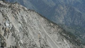
THE TREK: From The Vincent Gap parking area at 6585’ (mile marker 74.80), we will hike along an easy 400’ gain in elevation over 2 miles to The Big Horn Mine, which we can explore for awhile. From there the route to the top of Mt. Baden Powell along its eastern backbone is the most challenging and by far most avoided, in fact, it’s not even listed in The Sierra Club’s routes to the top. This no nonsense kick in the @$$ cross country route will require a person with legs of steel and fearless of heights. This steep backbone at times resembles a knives edge with steep drop offs into the huge bowl of Mine Gulch, and it makes the backbones of Mt. Baldy look meek in comparison. Once at the top, we will break for a well deserved lunch for at least an hour, savoring over our accomplishment. From here we will descend yet another off trail ridge back to Hwy. 2. This event is accomplished by way of a short 2 mile car shuttle.
MEETUP LOCATION AND DIRECTIONS AND TIME: From the 210 Fwy, exit at Angeles Crest Hwy and drive north about a quarter mile to just past Milmada Dr. in LA CANADA, then park alongside the road. We will all meet here no later than 7:00 a.m. and car shuttle up Angeles Crest Hwy. 2 to (mile marker 73.00). From there we will shuttle over to Vincent Gap parking area (mile marker 74.80) to begin our trek. An Adventure Pass will be needed to park on Hwy. 2 at Vincent Gap.
DURATION: This will be an all day event, so if you have to be back at a certain time, then please don’t sign up.
TERRAIN: A very very steep ridge which will make Register Ridge seem easy.
DISTANCE: 5.5 extremely challenging miles at times
ELEVATION RANGE: From 6585′ to 9399′ with an overall gain of 3000′.
THE PACE: 2 MPH moving pace on the 2+ miles of trails and what ever pace it takes on the ridges with several breaks along the way.
LEVEL: Wednesday’s CDH core group and advanced intermediate Trekkers.
SUGGESTIONS: Bring lots of water, since this will be a very demanding trek up the ridge. Having trekking poles and micro spikes will help. It’ll be cold, bring gloves and layered clothing.


