

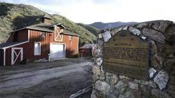
DESCRIPTION: We’ll start from Mentryville (a historic SCV site) located at the base of Pico Canyon’s slopes, Mentryville was an 1880’s oil boom town built around its oil well, Pico No. 4. Named for Charles Mentry, historic buildings still stand including a thirteen-room mansion, a one-room schoolhouse, and a barn. Mentryville and Pico No. 4 are registered as California State Historical Landmarks.
The beginning of the hike is on an asphalt road which yields to a fire road and untimely a single-track trail. Pico Canyon Trail is another one of the local gems where in a just a short hike you’re miles from a busy modern life and into the wide-open spaces of the near back country enjoying nature with great views.
Hike leader volunteers: Tim R. + Gary S.
Meet: Mentryville Parking lot where Pico Canyon Road ends at 8:00am, departure at 8:15 am sharp. (Mar 2)
Distance: Approximately 6.8 miles.
Elevation gain: Approximately 1,272 feet.
Time: Approximately 3.5 hours hiking including one snack break (brisk pace).
Conditioning: You need to be in generally good physical condition (this is not a beginner hike).
Dogs: Must be on leash.
Restrooms – Yes at the park.
Adventure Pass: Not required.
WARNINGS:
- No stream crossings.
ESSENTIAL GEAR:
· Hiking shoes/boots/poles.
· Layers recommended. Bring warm jacket.
· Snacks and 2+ liters of water and electrolytes or salt tablets; camera, hat and sunscreen.
THIS HIKE RANKING: Level 3, Intermediate (see chart below):
CHC HIKE RANKING SCALE – Consider your capabilities before RSVP’ing for a hike to ensure you are properly conditioned for that hike:
1) Beginner: 1-3 miles, less than 500 feet elevation gain.
2) Beginner/Intermediate: 1-7 miles, less than 700 feet elevation gain.
3) Intermediate: 5-10 miles, 1000-2000 feet elevation gain.
4) Intermediate/Advanced: 7-12 miles, up to 3000 feet elevation gain.
5) Advanced: 10-17 miles, 3000 feet or more elevation gain.
TRAILHEAD LOCATION:
Mentryville Park:
27201 Pico Canyon Rd #1804, Stevenson Ranch, CA 91381
Directions to Trailhead
There is parking for a $5 fee. There is also limited “no fee” parking outside the park which adds approximately a quarter mile (each way) to the hike. This is a local hike and drive time should be short.
FILE DOWNLOADS
We highly recommend AllTrails or GAIA and What3Words apps be installed on your cell phones!
GPS Trail Map (link for downloadable mobile version)
Recommended Gear List for Hiking and Survival Safety (link)
The Community Hiking Club is a Non-Profit 501C3 organization. We rely on donations to continue sponsoring hikes like this. Please contribute by donating via: Cash contribution (at each hike), or via Zelle at 6617135610; or via Venmo at: @Heidi-Webber-5
DISCLAIMER / RELEASE OF LIABILITY – IMPORTANT, PLEASE READ BELOW IN ITS ENTIRETY:
When you sign up for this event, you are releasing Community Hiking Club from any liability or responsibility with your participation in this group activity. While safety is a priority for everyone in the group, hiking can be inherently risky. By participating in any posted event, you are assuming responsibility for your own safety and well-being. The Community Hiking Club (CHC) Meetup Group and its organizers and hike leaders are not trained leaders and we do not confirm the qualifications of any of its members to lead or participate in our events. All participants take full responsibility for their own actions. If you choose to sign up for any Community Hiking Club Meetup events, you are releasing the Community Hiking Club Meetup Group and Hike Leaders from all liability in case of possible injuries or death as stated in paragraph 6.2 of the Meetup “Terms of Service” located on the bottom of the Meetup website. Your personal safety depends on your own judgment and experience. If you sign up for this hike, you are verifying that this hike is within your abilities.


