

https://www.alltrails.com/trail/us/california/magic-mountain
Hello Fellow Hikers,
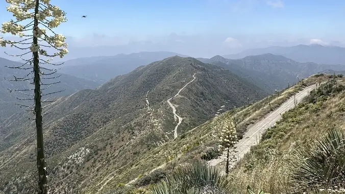
This little known trail is where Magic Mountain theme park got its name. It’s a constant climb that peaks at 4,846 ft. And as per several descriptions, this was once the site of the radar for the nuclear-tipped Ajax missiles in the 1950s. After the missiles were decommissioned, it was used as a test site for the control thrusters on the Apollo Lunar module. Magic Mountain’s “remote” location was ideal “for rocket testing with highly reactive and/or toxic propellants.” Remnants of the test site — the water tanks and the test beds — are still visible. Afterwards this road was used for OHV but has now been taken back by mother nature so its a old paved road. Some of the road has been washed away but we follow the path that’s not on this section of road. Vehicles are no longer permitted on this trail and it is used mostly by hikers, runners and MB. Once at the top there is a peak marker and the communication towers but those that have been here, stated the views on top is why you hike here. Carpooling at our same meetup spot will be offered for anyone who wishes to carpool or follow to the trailhead (Best donuts located 2325 Kuehner Dr # 127 Simi Valley off the 118 freeway at 9:15 am) have attached the AllTrails link for directions, pics, and stats…https://www.alltrails.com/trail/us/california/magic-mountain
Trail out and back
Miles 14.4
Elevation Gain 2506 ft
Rated hard
Dogs allowed but must be trained for longer harder hikes
Parking paved lot and side dirt road the ranger site doesn’t specify whether you need an Adventure Pass but have one just incase.
As of now there is no sweeper for this hike so please know if you feel you can not finish for any reason please turn back early
Please check back on hike info as rain, heat advisory, strong winds or low attendance may cause the hike to be rescheduled
Golden rules:
- Hike your own hike
- Please stop at every junction and split to wait for others to catch up
Please remember to bring all essentials you’ll need for a hike (water,hat,sunglasses,hiking boot/hiking shoes poles if needed snacks)
Liability Disclaimer:
And last….The Organizer, Co Organizer, Assistant Organizers and Event hosts in this group are not professional guides. The function of the Organizer is only to organize the trip. Each person who signs up for an Event is responsible for his or her own safety and the safety of his or her guest. Remember this is your hike. All responsibilities are of your own once you attend. Please be aware of your limit. During outdoor activity you can encounter bodily injury, snake bites, sunburn, overheating, etc. This is not within our control and we ask that you are prepared for any of the above once you sign up for an Event. If you need to take several breaks (not counting quick breather breaks) and stops throughout a hike, the hike maybe too much for your ability. Please check each event for miles, elevation gain, and difficulty rating. The higher the elevation gain means more incline and less leveled off sections. We offer all levels of hikes from moderate to hard to advanced only. We encourage everyone to not give up work on your core by joining our easier moderate Events and then joining our harder hikes once you are ready. 😊


