

5 miles, 800′ gain, Easy Intermediate.
Easier Option: 3.2 miles, 400′ gain, Fit Beginner.
The address is not the address of the hike, but a nearby address that should get you to pass by the trailhead.
We’ll be stopping at various points to regroup and this is not a conditioning hike. It is a social hike.
We will start by heading the back way from the Long Canyon trailhead parking lot and around to an asphalt road. At this point, if you want a shorter hike, turn left for 0.6 miles and 220 feet of gain, arriving at the Rockuzzi on the left.
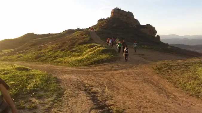
Otherwise, we’ll make our way down to the Autumn Ridge trail, make a left, then head for almost a mile up to the five-points junction. We’ll make a sharp left, then another left after about 500′ at the bench, heading up 50 yards and then down the Sunrise trail.
After about 1000′, we’ll head into the rocks into or next to the Rockcuzzi, a natural circular indentation in the rocks, hidden from view unless you know where it is, for a snack share social event for 30-60 minutes.
Finally, we’ll continue down the Sunrise trail, take the Woodridge Loop trail back to the asphalt road, then head back the way we came along the Woodridge Connector back to the trail head parking lot.
Interesting Notes
Smashed leaves can be thrown into the water to stupefy fish, causing them to float to the surface, a practice illegal in most states. The seeds are not toxic to birds and are enjoyed especially by doves and wild turkeys.
Ancient Greeks rolled and dried the leaves, then used them as wicks for oil lamps. It stalks were used as torches burned at funerals. Many tribes employed the use of mullein leaf tea for coughs, colds, and rheumatism. They considered it to be analgesic, anti-inflammatory, antispasmodic, and expectorant. The astringent and demulcent properties of the leaf tea were found useful in cases of diarrhea.
The mature seed of the plant is used as a cereal grain. All oats have edible seeds, although they are small and hard to harvest in most species. Oats are hard to tell apart from weedy relatives, so the term “sowing wild oats” came to be used to describe unprofitable activities and destructive sexual liaisons of an unmarried young male that could result in children being born out of wedlock.
Distance: 5 miles
Gain: 800
Distribution: Most of the incline is in the middle of this hike. It is a fire road incline of about 1 mile.
Difficulty: Easy Intermediate.
Shape: Lollipop, counter-clockwise.
Pace: 2.0 mph.
Trail Type: Fire road, single and double track. Areas of sand, gravel, and rock, some of it rugged.
Duration: 3.5 hours
Dogs: Yes.
Restrooms: No
Drinking Fountains: No.
Parking: Free in the paved parking area in front of the trail head.
What to bring:
1 liter of water for every 3 miles.
Snacks and/or beverages to share
Hiking shoes preferred, but athletic shoes will be OK.
Flashlight or headlamp.
Sunscreen and/or hat as needed.
Hosting
Route: The host knows the route.
Navigation: Host memory, enhanced by GPS navigation as needed.
Hike type: Social.
Stops:
The host may designate stopping points to let others catch up. This hike will include an extended stop for a snack and beverage share at the 2/3 point along the hike.
We will stop at junctions to make sure everybody makes any turns or chooses the correct direction at splits, else something will be used to mark the direction, usually a large arrow made of baking soda or sticks. There may not always be a sweeper designated to be the last hiker.
Each hiker is responsible for knowing their capability, only attending events where they are able to sustain the described pace, for keeping up with the group sufficiently enough to make the turns and not get left behind, and for making sure the host is notified if they are going to split from the group.
Group separation:
Sometimes hikers wish to move significantly ahead and not wait at designated stopping points. Please let the host know. They are on their own regarding route and navigation.
Directions:
Where of Long Canyon Rd. and S. Wood Ranch Pkwy. intersect in Simi Valley. There is a free paved parking lot at the trailhead on the southwest corner.
From CA-23 and I-101
North CA-23, exit Olsen Rd.
Right (east) on Olsen Rd., which becomes Madera Rd., for 2 miles.
Right (south) on N. Wood Ranch Pkwy., which becomes S. Wood Ranch Pkwy., for 2 miles.
Right at dead end (intersection with Long Canyon Rd.) and immediate left into parking lot.
Trailhead at the opposite corner.
From CA-118 and CA-27
West CA-118, exit 23 onto 1st St.
Left (south) on 1st St., which becomes Long Canyon Rd., for 5 miles.
Cross at dead end (intersection with S. Wood Ranch Pkwy.) and immediate left into parking lot.
Trailhead at the opposite corner.
Coordinates of trailhead: 34.228330, -118.803130
Address of a nearby house: 572 Bannister Way, Simi Valley, CA 93065.
Arrive early, because sometimes the parking lot gets full. If this happens, we’ll need another 15 minutes to carpool from a nearby parking lot.


