

4.5 miles, 1000′ gain, Easy Intermediate
The address given is not the address of the hike. It is nearby and may cause you to drive past the trailhead if navigating by GPS.
Easy Option: From 1.5 miles, 500′ gain.
For something less, head up from the trail head at the parking lot to the bench at the top. Once there, knowing the rest of our group will be heading to the bench for the social event, either wait, or do your own out-and-back mini-hike, perhaps moving towards where the group will be coming from.
There are several extended inclines and a couple short but steep climbs.
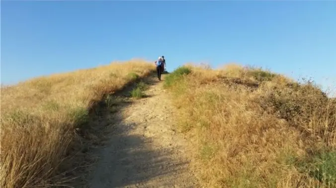
From the Long Canyon trailhead parking lot, we’ll cross the street to the north side, move along the street for about 1/4 mile, then head up the back side for 3/4 mile until we come to a bench. We’ll regroup, then hike along the ridge and back down to the road for about a mile.
We’ll regroup, then cross the road and head along it back towards the parking lot for about 1000′. We’ll turn left to enter into the front side.
We’ll follow a fire road for 1.3 miles until just before it dead ends, where we’ll make a left (not right!) and head 1000′ to the 5-points intersection.
We’ll make a hard right, go another 1000′, and stop at a bench to have a snack share event. After, we continue 3/4 mile down to the parking lot.
Interesting Notes:
Turkey Mullein
Smashed leaves can be thrown into the water to stupefy fish, causing them to float to the surface, a practice illegal in most states. The seeds are not toxic to birds and are enjoyed especially by doves and wild turkeys.
Ancient Greeks rolled and dried the leaves, then used them as wicks for oil lamps. It stalks were used as torches burned at funerals. Many tribes employed the use of mullein leaf tea for coughs, colds, and rheumatism. They considered it to be analgesic, anti-inflammatory, antispasmodic, and expectorant. The astringent and demulcent properties of the leaf tea were found useful in cases of diarrhea.
Wild Oats
The mature seed of the plant is used as a cereal grain. All oats have edible seeds, although they are small and hard to harvest in most species. Oats are hard to tell apart from weedy relatives, so the term “sowing wild oats” came to be used to describe unprofitable activities and destructive sexual liaisons of an unmarried young male that could result in children being born out of wedlock.
Hike
Distance: 4.5 miles
Gain: 1000
Distribution: A couple extended inclines and a couple shorter but steeper inclines.
Difficulty: Easy Intermediate
Shape: Loop, clockwise.
Pace: 2.0 mph.
Trail Type: Fire road, single and double track. Areas of sand, gravel, and rock, some of it rugged.
Trail Variations: The beginning is a flat walk.
The middle will have 2 extended inclines of about 1000 steps and a couple shorter inclines that are steeper but only about 150 steps.
The end is downhill, but somewhat steep.
Duration: 3.5 hours
Dogs: Yes.
Restrooms: No
Drinking Fountains: No.
Parking: Free in the paved parking area in front of the trail head.
What to bring:
1 liter of water for every 3 miles.
Snacks and/or beverages to share
Hiking shoes preferred, athletic shoes will be OK.
Flashlight or headlamp.
Hosting
Route: The host knows the route.
Navigation: Host memory, enhanced by GPS navigation as needed.
Hike type: Social.
The return is a single trail that leads back to the parking lot.
Stops:
The host may designate stopping points to let others catch up. This hike will include an extended stop for a snack and beverage share at the 4/5 point.
We stop at junctions to make sure everybody makes any turns or chooses the correct direction at splits, else something is used to mark the direction, usually a large arrow made of baking soda or sticks.
Directions:
Where of Long Canyon Rd. and S. Wood Ranch Pkwy. intersect in Simi Valley. There is a free paved parking lot at the trailhead on the southwest corner.
From CA-23 and I-101:
North CA-23, exit Olsen Rd.
Right (east) on Olsen Rd., which becomes Madera Rd., for 2 miles.
Right (south) on N. Wood Ranch Pkwy., which becomes S. Wood Ranch Pkwy., for 2 miles.
Right at dead end (intersection with Long Canyon Rd.) and immediate left into parking lot.
Trailhead at the opposite corner.
From CA-118 and CA-27:
West CA-118, exit 23 onto 1st St.
Left (south) on 1st St., which becomes Long Canyon Rd., for 5 miles.
Cross at dead end (intersection with S. Wood Ranch Pkwy.) and immediate left into parking lot.
Trailhead at the opposite corner.
Coordinates of trailhead: 34.228330, -118.803130
A nearby address that should get you to pass by the trailhead: 572 Bannister Way, Simi Valley, CA 93065
FAQ
Hiking Plus Page Links
Disclaimer / Release of Liability


