

## Details
BEFORE YOU WILL BE MOVED TO THE GOING LIST, YOU WILL NEED TO UPDATE YOUR CDH PROFILE (The three questions must be answered with a “yes”) IF YOU HAVE NOT ALREADY DONE SO.
NEED HELP:
go to: [https://wp.me/P9MbG4-hC](https://wp.me/P9MbG4-hC)
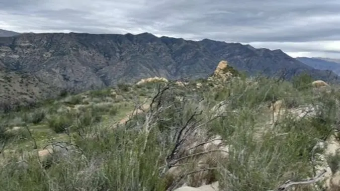
Come and join me on this exploratory within the Santa Ynez mountains. I’ve hiked this trail many times in the past, but it’s been a very long time since I’ve done it and I’ve been dying to see how it has changed over the years. Now is a good time to hike it before the heat. Weather report says it is will be 67 degrees out there in Ojai. The hike will be exposed! So the temperature will be at least ten degrees hotter so I recommend bringing at least 3 liters of water plus plenty of electrolytes. Back in the day I helped cut through this old overgrown forgotten trail along the Kennedy Ridge that reached up a mile over on to the Camino Cielo ridge line. Since then the trail has been cut through four more miles. At the time there were only 4 picnic benches along the way up. Now there are 10! I don’t plan on hiking to all 10 benches, maybe only to the 5th bench. I don’t plan on making this hike too long either, maybe 8 miles or less out and back. This will reach us to Camino Cielo ridge and a little beyond a mile or two. The views are great! and some boulders to climb! We will start the hike at the Oso trailhead in the Ventura River Preserve to the actual trailhead Rice Canyon Rd. to the Kennedy Ridge connection and on our way up a mile or so steep up to Camino Cielo.
My cell # 805-208-3966
MEETUP LOCATION AND TIME: Oso trailhead in the Ventura River Preserve at 8:00 am.
[https://www.google.com/maps/place/34%C2%B027’31.6%22N+119%C2%B017’25.4%22W/@34.458764,-119.2909502,207m/data=!3m2!1e3!4b1!4m6!3m5!1s0x0:0x8a7dded77b87d15c!7e2!8m2!3d34.4587638!4d-119.2904011](https://www.google.com/maps/place/34%C2%B027’31.6%22N+119%C2%B017’25.4%22W/@34.458764,-119.2909502,207m/data=!3m2!1e3!4b1!4m6!3m5!1s0x0:0x8a7dded77b87d15c!7e2!8m2!3d34.4587638!4d-119.2904011)
DISTANCE: 8 miles
ELEVATION GAIN: 2500′


