

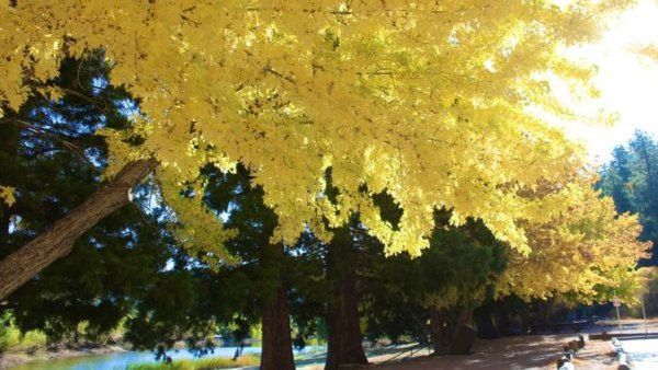
The Jackson Lake Trail is a high-quality single track snaking through the woods on the northern slope of the San Gabriel Mountains. Some of the most beautiful forest in the range can be seen along the trail, including huge ponderosa pine, jeffrey pine, white fir, live oak, black oak, big-leaf maple, alder, and willow. The black oak and big-leaf maple turn brilliant reds and yellows in the fall, providing a photographers’ feast that includes tremendous views across the southwestern Mojave Desert.
West Blue Ridge provides stunning views down the East Fork San Gabriel River and across to 10,064′ Mount Baldy.
Drivers parking at Jackson Lake will need an ADVENTURE PASS.
If you have some place to be later in the day, this event will not work for you.
We will be setting a slow pace with several breaks while staying together all the way so as not to lose anyone.
CHECK OUT THE PHOTOS POSTED FROM THAT HIKE THERE IN 2014:
https://www.meetup.com/calabasasdayhikers/photos/25092192/419820502/
DAY’S AGENDA
START: Once we all arrive at Jackson Lake around 9:00 a.m., we’ll begin our trek along the Jackson Lake Trail to link up with the PCT (Pacific Crest Trail).
PCT: The PACIFIC CREST TRAIL is probably the most well known of all the trails on the west coast. We’ll be hiking a small portion of this trail along THE RIDGE.
THE RIDGE: BLUE RIDGE (around 7500′) offers awesome views into the depths of the east fork of the San Gabriel River and high mountain country as we make our way to THE TRAIL.
THE TRAIL: This is an unnamed trail that drops us down to THE RIFT.
THE RIFT: The RIFT is part of the San Andreas Fault where one can see the tectonic boundary of the right-lateral strike-slip between the Pacific Plate and the North American Plate. It’s here where we’ll then hike along the CEDAR CANYON TRAIL.
CEDAR CANYON TRAIL: This canyon is loaded with Cedar trees and it eventually will take us back to Jackson Lake.
OPTIONAL LATE LUNCH: Mexico Lindo & Seafood Restaurant at 1253 Evergreen Rd, Wrightwood
http://www.mexicolindos.com/
MEETUP LOCATION AND TIME: Jackson Lake parking lot at 9:00 am.
https://www.google.com/maps/place/Jackson+Lake+Picnic+Site/@34.3927461,-117.7317241,796m/data=!3m1!1e3!4m5!3m4!1s0x80c31750467353b3:0x50e8f56da7cba3f!8m2!3d34.3920042!4d-117.7274162
EARLIER MEETUP LOCATION AND TIME: Those out my way can meet me in Woodland Hills at 7:00 a.m. and take off from there in a car pool. Meet at the corner of Leonora Dr. and Ponce Avenue. If meeting here, you must state so in the comments so that I’m aware of it.
AN ADVENTURE PASS IS REQUIRED AT JACKSON LAKE
ROUTE: https://www.alltrails.com/explore/map/map-oct-15-04-08-pm-999600e
DURATION: All day
TERRAIN: Single track trail
DISTANCE: 9.5 miles
ELEVATION GAIN: 2050′
THE PACE: A comfortable pace
LEVEL: Intermediate hiker
MY CELL# IS 805-358-5972


