

Distance: 13 miles round trip; 3,593′ elevation gain/loss
Rating: 8/10, not for beginners.
Elevation starts at 5,100’ at the trail head.
Adventure Parking Pass Required!
Bring plenty of water and electrolyte replacement!
Check the Weather (http://www.wunderground.com/cgi-bin/findweather/hdfForecast?query=91759)
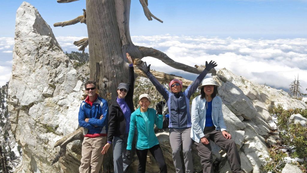
Ontario Peak is the smaller sister of Cucamonga Peak in the Cucamonga Wilderness. Ontario Peak, with its 8,693′ summit, offers spectacular views of the entire area including the inland empire (on a clear day), the San Jacintos, the San Bernardinos, the Santa Ana Mountain range which lies directly south, and the majority of the other major peaks in the area, such as Baldy, the three T’s, Cucamonga, etc… The hike begins in Icehouse Canyon, the hikers’ gateway to the eastern high country and the Cucamonga Wilderness. Its broad, V shaped portal leads east from San Antonio Canyon, 10 miles north of Mt. Baldy Village, and climbs 2600′ to Icehouse Saddle, a prominent gap on the great Telegraph Ontario Ridge. The saddle is a major trail junction, with routes leading in four directions. From the saddle we’ll follow the trail up past Kelly’s Camp, climbing a further 500′ to the summit to enjoy the view and lunch. As always know your limits, bring ample quantities of water, a hat and sunscreen, good hiking shoes. Walking sticks would be helpful in certain areas.
The Norman Ollestad Story
On February 19, 1979, 11-year-old Norman Ollestad was traveling from Santa Monica airport into Big Bear to retrieve a skiing trophy he had won the day before. Along for the ride were his father, his father’s girlfriend, Sandra, and the pilot of the small, chartered Cessna.
About fifteen minutes into the flight, they were caught up in a blizzard and the plane crashed into Ontario Peak mountain and Norman’s father and the pilot were instantly killed. Norman and Sandra survived, but she had a broken arm and a severe head injury. Cut off from radar, and in the middle of a near white-out, little Norman had to lead them down to safety with Sandra, sometimes, literally on his back. The dangerous trek down the steep mountain lasted 9 hours, and when it was over, Sandra too, was dead. Frostbitten and barely able to walk, Norman was the only survivor of the tragedy.
Norman wrote of his experience in Crazy for the Storm (http://www.crazyforthestorm.com/index.php).
Directions: Check your local map to plan a route to the 210 freeway traveling east from Pasadena past the 57 freeway. As you enter the town of Upland, exit at Base Line, turn left on Base Line and take the first right on Padua Ave. Make a right on Mt. Baldy Road into the mountains towards Baldy Village. A couple miles after Baldy Village you will enter the parking lot for Ice House Canyon. Make sure you do not keep going up to the Manker Flats area. Park your car in the parking lot making sure to display your pass in the windshield.
*******************************************************************
PLEASE – Know your limits and abilities. Bring snacks and drink plenty of liquids when hiking. Check weather conditions and dress accordingly and be aware of your surroundings at all times. Watching out for poison oak, snakes, ticks, uneven footing, spectacular views, beautiful fauna all while interacting with awesome (usually) fellow hikers can be extremely hazardous, rewarding and fun.
VHC HIKE RATING SCALE
Rating a hike is subjective, meaning the difficulty of a hike will be in direct relation to how often you hike and the type of hike you prefer. Keep in mind that any hike can have the following: un-even hiking surfaces, various obstructions, water and/or water crossings or bouldering and/or rock hopping. A great hike will have all of these!
1 – A long walk
2 – 4 mile hike w/little elevation gain
3 – 5 mile hike w/up to1000 ft. elevation gain
4 – 5+ mile hike w/up to1500 ft. elevation gain (heart rate increases at times)
5 – 7+ mile hike w/over 1500 ft. elevation gain (heart rate increasing even more at times)
6 – 7+ mile hike w/over 2000 ft. elevation gain (at times you might be trying to remember how to perform CPR)
7 – 5+ mile hike w/over 2000 ft. elevation gain (at times you might be muttering expletives to yourself)
8 – 10+ mile hike w/over 3500 ft. elevation gain (at times you might be angry with the hike leader)
9 – 10+ mile hike w/over 5000 ft. elevation gain (at times you might be thinking of reporting the hike leader to the authorities)
10 – Use your imagination
Class 3 Scrambling: Scrambling or un-roped climbing. You must use your hands at times to hold the terrain or find your route. This may be caused by a combination of boulders, steepness and extreme terrain. Some Class 3 routes have ropes in place for assistance.
DISCLAIMER / RELEASE OF LIABILITY
IMPORTANT, PLEASE READ BELOW IN ITS ENTIRETY:
I am a volunteer (i.e. not liable for the group). Safety is a priority for everyone in the group. Think of this as hiking with a group of friends.
Outdoor sports and other events we plan can be inherently dangerous and accidents may happen. By participating in any posted event, you’re taking responsibility for your own safety and well-being. The Valencia Hiking Crew Meetup Group and its organizers are not trained leaders and we do not confirm the qualifications of any of its members to lead or participate in trips. All participants take full responsibility for their own actions. If you choose to sign up for any Valencia Hiking Crew Meetup events, you are releasing the Valencia Hiking Crew Meetup Group and it’s organizers from all liability in case of possible injuries as stated in paragraph 6.2 of the Meetup “Terms of Service” located on the bottom of the Meetup website. Your personal safety depends on your own judgment and experience.


