

5.3 miles, 600′ gain, Easy-Intermediate
2 miles, 100′ gain, Beginner
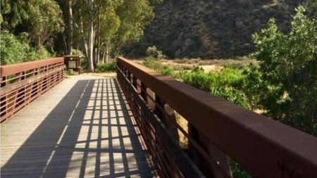
We start by crossing a bridge into a wooded area and continue down a relatively flat path alongside a stream. After about a mile, we’ll come to a junction.
For those that want the full hike, we’ll turn right and complete a 3 mile loop with 500′ of gain, stopping just before the end of the loop for a social event at the picnic table on the left.
The social event that will last 60 minutes, sharing snacks and beverages (https://www.meetup.com/Hiking-Plus/messages/boards/thread/50879772).
For those that want to keep it beginner, pass the junction and continue for 1/4 mile and no gain. That same picnic table will be on the right.
For the return, we continue the loop for 1/4 mile, then a relatively flat walk back for about a mile.
Hike Distance: 5.3 miles
Gain: 600′
Distribution: Most of the incline is concentrated in the second quarter.
Difficulty (https://www.meetup.com/Hiking-Plus/messages/boards/thread/50879781): Easy Intermediate.
Shape: Lollipop.
Pace: approx. 2.0 mph.
Trail Type: Fire road.
Trail Variations: The first mile is flat.
All of the trail is well groomed and not rugged.
Duration: 3.5 hours
Dogs: Yes.
Restrooms: Yes, at trailhead
Drinking Fountains: No.
Parking: Free in lot next to trail head.
What to bring:
1 liter of water for every 3 miles.
Hiking shoes/boots. Not required, but recommended.
Flashlight or headlamp.
Sunscreen and/or hat as needed.
Snacks and/or beverages to share (https://www.meetup.com/Hiking-Plus/messages/boards/thread/50879772).
Hosting
Route: The host knows the route. The route is posted as a photo with this description.
Navigation: Host memory, enhanced by GPS navigation as needed.
Hike type: Social.
We won’t be hiking at a fast pace because this is a social hike, not a conditioning hike. There is nothing wrong with stopping, even if it means every 50 steps.
Interesting Notes
Here are a couple plants you are sure to see on this hike:
Wild Oats
The mature seed of the plant is used as a cereal grain. All oats have edible seeds, although they are small and hard to harvest in most species. Oats are hard to tell apart from weedy relatives, so the term “sowing wild oats” came to be used to describe unprofitable activities and destructive sexual liaisons of an unmarried young male that could result in children being born out of wedlock.
Red Brome
Grass like with thorny appearing tops. A sub-species of foxtail chess. Can lead to flash fires. Winter fires don’t kill the seeds.
Directions:
Hill Canyon Trailhead
10241 Hill Canyon Road (address is before trailhead, continue to gravel lot on left)
Santa Rosa Valley, CA 93012
Coordinates of trailhead: 34.226495, -118.930374
From CA-118:
CA-118 west to CA-23 south.
Exit 19 Tierra Rejada Rd., turn right (west) for 0.5 miles
Left (south) on Moorpark Rd. for 1.4 miles.
Right on Santa Rosa Rd. for 3.7 miles.
Left on Hill Canyon Rd. for 0.6 miles.
Parking in gravel lot on left.
From CA-101 (from Camarillo and farther west):
Exit Santa Rosa Rd. north for 4.9 miles.
Turn right (south) on Hill Canyon Rd. for 0.6 miles.
Parking in gravel lot on left.
From CA-23 and CA-101 (from Thousand Oaks):
North on CA-12 for 3.1 miles.
Exit 16 Sunset Hills Blvd. and left (west) for 0.9 miles.
Left (west) on E. Olsen Rd. for 0.8 miles.
Right (north) on N. Moorpark Rd. for 1.9 miles.
Continue on Santa Rosa Rd. west for 3.7 miles.
Turn left (south) on Hill Canyon Rd. for 0.6 miles.
Parking in gravel lot on left.
Disclaimer / Release of Liability:
https://www.meetup.com/Hiking-Plus/pages/29622459/Is_Hiking_Dangerous/


