

It’s another beach party! 2.7 miles, 650′ gain.
Note: GPS has taken people to the incorrect location. Please read the written directions.
A hike, then a potluck party on the beach with a fire. Come for the hike, the beach party, or both!
Please post in the comments if you will bring a fire wood bundle as your pot luck item.
Firewood:
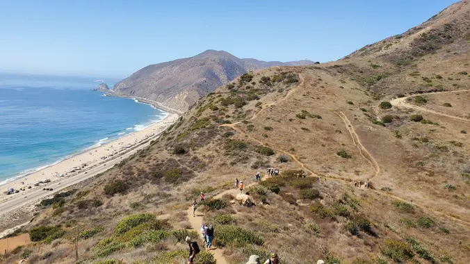
The Hike. 2 – 3:30p.
Easy-Intermediate. Beginners are welcome, but if it gets too hard, they can always turn around and go back the way we came. Nearly all of the elevation gain is in the first half.
This is a social hike. We’ll move slowly and stop at various points to let people catch up. Those that wish to move ahead at a faster pace, are on their own regarding route and navigation.
From the trailhead, we walk a mostly flat trail about a 1/2 mile. Left onto the Overlook Trail, climbing 400′ over the next mile. It ends, and we turn left. We follow the ridge for about 1/2 mile, with about 200′ of loss and 100′ of gain.
For return, we follow our tracks back to the scenic trail, turn right, and follow it down for about 3/4 mile, again reaching Big Sycamore Canyon Trail fire road, and turning right back to our starting point.
The Beach Party. 4:00 – 9:00p.
If you need to, go back to your car and gather up things for the beach party. From the trail head, it’s about 1/4 mile to the camp ground parking lot, then another 1/4 mile to the beach party area across the road at Sycamore Cove Beach. There are picnic tables and fire pits, but we must supply our own wood to burn.
If your pot luck item requires utensils, please bring them.
The fire pits on the beach are first come, first serve. We have members that have volunteered to arrive early in the morning to secure a fire pit and tables.
Please bring something warm to put on. It can get cool and windy near the beach, especially as the sun drops. A chair and blanket recommended.
Going in the Water
Where the waves break, it is gravel. Water shoes are recommended.
Showers are available to rinse, but no place to sit and change.
I bring a gallon of water so I can find a place to sit and rinse my feet.
Sunset: 5:59p.
Prior beach events:
7/2022
10/2021
9/2019
6/2018
4/2018
Hike
Distance: 2.7 miles
Gain: 650
Distribution: All the incline is in the first half.
Difficulty: Beginner end of intermediate spectrum.
Shape: Counter-Clockwise upside-down lollipop
Pace: approx. 2.0 mph.
Trail Type: Fire road, double track, and single track.
Duration: 1.5 hours (hike), 4 hours (beach party)
Dogs: No.
Restrooms: Yes
Drinking Fountains: Yes.
Parking
Prices from 10/30/2021: Campground lot, $14, gates close at 10p. Beach lot $12, $11 62+ (you need your license plate #, pay “Iron Ranger” machine upon entry with a credit card).
Alternate parking.
Along the west end of PCH, but you may have to walk 1/4 mile or more.
I recommend you pull up past the gate, pull over, drop stuff off, do it quick. By pulling up well past the entrance, you avoid any interaction with the guards at the entrance.
Parking space is limited, so please car-pool or arrive early in case you have parking issues. The beach lot closes at sunset and rangers announce this to beach goers, giving plenty of time to move your cars. What you paid for the beach lot also covers the campground lot parking cost, across the street.
What to bring: 1 liter of water for every 3 miles.
Hiking shoes/boots. Not required, but recommended.
Sunscreen and/or hat as needed.
Food and drink to share for the beach pot luck.
Route Link
Navigation: Host memory and GPS navigation as needed.
Hike type: Social.
We won’t be hiking at a fast pace because this is a social hike.
Directions
Sycamore Canyon Trailhead
Malibu, CA 90265
Coordinates of trailhead: 34.074747, -119.014081
Hike is inside Sycamore Canyon Campground, Beach party is across the street
From CA-118
CA-118 West.
CA-23 South for 7.4 miles.
US-101 North for 10.8 miles.
Exit 53B Lewis Rd./CA-34.
Right (east) onto E. Daily Dr. for 0.1 miles.
Right (south) onto N. Lewis Rd. for 4.5 miles.
Becomes Hueneme Rd., continue for 0.9 miles.
Left on Las Posas Rd. for 3.1 miles.
Left on CA-1 for 5.9 miles.
Park in campground lot (left), beach lot (right), or on street west of lots.
From US-101
Exit 55, Las Posas Rd.
Las Posas Rd. south for 7.5 miles.
Left on CA-1 for 5.9 miles.
Park in campground lot (left), beach lot (right), or on street west of lots.


