

5.7 Miles, 1000′ gain, Intermediate
The starting point is NOT at the golf course entrance. It is at a dirt lot that can hold at least 50 cars. There is some real incline on this hike and a lot less trails coated with silt compared to the easier Happy Camp hike.
Even though I have rated this “intermediate”, there are no steep sections. The 2nd quarter is an continuous fire road incline that can get exhausting.
We start with about 1.25 miles of relatively flat and slightly downhill double-tracker. Then we start up a fire road for 1.5 miles with a continuous incline of 700′. This section can be exhausting, so I’ve rated the hike on the easy end of the Intermediate spectrum.
A strong and motivated beginner can do this hike, but they will be challenged and slow during this segment. That’s OK, because this is not a conditioning hike, it is a social hike. We’ll be stopping at various points to regroup, and there is nothing wrong with taking many small stops along this section to catch your breath.
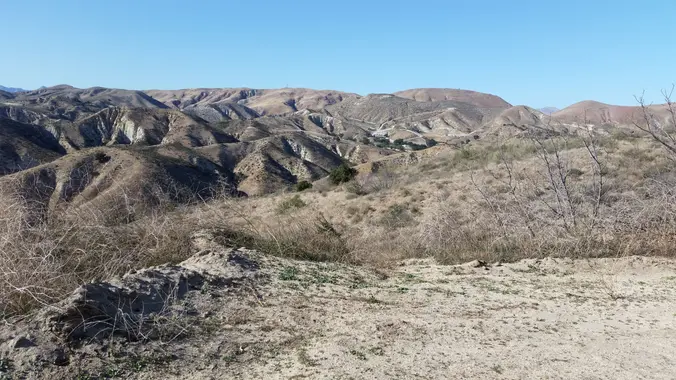
After having done two segments, we’ll reach a steel hitching post and clearing, where we’ll have a social event lasting about an hour. We’ll be rewarded with spectacular views in all directions. During the day, you can easily see the ocean and Channel Islands. Finally, we’ll head back the way we came.
Interesting Notes
These are plants you will likely see on this hike.
White Sage
It is very aromatic and is the plant burned in “smudging” to ward off evil spirits and perform other purification.
Along the second half of the outbound section, both sides of the trail have patches of White Sage.
Black Mustard
Flowers, leaves (mustard greens), and roots are edible. Can be used as a spice. Grind seeds and mix with water and vinegar to make prepared mustard.
Directions
Happy Camp Rustic Canyon
13650 Broadway Rd.
Moorpark, CA 93021
Coordinates of trailhead: 34.315212, -118.874620
From CA-118:
West on CA-118, exit 19a Princeton Ave.
Left on Princeton for 1.4 mile until dead end.
Right on Spring Rd. for 1.3 miles.
Right on CA-23N/Walnut Canyon Rd. for 0.9 miles.
Becomes Happy Camp Rd. for 236′.
Right on Broadway Rd. for 0.3 miles.
Parking lot in Northeast corner of intersection.
From CA-23 and US-101:
North on CA-23.
CA-118 east for 0.6 miles.
Exit 19a, Princeton Ave.
Right on Princeton for 1.4 mile until dead end.
Right on Spring Rd. for 1.3 miles.
Right on CA-23N/Walnut Canyon Rd. for 0.9 miles.
Becomes Happy Camp Rd. for 236′.
Right on Broadway Rd. for 0.3 miles.
Parking lot in Northeast corner of intersection.
The Hike
Distance: 5.7 miles, 3.75 hours
Elevation Gain: 1000′
Difficulty: Intermediate.
Pace: 2.0 mph
Dogs: No
Restrooms: Yes.
Drinking Fountains: No.
Parking: Free in the dirt lot at the trailhead
Trail: Double Track and Fire Road, with some sand.
Hosting
Route: The host knows the route.
Navigation: Host memory, enhanced by GPS navigation as needed.
Hike type: Social.
This description includes a picture of the route. Those that wish to return immediately instead of hanging around during the snack and beverage share, should memorize the below route so they can safely return on their own.
Stops:
The host may designate stopping points to let others catch up. This hike will include an extended stop for a snack and beverage share at the half way point.
Group separation:
Sometimes hikers wish to move significantly ahead and not wait at designated stopping points. Please let the host know. They are on their own regarding route and navigation.
What to Bring
1-2 liters of water.
Snacks and/or beverages to share
Hiking shoes preferred, but athletic shoes will be OK.
Flashlight or headlamp.
Sunscreen and/or hat as needed.
FAQ
Hiking Plus Page Links
Disclaimer / Release of Liability


