

DESCRIPTION:
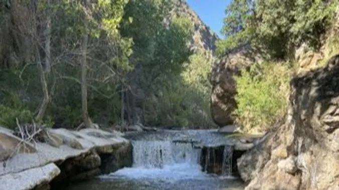
Excellent write up of this hike at Hikespeak “Fish Canyon Narrows in the Sierra Polona Mountains” by Seth Snigelske. This is a beautiful area. Bring your camera. Not only is the area beautiful, but you might see some of the endangered species along the way. Please stay on the trails here and watch where you step during the stream crossings. The hike starts on an abandoned asphalt road, moves onto a dirt road at the north end of Castaic Lake and follows Fish Canyon. At the old Cienaga campground we split off the main trail for the trail to Piano Box Canyon, a beautiful single track wooded trail. After Piano Box we will enter the narrows with red/orange cliffs. Our next 1.5 miles will be following a creek bed with 100′ cliffs on both sides. This section of the hike reminds me of Zion National Park. We will take a 15 minute snack and rest stop at the old Roger Camp before heading back to our cars. Be sure to enjoy and take pictures during our hike in the narrows.
DETAILS:
· Hike leader volunteer(s): Dave.
· Meet: 37773 Templin Highway at 7:30 am, departure at 7:45 am sharp (December 14).
· Distance: ~ 11.5 Miles total (out and back style)
· Elevation gain: ~ 1050′
· Time: Approximately 7 hours hiking including a 15 minute snack break.
· Conditioning: You need to be in generally good physical condition.
· Dogs: Should skip this hike.
· Hiking Poles – recommended (for water crossings) I wouldn’t hike the section between piano box and Rodger Camp without hiking poles.
· Restrooms – None.
· Adventure Pass – None Required.
Hike leader Notes: Pre-hiked this trail on 11/27/24. The fall colors are great with plenty of water. As we near the end of the year I like to toss our a tough hike. The section between the start and Piano Box is a 4 but the section between Piano Box and Roger Camp will wear you out. I have hiked this section 5 times and it wears me out each time. There is bear scat and Mt Lion tracks on this trail so lets stay together. Lots of poison oak (red this time of year). I will include photos from 11/27 hike.
IMPORTANT NOTES: We’ll hike at a brisk pace and ask everyone to stay with the group for a friendly and safe outing. Any guest that you wish to invite should join the Community Hiking Club (CHC) to participate. Depending on water flow, we may cross streams, but there aren’t exposures, bugs or other warnings. As always, people may slip and fall, encounter poison oak, snakes, etc. on this hike. This event may be cancelled due to inclement weather at the start of the hike.
ESSENTIAL GEAR:
Hiking boots and poles.
Clothing layers recommended.
Snacks and 2+ liters of water and electrolytes or salt tablets.
Hat and sunscreen.
Additional Hiking and Survival Gear Recommendations (link)
THIS HIKE RANKING: Level 3/4, Intermediate (see chart below) – mainly for the 3 mile section without trail in the narrows.
CHC HIKE RANKING SCALE:
1. Beginner: 1-3 miles, less than 500 feet elevation gain.
2. Beginner/Intermediate: 1-7 miles, less than 700 feet elevation gain.
3. Intermediate: 5-10 miles, 1000-2000 feet elevation gain.
4. Intermediate/Advanced: 7-12 miles, up to 3000 feet elevation gain.
5. Advanced: 10-17 miles, 3000 feet or more elevation gain.
TRAILHEAD LOCATION:
37773 Templin Highway, Angeles National Forest, Castaic, CA 91384
FILE DOWNLOADS
We highly recommend the AllTrails app be installed on your cell phones and/or you print a copy of the trail map so you can personally navigate the trail if you need to.
GPS Trail Map (link for downloadable mobile version)
DISCLAIMER / RELEASE OF LIABILITY – IMPORTANT, PLEASE READ BELOW IN ITS ENTIRETY:
When you sign up for this event, you are releasing Community Hiking Club from any liability or responsibility with your participation in this group activity. While safety is a priority for everyone in the group, hiking can be inherently risky. By participating in any posted event, you are assuming responsibility for your own safety and well-being. The Community Hiking Club (CHC) Meetup Group and its organizers and hike leaders are not trained leaders and we do not confirm the qualifications of any of its members to lead or participate in our events. All participants take full responsibility for their own actions. If you choose to sign up for any Community Hiking Club Meetup events, you are releasing the Community Hiking Club Meetup Group and Hike Leaders from all liability in case of possible injuries or death as stated in paragraph 6.2 of the Meetup “Terms of Service” located on the bottom of the Meetup website. Your personal safety depends on your own judgment and experience. If you sign up for this hike, you are verifying that this hike is within your abilities.
The Community Hiking Club is a Non-Profit 501C3 organization. We rely on donations to continue sponsoring hikes like this. Please contribute by donating via: Cash contribution (at each hike), or via Zelle at 6617135610; or via Venmo at: @Heidi-Webber-5


