

The Stats
Distance: 7> a guess
Rating: 7 a guess
Elevation gain: a guess)
Trail: Looped single track
Pace: Not for beginners -will be at my pace
The Plan
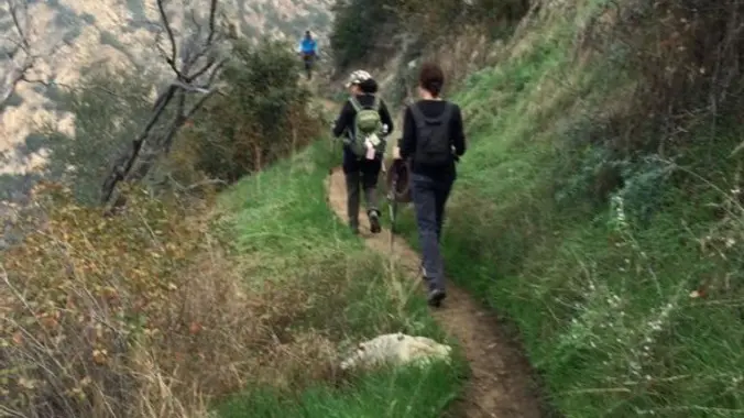
Our route starts at Chaney Trail trailhead and follows the fire road and Sunset Ridge Trail up to Dawn Station, then descends to the mine, after a break we will follow the canyon out -this is a loop
Dawn Mine has been closed 🙁 – (the actual mine)
The Story
Over its 50-plus years, Dawn Mine produced more stories than gold. Enough gold was recovered to keep various over-optimistic operators looking for the bonanza that never came. Some unknown prospectors discovered gold in Millard Canyon in 1895 and small claims were staked and worked for 7 years with marginal results. Minor Bradford Peck named the mine for Dawn Ehrenfeld, little daughter of a friend from the Randsburg Mines. Michael Ryan bought the Dawn Mine in 1902. He bore tunnels into the canyon’s rock walls and was successful for several years. He built a narrow trail up the steep slope to the Mt. Lowe Railway. Two mules, Jack and Jill, carried the ore to Dawn Station to be transferred to railcars and taken down to the valley for milling. After Ryan’s death in 1929, the mines set idle for several years. In 1933 Ryan’s widow leased the holdings to Hunger, Comstock, and Hilton, who bored a new, 1,200-foot tunnel and built a small mill. They had good success at first, but in spite of considerable more digging, the gold petered out. In a few more years the venture was closed down. In the 1940s and early 1950s, other miners gave it a try but with no positive results.
https://secure.meetupstatic.com/photos/event/1/2/a/600_462060298.jpeg
Directions: Exit the 210 fwy in Pasadena at Fair Oaks and go north to Loma Alta Dr. Turn left here and then turn right on Chaney Trail (flashing yellow light overhead). Take Chaney Trail to the top, you’ll see a gate to your right. continuing down the road past where the gate is will take you down to parking for Millard Campground, we are not meeting down there.
The gate to Chaney opens at 6 am so be here on time, the parking spaces at Chaney is very limited.
Check the Weather (http://www.wunderground.com/q/zmw:91001.1.99999)
***
The Fine Print
PLEASE – Know your limits and abilities. Bring snacks and drink plenty of liquids when hiking. Check weather conditions and dress accordingly and be aware of your surroundings at all times. Watching out for poison oak, snakes, ticks, uneven footing, spectacular views, beautiful fauna all while interacting with awesome (usually) fellow hikers can be extremely hazardous, rewarding and fun.
The Farzan Rule: Posted hike times are the time the hike starts or we leave from a posted shuttle location. I’m aware other Meetup groups offer a grace period for late arrivals; we don’t. It’s your responsibility to know the location of the meeting spot and be there and ready to participate at the posted time. If you have any concerns about the directions feel free to contact the organizer of the event, preferably in advance of the event and not at the start time. I’m of the opinion that it’s not fair to delay an event when the majority of attendees have arrived on-time. (so named after a conversation I had with a certain un-named member)
RSVP’s: If you RSVP for an event be responsible and update your RSVP if your plans change. If your plans change at the last second and you’re not able to update your RSVP also let us know. In my opinion a no-show is someone who has no regard for following the guidelines we request from our members and will risk being removed from future events that have a limit.
VHC HIKE RATING SCALE
Rating a hike is subjective, meaning the difficulty of a hike will be in direct relation to how often you hike and the type of hike you prefer. Keep in mind that any hike can have the following: un-even hiking surfaces, various obstructions, water and/or water crossings or bouldering and/or rock hopping. A great hike will have all of these!
1 – A long walk
2 – 4 mile hike w/little elevation gain
3 – 5 mile hike w/up to1000 ft. elevation gain
4 – 5+ mile hike w/up to1500 ft. elevation gain (heart rate increases at times)
5 – 7+ mile hike w/over 1500 ft. elevation gain (heart rate increasing even more at times)
6 – 7+ mile hike w/over 2000 ft. elevation gain (at times you might be trying to remember how to perform CPR)
7 – 5+ mile hike w/over 2000 ft. elevation gain (at times you might be muttering expletives to yourself)
8 – 10+ mile hike w/over 3500 ft. elevation gain (at times you might be angry with the hike leader)
9 – 10+ mile hike w/over 5000 ft. elevation gain (at times you might be thinking of reporting the hike leader to the authorities)
10 – Use your imagination
Class 3 Scrambling: Scrambling or un-roped climbing. You must use your hands at times to hold the terrain or find your route. This may be caused by a combination of boulders, steepness and extreme terrain. Some Class 3 routes have ropes in place for assistance.
DISCLAIMER / RELEASE OF LIABILITY
IMPORTANT, PLEASE READ BELOW IN ITS ENTIRETY:
I am a volunteer (i.e. not liable for the group). Safety is a priority for everyone in the group. Think of this as hiking with a group of friends.
Outdoor sports and other events we plan can be inherently dangerous and accidents may happen. By participating in any posted event, you’re taking responsibility for your own safety and well-being. The Valencia Hiking Crew Meetup Group and its organizers are not trained leaders and we do not confirm the qualifications of any of its members to lead or participate in trips. All participants take full responsibility for their own actions. If you choose to sign up for any Valencia Hiking Crew Meetup events, you are releasing the Valencia Hiking Crew Meetup Group and it’s organizers from all liability in case of possible injuries as stated in paragraph 6.2 of the Meetup “Terms of Service” located on the bottom of the Meetup website. Your personal safety depends on your own judgment and experience.


