

BEFORE YOU WILL BE MOVED TO THE GOING LIST, YOU WILL NEED TO UPDATE YOUR CDH PROFILE (The three questions must be answered with a “yes”) IF YOU HAVE NOT ALREADY DONE SO.
NEED HELP:
[[go to: https://wp.me/P9MbG4-hC](go to: https://wp.me/P9MbG4-hC)](http://%5Bgo%20to:%20https//wp.me/P9MbG4-hC%5D(go%20to:%20https://wp.me/P9MbG4-hC))
WATERMAN’S BACKBONE VIA A CAR SHUTTLE
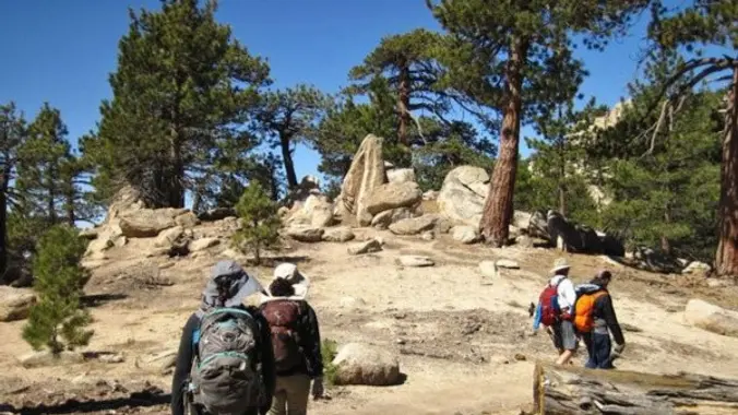
This event will allow us to trek along Waterman Mountain’s ridgeline as we start our adventure at Cloudburst Summit (PCT junction) and head up a very steep “use trail” to Waterman Mountain. From there it will be mostly downhill as we follow Waterman’s trail less backbone to Three Points (another PCT junction). Along the way we should be seeing lots of wild flowers along with spectacular views as well as lots of rock outcroppings to check out.
EARLIER MEETUP LOCATION AND TIME: 6:30am at the Woodland Hills Meetup location. Those who want to carpool from Woodland Hills, can meet me at the corner of Leonora and Ponce Avenue. Ponce is the first street east of Fallbrook. We can park on Ponce which is not in front of any houses.
IF MEETING HERE, LET ME KNOW, OTHERWISE I WON’T BE STOPPING THERE.
SEE MAP SITE BELOW
[https://www.google.com/maps/place/34%C2%B010’04.0%22N+118%C2%B037’16.0%22W/@34.1677751,-118.6216512,228m/data=!3m2!1e3!4b1!4m6!3m5!1s0x0:0x0!7e2!8m2!3d34.1677741!4d-118.6211043](https://www.google.com/maps/place/34%C2%B010’04.0%22N+118%C2%B037’16.0%22W/@34.1677751,-118.6216512,228m/data=!3m2!1e3!4b1!4m6!3m5!1s0x0:0x0!7e2!8m2!3d34.1677741!4d-118.6211043)
MEETUP LOCATION AND TIME: 7:30 am at the meetup location on Hwy. 2 in La Canada. (BOOTS ON, READY TO GO).
IF MEETING THE GROUP HERE, YOU MUST STATE SO, OTHERWISE I WON’T BE STOPPING HERE.
MEETUP DIRECTIONS: From the 210 Fwy, exit at Angeles Crest Hwy and drive north about a quarter mile to just past Milmada Dr. in LA CANADA, then park alongside the road. We will all meet here no later than 7:30 a.m. and take as few cars as possible to Three Points Summit.
[https://www.google.com/maps/place/Three+Points+Trailhead/@34.3398586,-117.9997747,14z/data=!4m5!3m4!1s0x80c2e3a2211068bf:0xb78ddf64f081d3fc!8m2!3d34.343403!4d-117.9827788](https://www.google.com/maps/place/Three+Points+Trailhead/@34.3398586,-117.9997747,14z/data=!4m5!3m4!1s0x80c2e3a2211068bf:0xb78ddf64f081d3fc!8m2!3d34.343403!4d-117.9827788)
EXPERIENCE LEVEL: Strong intermediate hikers on up
DISTANCE: 6 miles
ELEVATION GAIN/LOSS: 1200’/2200′
TRAIL DESCRIPTION: Mostly “use trails” with some single track trails
THE PACE: Slow pace
ROUTE: [https://www.alltrails.com/explore/map/bit-of-pct-silver-mocasin-trails-da4f21d](https://www.alltrails.com/explore/map/bit-of-pct-silver-mocasin-trails-da4f21d)
DURATION: We’ll want to finish the hike and be back to the cars by 3:00 p.m. at the latest, followed by lunch at The Habit Burger Grill in La Canada.
MY CELL #: 805-358-5972


