

BEFORE YOU WILL BE MOVED TO THE GOING LIST, YOU WILL NEED TO UPDATE YOUR CDH PROFILE (The three questions must be answered with a “yes”) IF YOU HAVE NOT ALREADY DONE SO.
NEED HELP:
[go to: https://wp.me/P9MbG4-hC](go to: https:/
THE QUEST: My pursuit of taking on Mount Baden Powell the hard way, via The Big Horn Mine on my 75th birthday, continues as I get my self in shape by taking on Mount Burnham, Throop Peak and Mount Hawkins this week.
Join me and experience the thrill of hiking in the high country of the San Gabriel Mountains. We’ll be taking on Mount Burnham, Throop Peak and Mount Hawkins via Dawson Saddle and finishing at Windy Gap. This trek is only 7.5 miles with a 2200′ overall gain consisting mostly of the PCT (Pacific Crest Trail). This will be accomplished by way of a car shuttle.
This all day trek is for those of you who are looking for something a lot more challenging than the average outing. No beginners please unless you’re in top physical condition. If you have some place to be later in the day, this event will not work for you.
We will be setting a steady pace with several breaks while staying together all the way so as not to lose anyone.
MICRO SPIKES AND POLES ARE RECOMMENDED
DAY’S AGENDA
START: After dropping a car/s off at The Windy Gap Trailhead we’ll drive to the Dawson trailhead where the trek begins to Mount Burnham.
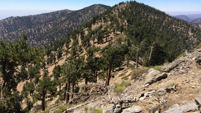
MOUNT BURNHAM: Standing at 8900′, Mount Burnham is one of the highest peaks in the San Gabriel Mountains. It is in the Sheep Mountain Wilderness. It is named for Frederick Russell Burnham the famous American military scout who taught Scoutcraft to Robert Baden-Powell and became one of the inspirations for the founding of the Boy Scouts. From there we’ll double back towards Windy Gap, picking up Throop Peak.
THROOP PEAK: Standing at 9118′, Throop Peak was named for Amos G. Throop founder of Caltech formerly called Throop College. The peak marks the northwestern boundary of the Sheep Mountain Wilderness. Having bagged two peaks, we’ll then take on a third, Mount Hawkins.
MOUNT HAWKINS: Standing at 8783′, Mount Hawkins will be our final peak to conquer before heading down to Windy Gap.
WINDY GAP: From this vantage point one faces into a seemingly perpetual wind that blows up from the broad canyon below. The benchmark here is posted at 7,588′
MEETUP LOCATION AND TIME: 6:30 am at the meetup location on Hwy. 2 in La Canada. (BOOTS ON, READY TO GO).
IF MEETING THE GROUP THERE, YOU MUST STATE SO, OTHERWISE I WON’T BE STOPPING THERE.
MEETUP DIRECTIONS: From the 210 Fwy, exit at Angeles Crest Hwy and drive north about a quarter mile to just past Milmada Dr. in LA CANADA, then park alongside the road.
https://www.google.com/maps/place/34%C2%B012’31.7%22N+118%C2%B011’59.8%22W/@34.2088224,-118.2021197,17z/data=!3m1!4b1!4m6!3m5!1s0x0:0x3a7e81cac75a935a!7e2!8m2!3d34.2088179!4d-118.1999312
EARLIER MEETUP LOCATION AND TIME: 5:45am at the Woodland Hills Meetup location.
IF MEETING THERE, LET ME KNOW, OTHERWISE I WON’T BE STOPPING THERE.
https://www.google.com/maps/place/34%C2%B010’04.0%22N+118%C2%B037’16.0%22W/@34.1677751,-118.6216512,228m/data=!3m2!1e3!4b1!4m6!3m5!1s0x0:0x0!7e2!8m2!3d34.1677741!4d-118.6211043
DURATION: We’ll want to finish the hike and be back to the cars by 3:30 p.m. at the latest, followed by lunch at The Habit Burger Grill/ Pandera Bread in La Canada.
TERRAIN: Popular trails as well as an extremely dropping down from Windy Gap to Hwy. 2.
DISTANCE: 7.5 miles
ELEVATION RANGE: Gain of 2200′ and a loss of 2800′
THE PACE: A comfortable pace no faster than the slowest hiker.
LEVEL: Advanced Intermediate
MY CELL NUMBER IS: 805-538-5972
DOGS ALLOWED: NO


