


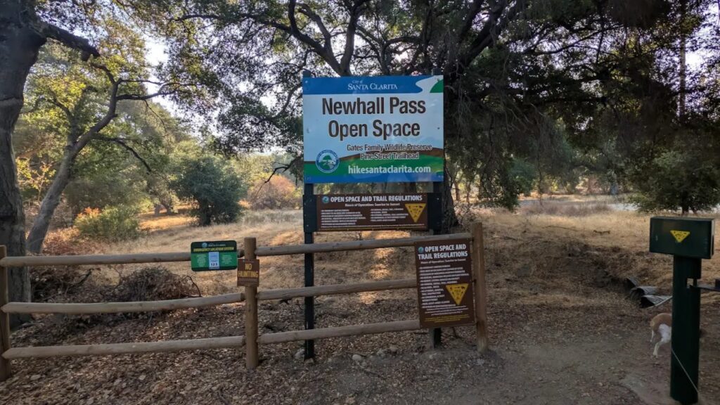
Where: Gates Wildlife Preserve/Newhall Open Space – Newhall CA
Saturday is expected to be hot, so get out and move for a few hours on a newly discovered trail called “Twister” that I doubt any of you have hiked. Also, its close – in Newhall – just south of Newhall Avenue and Railroad Ave. Get there in a few minutes, and hike for a few hours, and be done by 10 am before it ever gets hot.
We’ll start early – at 7 am, and be done by 10:00 am.
The trail starts out as a dirt road with minor elevation increase, but then we start heading up a hill climb to the top. Its 1290 feet of climb, then back down the way we came. If we keep a good pace, that leaves us time for one of two other loop trails that will add another 2 miles or so. Because of the impending heat, we’re going to play it by ear and see how you’re feeling about adding a bit more.
This trail is not hard, but its mostly all uphill, but in the shade and should be pleasant enough. I’m ranking it a low 3 because we’ll be moving fast, and covering about 3-5 miles in a few hours. Come enjoy the quite local area, with views of hillsides with large oak trees and a view along the way.
Bring a minimum of 2-3 liters of water, electrolytes, hats and sun screen are recommended.
Be aware that we’ll be hiking in an Extreme Heat Watch October 2, 10:00 am until October 8, 08:00 pm – where high temperatures are forecast to be about 99 degrees. We will be watching the temperature, and will call it a day if it starts hitting the low 90’s earlier than I think – but by 10 am when we finish, it should still only be 87 degrees.
We will take a quick water break once or twice, but no snack time or longer break is planned. We’ll hike at a moderately brisk pace suitable for conditioned intermediate hikers. If you have any medical issues or concerns, or don’t do well with heat and steep climbs, think twice before signing up please.
Stats:
Minimum 3.1 miles (unless we decide to explore another 2 mile loop)
Elevation: 1290 feet minimum.
Starting temperature at 7:00 am: 71 degrees
Ending temperature at 10:00 am: 87 degrees*
Note: by Noon, the temperature is expected to be 99 degrees
Its nearby:
Its located at the very southern end of Pine Street, just off Newhall Avenue (just east of Railroad’s intersection with Newhall Avenue), so it’s easy to get to. Go south on Pine. The asphalt will turn to dirt. Keep going ALL THE WAY until you see us, and a sign and gate at the Gates Preserve (part of the Newhall Open Space area). You can’t miss it.
Hike organizer(s): Gary S
Recommended for: Level 3 Hikers (Intermediates) due to hiking pace, warm temperatures and an uphill climb up one or both trails. Based on distance and elevation, this would be a Level 2, but because of the expected warmth and climb up one or two hills, I’m rating this a Level 3.
We use the following scale, so you can rate your own abilities and pick the right hike for you. DO NOT REGISTER FOR THIS HIKE IF YOU HAVE ANY MEDICAL CONDITION, OR PHYSICAL AILMENT THAT MIGHT COMPROMISE YOUR ABILITY TO CLIMB UP THIS FAIRLY STEEP TRAIL.
- Beginner: 1-3 miles, less than 500 feet elevation gain.
- Beginner/Intermediate: 1-7 miles, less than 700 feet elevation gain.
- Intermediate: 5-10 miles, 1000-2000 feet elevation gain.
- Intermediate/Advanced: 7-12 miles, up to 3000 feet elevation gain.
- Advanced: 10-17 miles, 3000 feet or more elevation gain.
Unfortunately, we do not allow registered hikers on an event to bring a guest since they often don’t see this hike description. Anyone that wishes to hike with the group must join the group (it’s free), and read the full hike description and verify that the hike is within your capabilities.
The Newhall Pass Open Space covers 540 acres and was purchased by the City of Santa Clarita in 2016. It serves as an important wildlife corridor between Interstate 5 and the 14 Freeway.
The Gates Family Wildlife Preserve is located at the southern end of Pine Street in Newhall and is located 23980 Pine St, Newhall, CA 91321. Turn off of Newhall Avenue, going southbound on Pine Street until the road literally ends at the entrance to the Gates Family Wildlife Preserve. Park outside the gates. Parking is free.
How to get to the trailhead:
Click on this what3words URL get a map from your location to the trailhead:
https://w3w.co/pixies.offsite.educates
Choose NAVIGATE once there, and it will offer you the option of either Google Map or Apple Map directions from your location to this location. You do NOT need the what3words app on your phone (although we recommend it highly)
Google GPS Pin: 34.350909540408004, -118.51713517836913
Trail GPS Track (see the trail we’re hiking):
https://www.gaiagps.com/public/uU04C2EUZUWOE7xSYwOmBkNh
NAVIGATION: For ALL hikes, we highly recommend you use a GPS software app on your cell phone. We recommend either GAIA GPS and AllTrails. Some prefer one or the other, but either could save your life and keep you from getting lost on a hike. Use one of them! Note: we’ll be scheduling learning meetups to learn how to use these effectively.
We rely on donations to continue sponsoring hikes like this. Please contribute by donating via cash contribution (at each hike).
**[The Ten Essentials of Hiking (link)
https://americanhiking.org/resources/10essentials/
DISCLAIMER / RELEASE OF LIABILITY – IMPORTANT, PLEASE READ BELOW IN ITS ENTIRETY:
When you sign up for this event, you are releasing SCVHikers from any liability or responsibility with your participation in this group activity. While safety is a priority for everyone in the group, hiking can be inherently risky. By participating in any posted event, you are assuming responsibility for your own safety and well-being. SCVHikers Meetup Group and its organizers are not trained leaders, and we do not confirm the qualifications of any of its members to lead or participate in our events. All participants take full responsibility for their own actions. If you choose to sign up for any SCVHikers Meetup events, you are releasing SCVHikers Meetup Group and hike organizers from all liability in case of possible injuries or death as stated in paragraph 6.2 of the Meetup “Terms of Service” located on the bottom of the Meetup website. Your personal safety depends on your own judgment and experience. If you sign up for this hike, you are verifying that this hike is within your abilities.




