Site Search

Hiking Calendar

4th of July Celebration Potluck Hike – Los Padres

Los Padres Trailhead 15 Los Padres Drive, Thousand Oaks, CA, US

3.25 miles out and back, 600' gain, Easy Intermediate. Many people will be viewing the fireworks from this location, and enjoying a picnic at the top. Easier Option (unhosted): 2.4mi, 550' gain. (link to map). 497 Hillsborough St, Thousand Oaks, CA 91361 We'll start by entering the Los Padres trail, through a spooky oak covered […]

Early Morning Hike at Aliso and Wood Canyons Park – Up Cholla, Down Mathis

Canyon View Staging Area 22124 Utility Access, Aliso Viejo, CA, US

We are going to be starting at the Canyon View Staging Area. This hike will be about 6.2 miles with around 1,000 ft. of elevation gain. We will be starting at Canyon View Park and taking Cholla up to West Ridge and comic down Mathis. Link to Parking from Google Maps: https://www.google.com/maps/place/Canyon+View+Staging+Area/@33.585273,-117.7465062,17z/data=!3m1!4b1!4m5!3m4!1s0x80dce61b6bd45c2d:0x5ef3f1ad687cc8b5!8m2!3d33.585273!4d-117.7443175 Dogs are not […]

Get your Water Shoes out! Fish Canyon to Piano Box Canyon

37773 Templin Hwy 37773 Templin Hwy, Castaic, CA, US

DESCRIPTION: This is a beautiful area containing 37 types of endangered species. It is prime yellow-legged frog and Arroyo Toad Habitat. Bring your camera. Not only is the area beautiful, but you might see some of the endangered species along the way. Please stay on the trails here and watch where you step during the […]

E-MOUNTAIN BIKING (EASY DIRT ROADS IN THE BIG BEAR LAKE AREA)

sycamore canyon campgrounds NATURE CENTER 9000 West Pacific Coast Highway, Malibu, CA, Los Angeles, CA, US

This ride will have us e-biking on very easy dirt forest service roads south of Big Bear Lake. Make sure you bring along a spare inner tube. Also, check your bike out at home to make sure it's in working order and tires inflated before you arrive at the meetup location. MEETUP LOCATION: RESTROOMS at […]

Hike at O’Neill Regional Park – Vista Outlook (Loop)

O'Neill Regional Park 30892 Trabuco Canyon Rd, Trabuco Canyon, CA, US

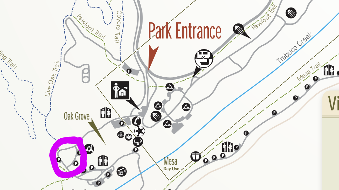
The hike we will be doing is approximately 5 miles with 870 ft. of elevation gain. We will begin at the Live Oak Trail trailhead. This is where you will see on the map that the Live Oak Trail hits the paved road. This is the parking lot closest to the Edna Spaulding Trail. (There […]

DSB (Journey Tribute) – Potluck Picnic, Concert, & Patriotic Drone Show!

Chumash Park 5550 Medea Valley Drive, Agoura Hills, CA, US

Join us as DSB celebrates and reinvents the timeless music of the legendary Journey Tribute followed by patriotic drone show! Let's enjoy potluck picnic before the concert. If your item requires utensils, please supply them. You may wish to bring your own cup, plate, and utensils in case there aren't any. Snacks and/or beverages to […]

Rosewood Trail to Angel Vista – Gentler Intermediate *** START at 8:00 ***

150 Regal Oak Ct 150 Regal Oak Ct, Thousand Oaks, CA, US

We will start our hike near the beginning of Regal Oak Ct. on the lower Rosewood Trail, a dirt trail heading up a shaded ravine at the base of the mountains, and continue to the usual Rosewood trail. Rosewood trail presents a clear view over the 101 Freeway carving up the Conejo Valley. This is […]

Intermediate 7 – 8 miles ~ Ray Miller Trail and Overlook Trail in Malibu

La Jolla Canyon 8588 Pacific Coast Hwy, 2 mi North of Sycamore Canyon, Ventura, CA, US

Join us on an out and back hike up the Ray Miller Trail and the Overlook Trail. We’ll enjoy beautiful ocean views as we descend. We'll pick up about 1300’ gain on this 7-8 mile adventure. Lying along the brilliant blue Pacific Ocean at the west end of Malibu (just shy of Port Hueneme), the […]

Mt. McCoy

Clinicas Del Camino Real Inc - Madera 1424 Madera Road, Simi Valley, US

Easy Intermediate, 3 miles, 600' gain Easier Option: 2.4 mi, 530' gain. (5 Washburn St, Simi Valley, CA 93065, or 89 La Paz Ct, Simi Valley, CA 93065 to save another 500' distance). We'll meet in the parking lot at the northeast corner of Madera and Royal, just south of the Donut Delite, on the […]


Trail statistics are approximate. For safety purposes always assume they are underestimated. But don’t be disappointed if they are overestimated. Bring more water and snacks than you think you’ll need.

Trail descriptions are based on previous hikes. Current conditions are unknown until arrival. Expect the unexpected and plan accordingly.

The Organizers and members of Hiking With Dean are not professional leaders, guides, or mountaineers. The function of the member or organizer is only to organize the trip. Each person who shows up for a trip/meetup (and their guest or guests) is responsible for his or her own safety. By attending a hike, or any other event organized by this group, you are acknowledging that you and any guests that you bring are aware of the risks, dangers and hazards associated with the activity and freely accept and fully assume all such risks, dangers and hazards, and further agree to release and discharge the Organizers, Members of the Hiking With Dean Meetup Group from and against any and all liability arising from your participation in the group activities per our ASSUMPTION OF RISK AND LIABILITY WAIVER and Section 6.2 of the Meetup.com Terms of Service.