BEFORE YOU WILL BE MOVED TO THE GOING LIST, YOU WILL NEED TO UPDATE YOUR CDH PROFILE (The three questions must be answered with a “yes”) IF YOU HAVE NOT ALREADY DONE SO.
NEED HELP:
[[go to: https://wp.me/P9MbG4-hC](go to: https:/](http://%5Bgo%20to:%20https//wp.me/P9MbG4-hC%5D(go%20to:%20https://wp.me/P9MbG4-hC))
Join me and experience the thrill of cross country hiking in the high country of the San Gabriel Mountains. We’ll visit two air force cargo plane crashes (C119 & C46) as we make our way from Mt. Williamson to Buckhorn Campground. At our half way point we’ll visit Goodykoontz Peak before dropping down to the cool pools of Little Rock Creek and Cooper Canyon Falls. This trek is only 8.5+ miles, but it packs a punch with a 3000′ overall gain consisting of some popular trails, “use” trails and no trail at all. This will be accomplished by way of a car shuttle and the drivers will need an ADVENTURE PASS.
This all day trek is for those of you who are looking for something a lot more challenging than the average outing. No beginners please unless you’re in top physical condition. Cross country hiking experience would help for this. If you have some place to be later in the day, this event will not work for you.
We will be setting a steady pace with several breaks while staying together all the way so as not to lose anyone.
**MICRO SPIKES, POLES AND GATORS ARE RECOMMENDED**
**AND DON’T FORGET THOSE WATER GUNS TO COOL OFF AT THE FALLS**
**DAY’S AGENDA**
**START:** After dropping a car off at Buckhorn Campground (Burkhart Trailhead), we’ll caravan to the The Williamson Trailhead where the trek begins to the 1ST PEAK.
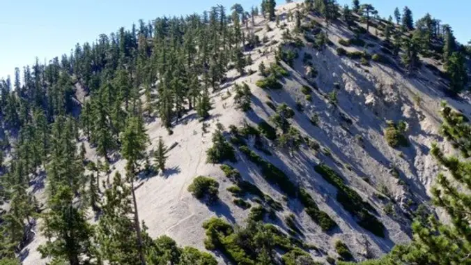
**1ST PEAK:** Mt. Williamson at 8214 ft. is the second highest peak north of highway 2 in the San Gabriel Mountains. From there we’ll follow THE RIDGE.
**THE RIDGE:** Pleasant View Ridge starting at Mt.Williamson offers continuous views over desert and high mountain country. IT’S HERE WHERE WE’LL TAKE A SIDE RIDGE ROUTE TO CHECK OUT THE CRASH SITE OF TWO AIR FORCE CARGO PLANES (A C46 AND A C119) before heading down to the 2ND PEAK.
**2ND PEAK**: Following yet another ridge takes us to Goodykoontz Peak at 7558′ which offers a great view of Williamson Rock below. From there we’ll drop down to the CREEK.
**THE CREEK:** Little Rock Creek is a desert bound creek fed by the springs high in the granite folds of Mt. Williamson. We will cross this beautiful creek at its 5640′ elevation point. In a short distance we’ll reach THE FALLS.
**THE FALLS:** “**Cooper Canyon Falls** is a beautiful waterfall that flows almost year round, but roars in April-May as the spring snow melts.” *Socalhiker*
**MEETUP LOCATION AND TIME:** 7:00 am at the meetup location on Hwy. 2 in La Canada. (BOOTS ON, READY TO GO).
***IF MEETING THE GROUP THERE, YOU MUST STATE SO, OTHERWISE I WON’T BE STOPPING THERE.***
MEETUP DIRECTIONS: From the 210 Fwy, exit at Angeles Crest Hwy and drive north about a quarter mile to just past Milmada Dr. in LA CANADA, then park alongside the road. We will all meet here no later than 7:30 a.m. and take as few cars as possible to Three Points Summit.
[https://www.google.com/maps/place/Three+Points+Trailhead/@34.3398586,-117.9997747,14z/data=!4m5!3m4!1s0x80c2e3a2211068bf:0xb78ddf64f081d3fc!8m2!3d34.343403!4d-117.9827788](https://www.google.com/maps/place/Three+Points+Trailhead/@34.3398586,-117.9997747,14z/data=!4m5!3m4!1s0x80c2e3a2211068bf:0xb78ddf64f081d3fc!8m2!3d34.343403!4d-117.9827788)
**EARLIER MEETUP LOCATION AND TIME:** 6:15am at the Woodland Hills Meetup location.
***IF MEETING THERE, LET ME KNOW, OTHERWISE I WON’T BE STOPPING THERE.***
[https://www.google.com/maps/place/34%C2%B010’04.0%22N+118%C2%B037’16.0%22W/@34.1677751,-118.6216512,228m/data=!3m2!1e3!4b1!4m6!3m5!1s0x0:0x0!7e2!8m2!3d34.1677741!4d-118.6211043](https://www.google.com/maps/place/34%C2%B010’04.0%22N+118%C2%B037’16.0%22W/@34.1677751,-118.6216512,228m/data=!3m2!1e3!4b1!4m6!3m5!1s0x0:0x0!7e2!8m2!3d34.1677741!4d-118.6211043)
**DURATION:** We’ll want to finish the hike and be back to the cars by 3:30 p.m. at the latest, followed by lunch at The Habit Burger Grill/ Pandera Bread in La Canada.
**TERRAIN:** A heavily used trail to Mount Williamson followed by well defined “use” trail along ridges which can be extremely steep at times. There is a very steep section with no trail at all.
**DISTANCE:** 9 miles
**ELEVATION RANGE**: Gain of 3000′ and a loss of 4300′
**THE PACE:** A comfortable pace no faster than the slowest hiker.
**LEVEL:** Advanced Intermediate
**MY CELL NUMBER IS:** 805-538-5972
**DOGS ALLOWED:** NO


