

This 11.7-mile lollipop route including a section of the Pacific Crest Trail offers a compelling journey through one of Southern California’s most distinctive geological landscapes. The moderately challenging route takes an average of 6 hours to complete, delivering hikers through lush desert canyons, dramatic rock formations, and seasonal creek crossings before culminating at the iconic Vasquez Rocks—those striking sandstone slabs tilted at impossible angles that you’ve undoubtedly seen in countless films and TV shows.
The trail’s highlight is its passage through Escondido Canyon, where the PCT descends into a beautiful riparian corridor with possible water crossings during wet seasons Around the 2.7-mile mark, you’ll encounter one of the hike’s most unusual features: a tall, unlit tunnel that carries the trail beneath Highway 14. Just north of this tunnel, hikers often find excellent spots for rest breaks, and midway through the hike on the southern side, there’s a small cave or overhang perfect for lunch. The route rewards you with panoramic views from ridgelines and the opportunity to spot wildlife ranging from crows to rattlesnakes, with spring bringing spectacular wildflower displays, particularly California poppies carpeting the south-facing slopes.
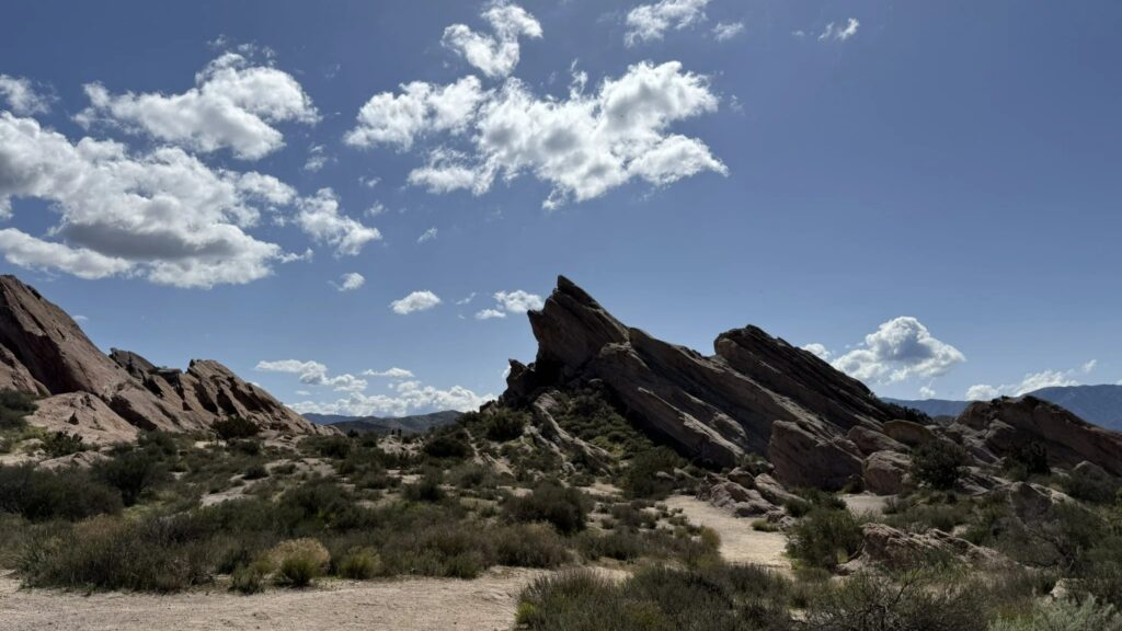
The Vasquez Rocks themselves were formed approximately 25 million years ago when the collision of the North American and Pacific tectonic plates uplifted sedimentary layers along the Elkhorn Fault. These coarse-grained sandstone formations accumulated from debris flows that eroded from the nearby San Gabriel and Sierra Pelona Mountains, creating alluvial fan deposits that were later buried, compressed, and dramatically tilted by ongoing seismic activity. The park holds deep cultural significance as well—it was added to the National Register of Historic Places in 1972 due to its importance as a prehistoric site for the Shoshone and Tataviam people. Whether you’re a geology enthusiast, history buff, or simply seeking a scenic desert hike with that quintessential SoCal filming location at the finish, this PCT section delivers a memorable outdoor experience accessible year-round.
DETAILS:
- Hike leader volunteer(s): Tim R.
- Meet: Vasquez Rocks rear parking area at 7:45 am, departure at 8:00 am sharp (Jan 31).
- Distance: Approximately 11.7 miles.
- Elevation gain: Approximately 2,402 feet.
- Time: Approximately 6.0 hours hiking including a snack break.
- Conditioning: You need to be in generally good physical condition.
- Dogs: Dogs are allowed.
- Restrooms: There are bathrooms at the trailhead.
- Adventure Pass: Not Required.
IMPORTANT NOTES: We’ll hike at a brisk pace and ask everyone to stay with the group for a friendly and safe outing. There are no expected stream crossings, exposures, bugs or other warnings. As always, people may slip and fall, encounter poison oak, snakes, etc. on this hike. This event may be cancelled due to inclement weather before or at the start of the hike. Check the weather report and plan accordingly.
ESSENTIAL GEAR: Hiking boots and poles. Clothing layers recommended. Snacks and 2+ liters of water and electrolytes or salt tablets. Hat and sunscreen.
The Ten Essentials of Hiking (link)
THIS HIKE RANKING: Level 4, Intermediate (see chart below).
Please only sign up to attend hikes that are consistent with your ability. Based on your hiking during the last 90 days, how would you score on the CHC Hike rating scale of one to five assuming a brisk pace?
CHC HIKE RANKING SCALE:
1. Beginner: 1-3 miles, less than 500 feet elevation gain.
2. Beginner/Intermediate: 1-7 miles, less than 700 feet elevation gain.
3. Intermediate: 5-10 miles, 1000-2000 feet elevation gain.
4. Intermediate/Advanced: 7-12 miles, up to 3000 feet elevation gain.
5. Advanced: 10-17 miles, 3000 feet or more elevation gain.
TRAILHEAD LOCATION: Vasquez Rocks rear parking area
NAVIGATION: We highly recommend the AllTrails app be installed on your cell phones and/or you print a copy of the trail map so you can personally navigate the trail if you need to.
The Community Hiking Club is a Non-Profit 501C3 organization. We rely on donations to continue sponsoring hikes like this. Please contribute by donating via: Cash contribution (at each hike), or via Zelle at 6617135610; or via Venmo at: @Heidi-Webber-5
DISCLAIMER / RELEASE OF LIABILITY – IMPORTANT, PLEASE READ BELOW IN ITS ENTIRETY:
When you sign up for this event, you are releasing Community Hiking Club from any liability or responsibility with your participation in this group activity. While safety is a priority for everyone in the group, hiking can be inherently risky. By participating in any posted event, you are assuming responsibility for your own safety and well-being. The Community Hiking Club (CHC) Meetup Group and its organizers and hike leaders are not trained leaders and we do not confirm the qualifications of any of its members to lead or participate in our events. All participants take full responsibility for their own actions. If you choose to sign up for any Community Hiking Club Meetup events, you are releasing the Community Hiking Club Meetup Group and Hike Leaders from all liability in case of possible injuries or death as stated in paragraph 6.2 of the Meetup “Terms of Service” located on the bottom of the Meetup website. Your personal safety depends on your own judgment and experience. If you sign up for this hike, you are verifying that this hike is within your abilities.


