

BEFORE YOU WILL BE MOVED TO THE GOING LIST, YOU WILL NEED TO UPDATE YOUR CDH PROFILE (The three questions must be answered with a “yes”) IF YOU HAVE NOT ALREADY DONE SO.
NEED HELP? Go to: [https://wp.me/P9MbG4-hC](https://wp.me/P9MbG4-hC)
**High winds, heavy rain, and hot weather will cancel this hike.**
This is a slow paced, stress free, social hike, at 5 miles with an elevation gain of about 554’. We hike together as a team and leave no one behind.
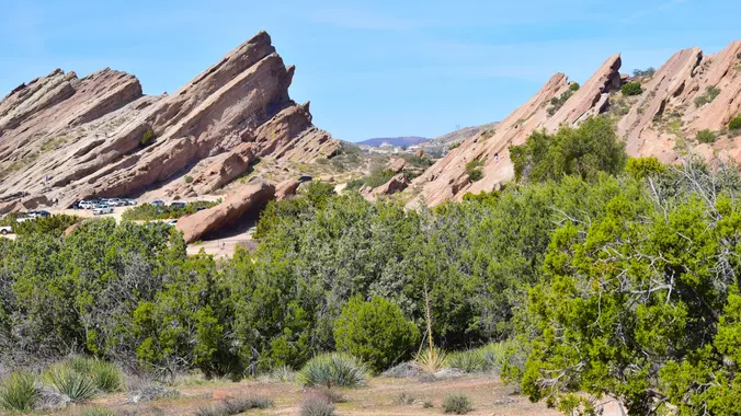
Were trekkin’ Vasquez Rocks and the PCT (Pacific Crest Trail), located in the high desert near Agua Dulce Springs, where numerous movies, commercials, music videos and TV shows were filmed, such as my favorite when Star Trek’s Captain Kirk battled the lizard “Gorn.” [https://www.youtube.com/watch?v=EVCarQr_Z2s](https://www.youtube.com/watch?v=EVCarQr_Z2s). The park features spectacular angled, jagged red rock formations. Vasquez got its name after one of California’s most notorious bandits, Tiburcio Vasquez, in 1874 he used these rocks to elude capture by law enforcement.
We will meet at the visitor’s center at 9:15am with a start time precisely at 9:30am.
If there are not parking spots available at the visitor’s center, keep driving down to the dirt parking lots, you’ll find more room there. Please arrive earlier, or after the hike if you’d like to walk through the visitor center (hours: 8-4) and learn more about the geology of this area.
There are restrooms and a water fountain at the Visitor’s Center.
From the visitor’s center we will make our way to the famous rock formations and take some time to explore and climb them. I will point out where Captain Kirk and the Gorn stood and take our group picture there.
We will head to the Pacific Crest Trail (PCT) and descend down into the canyons, to the wildlife tunnel that crosses below Highway 14. We will go through the tunnel and enjoy the scenery before turning around. Back at the canyons, we will take a break for snacks/lunch and do a little exploring. After our break, we will ascend above the rocks (most of the elevation gain is here), and make our way back to the visitor center.
Bring 2 liters of water, snacks/lunch, sunscreen, hats
Wear good hiking shoes/boots
* Distance: 5 miles, loop in the shape of a kite, see trail map in the photo gallery.
* Time: 9:15 – 12:30.
* Elevation Gain: about 554′
* Difficulty: Fit beginner/intermediate
* Dogs: Leashed, per State law
* Restrooms: At the Park Center
* Water Fountain: At the Park Center
* Parking: Free in the parking lot
* Known Dangers: Rattlesnakes, slip-‘n-fall.
**ADDRESS**
Vasquez Rocks Natural Area Park
10700 Escondido Canyon Rd, Agua Dulce, CA 91350
Google Coordinates: 34.489195, -118.320966
Google Map: https://www.google.com/maps/place/34%C2%B029’21.1%22N+118%C2%B019’15.5%22W/@34.4891994,-118.3231547,921m/data=!3m2!1e3!4b1!4m5!3m4!1s0x0:0x5cc23f9f2166eb15!8m2!3d34.489195!4d-118.320966?hl=en&authuser=0
**DRIVING DIRECTIONS**
* Head north on I-5 toward Santa Clarita valley.
* Take exit 162 for State Route 14 North (Antelope Freeway) going toward Lancaster/Palmdale.
* At about 14.3 miles take exit 15 for Agua Dulce Canyon Road
* continue about 5 minutes to the Vasquez Rocks Natural Area Park.


