

————————————————- THE QUEST —————————————–
WE’LL EXPLORE THE BIG HORN MINE AND CHECK OUT VINCENT’S CABIN
Join me and experience the thrill of exploring a mine high in the San Gabriel Mountains as we take on the Big Horn Mine.
This all day trek is for those of you who are looking for something different as we explore inside a mountain rather than on a mountain. If you have some place to be later in the day, this event will not work for you.
We will be setting a steady pace with several breaks while staying together all the way so as not to lose anyone.
POLES AND HARD HATS ARE RECOMMENDED
———————————————– DAY’S AGENDA —————————————
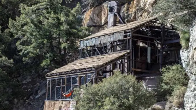
START: We’ll start the hike by taking an old dirt road leading from Vincent Gap to the BIG HORN MINE.
BIG HORN MINE: Named after the majestic Bighorn Sheep by Charles “Tom” Vincent while searching for the source of the gold found in the East fork of the San Gabriel River, it is by far the largest abandoned mine in the San Gabriel Mountain range, with a long and colorful history to match. Located deep beneath Mt. Baden Powell, it has been estimated that all tunnels combined measure well over two miles in length. We’ll check out several tunnels and map them as we go. After checking out the mine, on the way back to Vincent Gap, we can take a side route to Vincent’s Cabin.
VINCENT’S CABIN: A Civil War veteran, Charles “Tom” Vincent, settled and lived an isolated life near Vincent Gap. He prospected for gold and built a small cabin nearby of cedar and lupine, which also included ditches to channel water flow from a nearby spring.
—————————————- MEETUP LOCATIONS ————————————–
EARLIER MEETUP LOCATION AND TIME: Woodland Hills Meetup location at 6:15am.
IF MEETING THERE, LET ME KNOW, OTHERWISE I WON’T BE STOPPING THERE.
FINAL MEETUP LOCATION AND TIME: Vincent Gap along Hwy. 2 at 8:00am. We’ll all meet here.
———————————————– STATS ————————————————–
DURATION: We’ll want to finish the hike and be back to the cars by 3:00 p.m. at the latest, followed by lunch in Little Rock at the Charlie Brown’s Restaurant.
TERRAIN: Old dirt road between 6000′ and 7000′
DISTANCE: 5 miles
ELEVATION RANGE: Gain of 700′
THE PACE: A comfortable pace no faster than the slowest hiker.
LEVEL: Intermediate hiker
MY CELL NUMBER IS: 805-538-5972
DOGS ALLOWED: NO


