

****Waitlisted, limited to small group. Must follow CDC guidelines and you must have hiked with us previously
The plan is to take one of Don’s scramble routes to Simi Peak.
Not for beginners/no sweep
Should you join us, you must be okay with scrambling, possible bushwhacking, loose rocks, etc.
Write up is Don’s
The Stats
Distance: 7 miles
Rating: 5/10
Elevation gain: 1700 feet
The Trail: A loop trail w/ some minor exploration, single track and some uneven rock surfaces.
The Plan
NO shuttle as we’ve done in the past. From our meeting point on Lang Ranch Pkwy, we’ll head in on the Albertson Fireroad before heading straight up a “trail” I recently scouted to the Secret Pasage to Simi Peak (aka Rabbit Ridge). This will put us just below Simi Peak. Once at the peak, we’ll check out the awesome views of the surrounding areas before heading back to the cars. Our return, and much simpler route, will take us through China Flat and than back to Lang Ranch Pkwy via the Albertson Fireroad.
Note: This is the more rugged approach to Simi Peak and will have some rome rock scrambling and uneven trails.
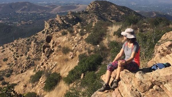
From Simi Peak (the highest point in the area), on a clear day, you can see the Simi Valley, Conejo Valley, San Fernando Valley, Oxnard Plains, Pacific Ocean and a few of the Channel Island
The Story
The Chumash Indians lived in these canyons for thousands of years. Many trails within the canyons were original Chumash trails before they were expanded by cattle ranchers. In this large expanse of habitat, deer, bobcats, coyotes and rabbits roam. Stroll to Sulphur Springs or hike to the top of Simi Peak and view the cities you’ve left behind.
Today, a great diversity of plants and animals live in the canyons. Wide-spread oaks and outcrops of sedimentary rock provide excellent nesting sites for owls, hawks and other raptors (birds of prey). The abundance of raptors indicates a large prey population, especially small mammals and reptiles. In more rugged areas where cattle didn’t graze, we can still find a variety of native plant communities, including chaparral, coastal sage scrub and riparian woodlands.
Directions
From the East, West & South – take the 101 toward Thousand Oaks. Exit at Westlake Boulevard and turn north (away from the ocean). Drive 4.1 miles and turn right on the Lang Ranch Parkway. Continue 0.8 miles and park where the Lang Ranch Parkway makes a sharp left.
From the North – take the 23 south toward Thousand Oaks. Exit at the Avenida De Los Arboles exit and turn left (east) on Avenida De Los Arboles. Drive 1.5 miles and turn right on Westlake Boulevard. Drive 0.2 miles and turn left on the Lang Ranch Parkway. Continue 0.8 miles and park where the Lang Ranch Parkway makes a sharp left.
Parking is free.
****************************************
The Fine Print
PLEASE – Know your limits and abilities. Bring snacks and drink plenty of liquids when hiking. Check weather conditions and dress accordingly and be aware of your surroundings at all times. Watching out for poison oak, snakes, ticks, uneven footing, spectacular views, beautiful fauna all while interacting with awesome (usually) fellow hikers can be extremely hazardous, rewarding and fun.
The Farzan Rule: Posted hike times are the time the hike starts or we leave from a posted shuttle location. I’m aware other Meetup groups offer a grace period for late arrivals; we don’t. It’s your responsibility to know the location of the meeting spot and be there and ready to participate at the posted time. If you have any concerns about the directions feel free to contact the organizer of the event, preferably in advance of the event and not at the start time. I’m of the opinion that it’s not fair to delay an event when the majority of attendees have arrived on-time. (so named after a conversation I had with a certain un-named member)
RSVP’s: If you RSVP for an event be responsible and update your RSVP if your plans change. If your plans change at the last second and you’re not able to update your RSVP also let us know. In my opinion a no-show is someone who has no regard for following the guidelines we request from our members and will risk being removed from future events that have a limit.
VHC HIKE RATING SCALE
Rating a hike is subjective, meaning the difficulty of a hike will be in direct relation to how often you hike and the type of hike you prefer. Keep in mind that any hike can have the following: un-even hiking surfaces, various obstructions, water and/or water crossings or bouldering and/or rock hopping. A great hike will have all of these!
1 – A long walk
2 – 4 mile hike w/little elevation gain
3 – 5 mile hike w/up to 1000 ft. elevation gain
4 – 5+ mile hike w/up to 1500 ft. elevation gain (heart rate increases at times)
5 – 7+ mile hike w/over 1500 ft. elevation gain (heart rate increasing even more at times)
6 – 7+ mile hike w/over 2000 ft. elevation gain (at times you might be trying to remember how to perform CPR)
7 – 5+ mile hike w/over 2000 ft. elevation gain (at times you might be muttering expletives to yourself)
8 – 10+ mile hike w/over 3500 ft. elevation gain (at times you might be angry with the hike leader)
9 – 10+ mile hike w/over 5000 ft. elevation gain (at times you might be thinking of reporting the hike leader to the authorities)
10 – Use your imagination
Class 3 Scrambling: Scrambling or un-roped climbing. You must use your hands at times to hold the terrain or find your route. This may be caused by a combination of boulders, steepness and extreme terrain. Some Class 3 routes have ropes in place for assistance.
DISCLAIMER / RELEASE OF LIABILITY
IMPORTANT, PLEASE READ BELOW IN ITS ENTIRETY:
I am a volunteer (i.e. not liable for the group). Safety is a priority for everyone in the group. Think of this as hiking with a group of friends.
Outdoor sports and other events we plan can be inherently dangerous and accidents may happen. By participating in any posted event, you’re taking responsibility for your own safety and well-being. The VHC Meetup Group and its organizers are not trained leaders and we do not confirm the qualifications of any of its members to lead or participate in trips. All participants take full responsibility for their own actions. If you choose to sign up for any VHC Meetup events, you are releasing the VHC Meetup Group and it’s organizers from all liability in case of possible injuries as stated in paragraph 6.2 of the Meetup “Terms of Service” located on the bottom of the Meetup website. Your personal safety depends on your own judgment and experience.
*****************************************
*****************************************


