

BEFORE YOU WILL BE MOVED TO THE GOING LIST, YOU WILL NEED TO UPDATE YOUR CDH PROFILE (The three questions must be answered with a “yes”) IF YOU HAVE NOT ALREADY DONE SO.
NEED HELP:
go to: [https://wp.me/P9MbG4-hC](https://wp.me/P9MbG4-hC)
SANTA BARBARA COAST- SERIES OF HIKES
Join me on yet another CDH series as I take on the Santa Barbara Coastal Range. We’ll hike a series of trails we’ve taken before that will be interesting with views of the ocean on most of them. Starting north at Gaviota, we’ll conclude the series in Montecito. This series is definitely meant to be more visual than physical, thus, less conditioning but more of a mental enlightenment. Therefore, we will hike together as a group and enjoy the beauty that this series offers.
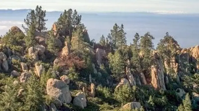
ROCK GARDEN AND WHITE MOUNTAIN
This next trek in the Santa Barbara series will take us to The Rock Garden and White Mountain. After checking those two areas, we’ll drop down the Tunnel trail to the Rattlesnake connector trail that will take us to our cars initially dropped off on Gibraltar Rd. We’ll do this one via a 15 minute car shuttle. This will be a 70% downhill hike consisting of 4+ miles overall. As we’re halfway down the Tunnel Trail we’ll be able to view Mission Falls. There will be some rock scrambling in THE ROCK GARDEN an extremely rocky area, but the rest of the hike will be on a well traveled trail. After the hike, you can join me for an optional late lunch debriefing.
INITIAL MEETUP LOCATION, DIRECTIONS AND TIME: The Thousand Oaks Park and Ride at the corner of Rancho Rd. and Haaland Dr. NO LATER THAN 6:30 a.m. It’s just south of the 101 Fwy and 23 Fwy interchange. Have a full tank of gas and be willing to drive if needed. Those that don’t drive can help pay for gas. It’s about 1.2 hour’s drive to the trailhead.
[https://www.google.com/maps/place/34%C2%B010’26.8%22N+118%C2%B051’39.0%22W/@34.1741264,-118.8630207,17z/data=!3m1!4b1!4m14!1m7!3m6!1s0x80dcd0bd18abdaed:0x31495eac78f71848!2sVilla+Park,+CA!3b1!8m2!3d33.8140062!4d-117.8220723!3m5!1s0x0:0x5d245dcb416937cd!7e2!8m2!3d34.1741224!4d-118.8608322](https://www.google.com/maps/place/34%C2%B010’26.8%22N+118%C2%B051’39.0%22W/@34.1741264,-118.8630207,17z/data=!3m1!4b1!4m14!1m7!3m6!1s0x80dcd0bd18abdaed:0x31495eac78f71848!2sVilla+Park,+CA!3b1!8m2!3d33.8140062!4d-117.8220723!3m5!1s0x0:0x5d245dcb416937cd!7e2!8m2!3d34.1741224!4d-118.8608322)
FINAL MEETUP LOCATION AND TIME: The Upper Rattlesnake Trail trailhead on Gibraltar Road no later than 8:00 a.m. (SEE MAP ABOVE)
FINAL MEETUP DIRECTIONS: Use the following directions as a guide when heading up to the upper Rattlesnake trailhead on Gibraltar Road. From there we’ll take a 15 minute car shuttle to the Rock Garden trailhead.
[https://www.google.com/maps/dir/34.4743033,-119.6812563/Thousand+Oaks,+California/@34.4559047,-119.6622699,13.23z/data=!4m14!4m13!1m5!3m4!1m2!1d-119.6807932!2d34.4734684!3s0x80e96cb3a7da1c71:0x5fdb2f7dc94027e!1m5!1m1!1s0x80e8255670288891:0x8d2e7a0147cc2e26!2m2!1d-118.8375937!2d34.1705609!3e0](https://www.google.com/maps/dir/34.4743033,-119.6812563/Thousand+Oaks,+California/@34.4559047,-119.6622699,13.23z/data=!4m14!4m13!1m5!3m4!1m2!1d-119.6807932!2d34.4734684!3s0x80e96cb3a7da1c71:0x5fdb2f7dc94027e!1m5!1m1!1s0x80e8255670288891:0x8d2e7a0147cc2e26!2m2!1d-118.8375937!2d34.1705609!3e0)
DISTANCE: 4+ miles
ELEVATION GAIN/LOSS: 1000’/1900′
THE PACE: As fast as the slowest Trekker
DURATION: 6+ hours
TERRAIN: Single, double track and “use” trails along with some rock scrambling
LEVEL: Intermediate Trekker
OPTIONAL LUNCH: After the hike, I will be debriefing at the Shalhoob’s Funk Zone Patio for lunch
220 Gray Avenue, Santa Barbara
MENU: [https://shalhoob.com/menu](https://shalhoob.com/menu)
MY CELL# IS: 805-358-5972


