

DESCRIPTION: This 5-mile out-and-back hike isn’t a walk in the park. It is located in the Angeles National Forest. It’s a steep climb that zigzags between paved roads and dirt trails, keeping your legs (and your sense of adventure) on their toes. Along the way, you’ll enjoy beautiful views, interesting rock formations, and a mix of sun and shade that can change the temperature and wind exposure in minutes.
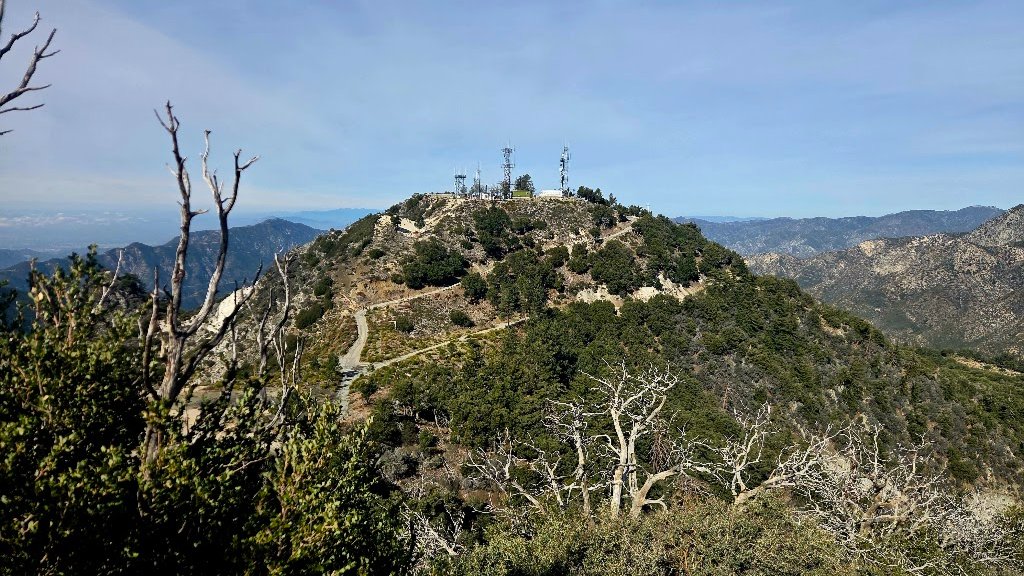
We’ll start at Mount Disappointment, take in the views, and then continue to San Gabriel Peak for a snack break while soaking up even more incredible scenery.
Steep, scenic, and full of surprises — this hike is proof that even “disappointment” can lead to spectacular views!
DETAILS:
· Hike Organizer(s): Michele E.
· Meet: Trailhead near small parking lot at 7:15 am,
departure at 7:30 am sharp (Mar 21).
· Distance: Approximately 5.0 miles.
· Elevation gain: Approximately 1604 feet.
· Time: Approximately 3.5 hours hiking including a snack break.
· Conditioning: You need to be in generally good physical condition.
· Dogs: Dogs are allowed.
· Restrooms: None closest one is at Redbox)
· Adventure Pass: Required.
IMPORTANT NOTES: We’ll hike at a slower pace and ask everyone to stay with the group for a friendly and safe outing. Hiking may be hazardous due to uneven footing, stream crossings, exposures, snakes, bugs, poison oak, etc. Please be aware of your abilities and their limits. You are responsible for your own safety and well-being. This event may be cancelled due to inclement weather or other conditions. You can check the weather and other conditions on the AllTrails GPS Trail Map link below.
ESSENTIAL GEAR: Hiking boots and poles. Clothing layers recommended. Snacks and 2+ liters of water and electrolytes or salt tablets. Hat and sunscreen.
The Ten Essentials of Hiking (link)
THIS HIKE RANKING: Level 3, Intermediate (see chart below).
Please only sign up to attend hikes that are consistent with your ability. Based on your hiking during the last 90 days, how would you score on the CHC Hike rating scale of one to five assuming a brisk pace?
CHC HIKE RANKING SCALE:
1. Beginner: 1-3 miles, less than 500 feet elevation gain.
2. Beginner/Intermediate: 1-7 miles, less than 700 feet elevation gain.
3. Intermediate: 5-10 miles, 1000-2000 feet elevation gain.
4. Intermediate/Advanced: 7-12 miles, up to 3000 feet elevation gain.
5. Advanced: 10-17 miles, 3000 feet or more elevation gain.
TRAILHEAD LOCATION: From Angeles Crest Highway, turn right at the Redbox parking lot. Do not park here. This is a convenient spot to use the restroom before heading up if needed.
The trailhead itself is easy to miss. Follow Google Maps carefully. It’s a small, unmarked turn to the right, and it might feel like you’ve already passed it. There are 4–5 parking spots just above near the gate, or you can park along the road below.
NAVIGATION: We highly recommend the AllTrails app be installed on your cell phones and/or you print a copy of the trail map so you can personally navigate the trail if you need to.
The Community Hiking Club is a Non-Profit 501C3 organization. We rely on donations to continue sponsoring hikes like this. Please contribute by donating via: Cash contribution (at each hike), or via Zelle at 6617135610; or via Venmo at: @Heidi-Webber-5
DISCLAIMER / RELEASE OF LIABILITY – IMPORTANT, PLEASE READ BELOW IN ITS ENTIRETY:
When you sign up for this event, you are releasing Community Hiking Club from any liability or responsibility with your participation in this group activity. While safety is a priority for everyone in the group, hiking can be inherently risky. By participating in any posted event, you are assuming responsibility for your own safety and well-being. The Community Hiking Club (CHC) Meetup Group and its organizers and hike leaders are not trained leaders and we do not confirm the qualifications of any of its members to lead or participate in our events. All participants take full responsibility for their own actions. If you choose to sign up for any Community Hiking Club Meetup events, you are releasing the Community Hiking Club Meetup Group and Hike Leaders from all liability in case of possible injuries or death as stated in paragraph 6.2 of the Meetup “Terms of Service” located on the bottom of the Meetup website. Your personal safety depends on your own judgment and experience. If you sign up for this hike, you are verifying that this hike is within your abilities.


