

BEFORE YOU WILL BE MOVED TO THE GOING LIST, YOU WILL NEED TO UPDATE YOUR CDH PROFILE (The three questions must be answered with a “yes”) IF YOU HAVE NOT ALREADY DONE SO.
NEED HELP:
go to: https://wp.me/P9MbG4-hC
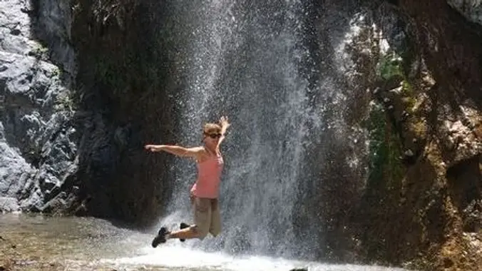
Once again I’ll be leading a WWW trek into the Cucamonga Wilderness area to see the three tier waterfall in the west fork of Lytle Creek. Signing on to this event is saying that you welcome the idea of being soaked by the WWW and will be participating in the folly. It’s a great way to stay cool in a hot environment.
This is one of our favorite Wednesday hikes that I have posted. This event will have us once again hike the Middle Fork of Lytle Creek to a 200′ three tier waterfall.
WARNING: THERE WILL BE WWW MEMBERS ON THIS TRIP – SO PLAN ON GETTING WET. SOMEHOW, I SEEM TO ALWAYS BE THEIR TARGET WHEN I LEAST EXPECT IT AS SEEN IN THE FOLLOWING VIDEO:
[https://www.youtube.com/watch?v=UdAXPgPC3jo&feature=youtu.be](https://www.youtube.com/watch?v=UdAXPgPC3jo&feature=youtu.be)
WHICH LEADS TO ALL OUT WATER FIGHTS AS THIS VIDEO SHOWS:
[https://www.youtube.com/watch?v=VtjLTfH-RRY&feature=youtu.be](https://www.youtube.com/watch?v=VtjLTfH-RRY&feature=youtu.be)
THE HIKER’S WAY [http://www.thehikersway.com/hiking-by-area/san-gabriel-mountains/middle-fork-lytle-creek-to-lower-fall-set/](http://www.thehikersway.com/hiking-by-area/san-gabriel-mountains/middle-fork-lytle-creek-to-lower-fall-set/)
write up for this event. Besides soaking in the pool below the lower falls, you’ll have the option to scramble to the top of the upper falls. Check out that site above and you’ll have a hard time saying no to joining us in this fantastic area.
It’s important to bring an SUV if you have one and to show up at the Glendale park and ride. We’ll fill those SUVs at that point and head over to the Lytle Creek Trailhead. It’s a two mile rough dirt forest service road that SUVs can handle, but sedans can’t.
AFTER SIGNING UP, PLEASE POST IF YOU’RE BRINGING AN SUV OR FOUR WHEEL DRIVE. THIS EVENT MAY REQUIRE US TO DRIVE AT LEAST 2 MILES OF DIRT ROAD TO GET TO THE TRAILHEAD.
If you have to be somewhere later that day, don’t commit to this. The hike will be over when it’s over.
MEETUP TIME, LOCATION AND DIRECTIONS: Take the 134 Fwy east and exit Harvey Dr. heading south. Make a right on E. Wilson Ave. followed immediately by a right into the Park And Ride there. Whether you meet at an earlier location or not, you’ll all be required to meet at our caravan location at the park and ride in Glendale. We’ll all meet there at 7:30 a.m. and fill up the SUVs. Those taking sedans to the trailhead, will have at least an extra 2.2 miles more each way than what’s posted. Have a full tank in your SUV. Those that don’t drive can help pay for gas.
[MEETUP LOCATION](https://www.google.com/maps/place/34%C2%B008’50.8%22N+118%C2%B013’49.2%22W/@34.147455,-118.2309079,217m/data=!3m2!1e3!4b1!4m15!1m8!3m7!1s0x0:0x761a5b4a65afcdf2!2zMzTCsDE0JzM4LjYiTiAxMTfCsDMwJzIxLjkiVw!3b1!7e2!8m2!3d34.2440667!4d-117.5060734!3m5!1s0x0:0x92545dc015503e78!7e2!8m2!3d34.1474548!4d-118.2303351)
EARLIER MEETUP LOCATION: Those out my way can meet me in Woodland Hills at 7:00 a.m. and take off from there in a car pool. Meet at the corner of Leonora Dr. and Ponce Avenue. Ponce Ave. is the first street east of Fallbrook. We can park on Ponce which is not in front of any homes. We can load the cars up here, since there isn’t a car shuttle involved on this event.
[EARLIER MEETUP LOCATION](https://www.google.com/maps/place/34%C2%B010’04.4%22N+118%C2%B037’16.0%22W/@34.167893,-118.6230642,17z/data=!3m1!4b1!4m6!3m5!1s0x0:0xf01a5eb66e31ecce!7e2!8m2!3d34.1678925!4d-118.6210981)
FINAL MEETUP LOCATION: We’ll finally all meet at 14084 Middle Fork Rd, Lytle Creek, at 8:30 a.m. From there we’ll drive up to two miles on a forest service dirt road to the trailhead.
[FINAL MEETUP DESTINATION](https://www.google.com/maps/place/34%C2%B014’38.6%22N+117%C2%B030’21.9%22W/@34.244067,-117.5082305,817m/data=!3m2!1e3!4b1!4m6!3m5!1s0x0:0x761a5b4a65afcdf2!7e2!8m2!3d34.2440667!4d-117.5060734)
TRAILHEAD ACCESS VIA DIRT FOREST SERVICE ROAD: 2.2 MILES – SUVs needed for this.
ELEVATION GAIN/LOSS:2000’/2000’
DISTANCE: 8.5 miles
TERRAIN: Single track trail and creek and rock scrambling
EXPERIENCE LEVEL: Strong intermediate hiker capable of hiking rough
areas off trail
DEBRIEFING: After the hike, as an option, we can stop off at a restaurant on the way home for a late lunch
ADVENTURE PASS: Will be required at the Lytle Creek trailhead.
MY CELL# IS: 805-358-5972


