

It looks like we can once again make a nice 10 mile loop up Las Llajas Canyon. We’ll pass by some of the first oil wells drilled in California in the early 1900’s and take a break at the 1920’s excavator left behind from the Coquina Mine.
STATS
Distance: 10+ mi
Elevation Gain: 2,200 ft
Rating: 7/10
Trail: Fire-road, trail, loop
Pace: Moderate
Fees/pass: none
THE STORY
In the early 1900s this land was owned by the Simi Valley Oil Company and later purchased by Howard Marr in the 1920s. It became known as Marrland. In 1929 Howard Marr leased a portion of his land to the Tapo Alto Shell and Fertilizer Company to mine for limestone.
Heavy equipment was brought in to strip the hilltop of an unusually pure form of calcium carbonate from a fossilized reef called Coquina Limestone (shell or oyster limestone). The State Department of Agriculture found it to be 98% pure. At one time, this entire area was underwater and you can see evidence of this in the thousands of shells embedded in the rock near the mine.
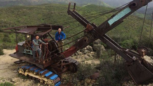
Mining operations ceased in 1935. The road used to bring in equipment had been largely washed away and much of the mining equipment was left behind. The main attraction is the P&H Company power shovel. It’s a Model 206, considered to be a small power shovel but it put P&H on the map. The company would ultimately meet its downfall due to asbestos in the brake linings. Asbestos was touted as a miracle mineral for much of the 20th century. At P&H’s manufacturing plants, brake linings regularly had to be grinded down in order to fit casings on cranes and other machinery. The process released large amounts of asbestos dust into the air, polluting the work environment and putting workers’ health at risk.
Some interesting history about the name: Las Llajas was first used in 1931 and is likely a misspelling of the spanish words las llagas which translates to the wounds, referring to the stigmata of a Roman Catholic saint. From 1914-1920 a cult called Pisgah Grande lived in this canyon and created a secluded colony with 30 buildings. It had over 300 members. If you look in the right places, you can still find old bricks stamped with Pisgah markings where buildings used to rest.
**************************
The Fine Print
PLEASE – Know your limits and abilities. Bring snacks and drink plenty of liquids when hiking. Check weather conditions and dress accordingly and be aware of your surroundings at all times. Watching out for poison oak, snakes, ticks, uneven footing, spectacular views, beautiful fauna all while interacting with awesome (usually) fellow hikers can be extremely hazardous, rewarding and fun.
The Farzan Rule: Posted hike times are the time the hike starts or we leave from a posted shuttle location. I’m aware other Meetup groups offer a grace period for late arrivals; we don’t. It’s your responsibility to know the location of the meeting spot and be there and ready to participate at the posted time. If you have any concerns about the directions feel free to contact the organizer of the event, preferably in advance of the event and not at the start time. I’m of the opinion that it’s not fair to delay an event when the majority of attendees have arrived on-time. (so named after a conversation I had with a certain un-named member)
RSVP’s: If you RSVP for an event be responsible and update your RSVP if your plans change. If your plans change at the last second and you’re not able to update your RSVP also let us know. In my opinion a no-show is someone who has no regard for following the guidelines we request from our members and will risk being removed from future events that have a limit.
VHC HIKE RATING SCALE
Rating a hike is subjective, meaning the difficulty of a hike will be in direct relation to how often you hike and the type of hike you prefer. Keep in mind that any hike can have the following: un-even hiking surfaces, various obstructions, water and/or water crossings or bouldering and/or rock hopping. A great hike will have all of these!
1 – A long walk
2 – 4 mile hike w/little elevation gain
3 – 5 mile hike w/up to1000 ft. elevation gain
4 – 5+ mile hike w/up to1500 ft. elevation gain (heart rate increases at times)
5 – 7+ mile hike w/over 1500 ft. elevation gain (heart rate increasing even more at times)
6 – 7+ mile hike w/over 2000 ft. elevation gain (at times you might be trying to remember how to perform CPR)
7 – 5+ mile hike w/over 2000 ft. elevation gain (at times you might be muttering expletives to yourself)
8 – 10+ mile hike w/over 3500 ft. elevation gain (at times you might be angry with the hike leader)
9 – 10+ mile hike w/over 5000 ft. elevation gain (at times you might be thinking of reporting the hike leader to the authorities)
10 – Use your imagination
Class 3 Scrambling: Scrambling or un-roped climbing. You must use your hands at times to hold the terrain or find your route. This may be caused by a combination of boulders, steepness and extreme terrain. Some Class 3 routes have ropes in place for assistance.
DISCLAIMER / RELEASE OF LIABILITY
IMPORTANT, PLEASE READ BELOW IN ITS ENTIRETY:
I am a volunteer (i.e. not liable for the group). Safety is a priority for everyone in the group. Think of this as hiking with a group of friends.
Outdoor sports and other events we plan can be inherently dangerous and accidents may happen. By participating in any posted event, you’re taking responsibility for your own safety and well-being. The Valencia Hiking Crew Meetup Group and its organizers are not trained leaders and we do not confirm the qualifications of any of its members to lead or participate in trips. All participants take full responsibility for their own actions. If you choose to sign up for any Valencia Hiking Crew Meetup events, you are releasing the Valencia Hiking Crew Meetup Group and it’s organizers from all liability in case of possible injuries as stated in paragraph 6.2 of the Meetup “Terms of Service” located on the bottom of the Meetup website. Your personal safety depends on your own judgment and experience.


