

Details
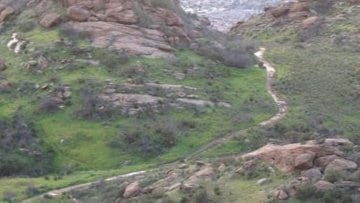
Join us for a the grand loop around 5,000-acre Rocky Peak Park. RPP in the Santa Susana Mountains straddles the Los Angeles-Ventura county line at the eastern end of Simi Valley. A network of hiking trails weaves through the park that is home to deep oak-lined canyons, trickling streams, and massive, sculpted sandstone formations with a moonscape appearance.
On November 11, 2012 we did this one in the rain. See photos: https://www.meetup.com/localhikers/events/90262762/
The Hummingbird Trail, at the base of Rocky Peak, crosses Hummingbird Creek and climbs up a narrow canyon through open chaparral to the Rocky Peak Fire Road, passing stacks of giant sandstone boulders, sculpted caves, and dramatic rock outcroppings.
The original Hummingbird Trail (and a popular alternate that goes by the Swing Cave) has been destroyed by the mountain bikers long ago. I have a new trail in the area that still remains virtually untouched by the knobs. I call it El Nido de Chuparosas trail
[asa2_collection tpl=”Flat_box_horizontal” orderby=”rand” show_features=”no” show_description=”no” limit=”1″]2[/asa2_collection]
The Chumash Trail ascends the west flank of Rocky Peak. The trail winds up the chaparral cloaked mountainside to the ridge north of Rocky Peak, passing sculpted sandstone outcroppings, caves, fossils, fault lines and a series of scenic overlooks and highland meadows. From Hamilton Saddle and the Rocky Peak Trail junction are panoramic views of the Simi Hills, Simi Valley, San Fernando Valley, the Santa Susana Mountains, the Santa Monica Mountains, Blind Canyon, and Las Llajas Canyon.
Rocky Peak gets its name from the many large craggy boulders that dot its surface. At 2,715 feet Rocky Peak is the third-highest point in the Santa Susana Mountains, and overlooks the San Fernando Valley and Chatsworth, the Simi Hills, and the Simi Valley in Southern California.
The peak sits on the Los Angeles County–Ventura County line and marks the point where the county line changes direction from true North to a more North-Westerly direction. A large railroad spike driven into the rocks mark this exact spot on the county line.
Hike is appx 8 miles with about 2,100 feet net elevation gain and is rated DIFFICULT. See https://www.hikingwithdean.com/hike-rating-guide/
Bring plenty of water and snacks
Directions to trailhead:
Take the 118 Freeway and exit at KUEHNER. Turn North at the end of the off ramp and park at the end of Kuehner


