

Join us for the first hike of 2020 at the Circle X Ranch. The Mishe Mokwa Trail is known as the most beautiful trail in the Santa Monica Mountains. Round trip distance is 7.5 miles with a net elevation gain of 1000 feet (about 1700 total).
During Wednesday’s hike we will be visiting 2 Earthcaches: Sandstone Peak and Inspiration Point
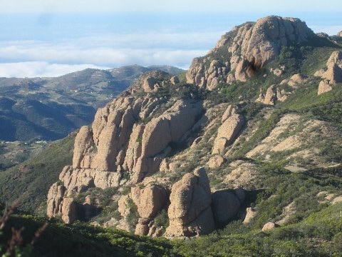
Sandstone Peak, the highest peak in the Santa Monica Mountains at 3,111 feet, is not sandstone at all. Its actually made of igneous rock formed 15 million years ago during the Conejo Volcanics. During this time Sandstone Peak grew to 10,000 feet! After millions of years of erosion we are now left with its ruddy-colored core. From a distance its color makes it look like sandstone, hence the name Sandstone Peak.
At Inspiration Point we will see more evidence of how the Santa Monica Mountains were formed. From here, a view of Los Angeles, Oxnard Plain, and the Valleys of Southern California will reveal the evolution of the Farallon Plate subduction zone that created the transverse mountain range known as the Santa Monica Mountains. The Channel Islands, which were created at the same time and by the same process that created the Santa Monica Mountains, can be seen from here too.
We’ll take a side trip to Tri-Peaks, a stack of house-sized volcanic boulders. We’ll take our main break here and explore the fascinating slots and caves beneath the giant boulders.
Event rules:
1. Carpooling is required. No more than than 10 cars shall be part of the group. There is a convenient park-and-ride at Kanan & Canwood and Kanan & Roadside. The corner of Ventura and Topanga in Ralph’s parking lot is a good meeting spot also
2. All hikers must stay on established trails
3. No use of flour or chalk to mark trails.
4. Practice “Leave No Trace” – take only pictures and leave only footprints
Directions to Trailhead:
Use this link for Google Map (http://maps.google.com/maps?f=d&source=embed&saddr=34.114167,-118.91814&daddr=&hl=en&geocode=&mra=dme&mrcr=0&mrsp=0&sz=17&sll=34.114292,-118.919857&sspn=0.003642,0.006866&ie=UTF8&ll=34.112053,-118.927388&spn=0.012436,0.023603&z=15)
Park at the Mishe Mokwa trailhead.
Mishe Mokwa Trailhead parking lot is on the both sides of Yerba Buena Rd, 3.75 miles west of Mulholland or 7.2 miles north of PCH. Yerba Buena is very curvy so drive carefully.
San Fernando Valley/Calabasas:
From points east of Westlake Village, exit 101 at Kanan and go south to Mulholland. Turn west (right) to Yerba Buena 2 mi.
From the 101:
Exit and turn south at CA-23 (Westlake Blvd)
Continue to follow CA-23 south 5.2 mi. Continue straight toward Mulholland Hwy West
After a couple more miles, turn right at stop sign and continue west on Mulholland Hwy 0.4 mi
Turn right at Little Sycamore Canyon Rd 1.9 mi
Slight left at Yerba Buena Rd 2 mi
[Overflow parking: Sandstone Peak 0.75 farther down, Circle X Ranch 1.75 miles down toward PCH]


")


